Tetla elevation
Tetla (Veracruz, Chocamán), Mexico elevation is 1513 meters and Tetla elevation in feet is 4964 ft above sea level [src 1]. Tetla is a populated place (feature code) with elevation that is 199 meters (653 ft) bigger than average city elevation in Mexico.
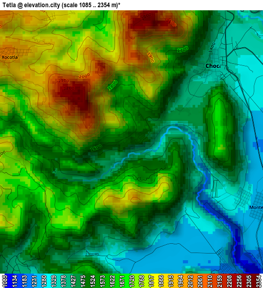
Below is the Elevation map of Tetla, which displays elevation range with different colors. Scale of the first map is from 1085 to 2354 m (3560 to 7723 ft) with average elevation of 1587.5 meters (=5208 ft) [note 1]
These maps also provides idea of topography and contour of this city, they are displayed at different zoom levels. More info about maps, scale and edge coordinates you can find below images.
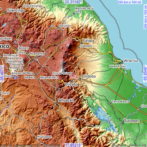
| \ | Map #1 | Topo.Map |
| Scale [m] | 1085..2354 m | × |
| Scale [ft] | 3560..7723 ft | × |
| Average | 1587.5 m = 5208 ft | × |
| Width | 9.24 km = 5.7 mi | 295.7 km = 183.7 mi |
| Height | 9.24 km = 5.7 mi | 295.7 km = 183.7 mi |
| ↑Max Latitude | 19.028639° | 20.31142° |
| Latitude at center | 18.98709° | 18.98709° |
| ↓Min Latitude | 18.94553° | 17.65215° |
| ← Min Longitude | -97.104795° | -98.4671° |
| Longitude center | -97.06085° | -97.06085° |
| →Max Longitude | -97.016905° | -95.6546° |
Nearby cities:
Cities around Tetla sort by population:
• Chocamán elevation 1358 m
4 km,  46°
46°
• Xocotla 2013 m
5.2 km,  306°
306°
• Monte Blanco 1254 m
5.2 km,  116°
116°
• Dos Ríos 1220 m
5.7 km,  143°
143°
• Tomatlán 1364 m
7.3 km, 47°
• Tocuila 1221 m
6.2 km,  131°
131°
• Monte Salas 1180 m
7.1 km, 141°
• La Sidra 1342 m
6.3 km,  198°
198°
• San José Neria 1210 m
6.5 km,  83°
83°
• Santa Lucía Potrerillo 1292 m
4.3 km, 117°
• Tetlaxco 1656 m
5.9 km,  356°
356°
• Xalatlaco 1526 m
7.3 km,  16°
16°
Multilingual:
 En español:
Tetla elevación 1513 m.
 En France:
Tetla élévation 1513 m.


Sources and notes:
- [note 1] Map square and city borders are not equal. Map elevation data is calculated only from area inside that square.
- [src 1] Elevation data from geonames database provided with same terms of usage.
- [src 2] The elevation map of Tetla is generated using elevation data from NASA's 3 arcsec (90m) resolution SRTM data.
- [src 3] Base (background) map © OpenStreetMap contributors tiles are generated by Geofabrik and OpenTopoMap.
Copyright & License:
This Tetla Elevation Map is licensed under CC BY-SA. You may reuse any part from this page, if you give a proper credit by linking to this URL:
 More info on terms of use page.