Xocotla elevation
Xocotla (Veracruz, Coscomatepec), Mexico elevation is 2013 meters and Xocotla elevation in feet is 6604 ft above sea level [src 1]. Xocotla is a populated place (feature code) with elevation that is 699 meters (2293 ft) bigger than average city elevation in Mexico.
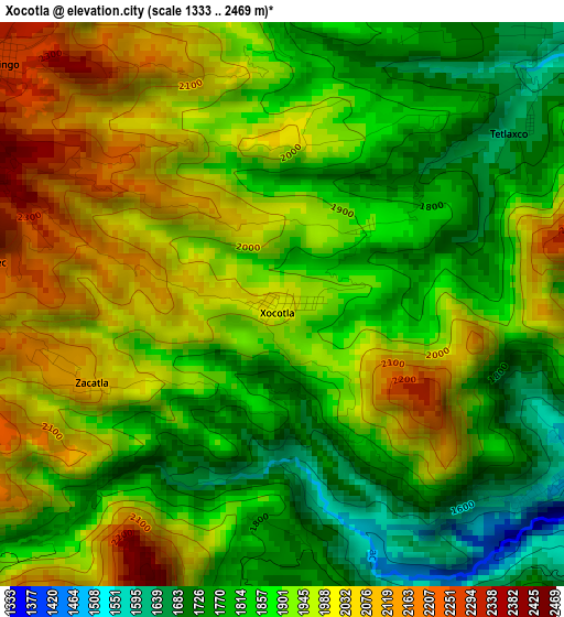
Below is the Elevation map of Xocotla, which displays elevation range with different colors. Scale of the first map is from 1333 to 2469 m (4373 to 8100 ft) with average elevation of 1911.5 meters (=6271 ft) [note 1]
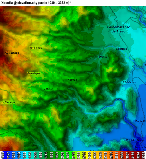
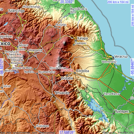
These maps also provides idea of topography and contour of this city, they are displayed at different zoom levels. More info about maps, scale and edge coordinates you can find below images.
| \ | Map #1 | Map #2 | Topo.Map |
| Scale [m] | 1333..2469 m | 1039..3332 m | × |
| Scale [ft] | 4373..8100 ft | 3409..10932 ft | × |
| Average | 1911.5 m = 6271 ft | 1924.5 m = 6314 ft | × |
| Width | 9.24 km = 5.7 mi | 18.48 km = 11.5 mi | 295.6 km = 183.7 mi |
| Height | 9.24 km = 5.7 mi | 18.48 km = 11.5 mi | 295.7 km = 183.7 mi |
| ↑Max Latitude | 19.056652° | 19.098184° | 20.3392° |
| Latitude at center | 19.01511° | 19.01511° | 19.01511° |
| ↓Min Latitude | 18.973557° | 18.931995° | 17.68039° |
| ← Min Longitude | -97.144865° | -97.188811° | -98.50717° |
| Longitude center | -97.10092° | -97.10092° | -97.10092° |
| →Max Longitude | -97.056975° | -97.013029° | -95.69467° |
Nearby cities:
Cities around Xocotla sort by population:
• Coscomatepec de Bravo elevation 1543 m
8.6 km,  41°
41°
• Chocamán 1358 m
7.2 km,  92°
92°
• Teteltzingo 2287 m
6.1 km,  311°
311°
• Tetla 1513 m
5.2 km,  126°
126°
• Cuiyachapa 2618 m
8.4 km,  293°
293°
• Tenixtepec 2262 m
4.9 km,  277°
277°
• Zacatla 2124 m
3.7 km,  252°
252°
• La Sidra 1342 m
9.3 km,  166°
166°
• Tetlaxco 1656 m
4.8 km,  54°
54°
• Chilapa 2245 m
6.3 km,  242°
242°
• Xalatlaco 1526 m
7.4 km,  58°
58°
• Metlac Hernández (Metlac Primero) 1898 m
6.1 km,  226°
226°
Multilingual:
 En español:
Xocotla elevación 2013 m.
 En France:
Xocotla élévation 2013 m.
 Auf Deutsch:
Xocotla höhe über dem Meeresspiegel ist 2013 m.

Sources and notes:
- [note 1] Map square and city borders are not equal. Map elevation data is calculated only from area inside that square.
- [src 1] Elevation data from geonames database provided with same terms of usage.
- [src 2] The elevation map of Xocotla is generated using elevation data from NASA's 3 arcsec (90m) resolution SRTM data.
- [src 3] Base (background) map © OpenStreetMap contributors tiles are generated by Geofabrik and OpenTopoMap.
Copyright & License:
This Xocotla Elevation Map is licensed under CC BY-SA. You may reuse any part from this page, if you give a proper credit by linking to this URL:
 More info on terms of use page.