Tocuila elevation
Tocuila (Veracruz, Fortín), Mexico elevation is 1221 meters and Tocuila elevation in feet is 4006 ft above sea level [src 1]. Tocuila is a populated place (feature code) with elevation that is 93 meters (305 ft) smaller than average city elevation in Mexico.
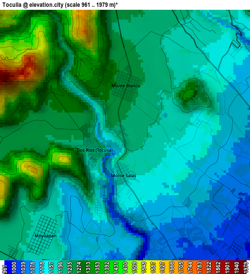
Below is the Elevation map of Tocuila, which displays elevation range with different colors. Scale of the first map is from 961 to 1979 m (3153 to 6493 ft) with average elevation of 1213 meters (=3980 ft) [note 1]
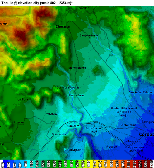
These maps also provides idea of topography and contour of this city, they are displayed at different zoom levels. More info about maps, scale and edge coordinates you can find below images.
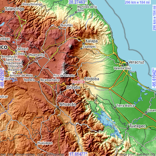
| \ | Map #1 | Map #2 | Topo.Map |
| Scale [m] | 961..1979 m | 802..2354 m | × |
| Scale [ft] | 3153..6493 ft | 2631..7723 ft | × |
| Average | 1213 m = 3980 ft | 1280.2 m = 4200 ft | × |
| Width | 9.24 km = 5.7 mi | 18.49 km = 11.5 mi | 295.7 km = 183.7 mi |
| Height | 9.24 km = 5.7 mi | 18.49 km = 11.5 mi | 295.8 km = 183.8 mi |
| ↑Max Latitude | 18.991558° | 19.033106° | 20.27463° |
| Latitude at center | 18.95° | 18.95° | 18.95° |
| ↓Min Latitude | 18.908431° | 18.866852° | 17.61477° |
| ← Min Longitude | -97.060615° | -97.104561° | -98.42292° |
| Longitude center | -97.01667° | -97.01667° | -97.01667° |
| →Max Longitude | -96.972725° | -96.928779° | -95.61042° |
Nearby cities:
Cities around Tocuila sort by population:
• Fortín de las Flores elevation 1048 m
5 km,  159°
159°
• Córdoba (Santa Leticia) 1010 m
6.1 km,  139°
139°
• Monte Blanco 1254 m
1.8 km,  359°
359°
• Dos Ríos 1220 m
1.3 km,  248°
248°
• Sumidero 1080 m
5.1 km,  185°
185°
• Moyoapan 1185 m
4.8 km,  219°
219°
• Monte Salas 1180 m
1.4 km, 187°
• San José Neria 1210 m
5.2 km,  20°
20°
• Santa Lucía Potrerillo 1292 m
2.3 km,  339°
339°
• Fraccionamiento Villas de la Llave 1048 m
4.7 km, 144°
• Fraccionamiento los Álamos 1024 m
5.2 km,  123°
123°
• San Isidro Palotal 1031 m
5.4 km,  96°
96°
Multilingual:
 En español:
Tocuila elevación 1221 m.
 En France:
Tocuila élévation 1221 m.
 Auf Deutsch:
Tocuila höhe über dem Meeresspiegel ist 1221 m.

Sources and notes:
- [note 1] Map square and city borders are not equal. Map elevation data is calculated only from area inside that square.
- [src 1] Elevation data from geonames database provided with same terms of usage.
- [src 2] The elevation map of Tocuila is generated using elevation data from NASA's 3 arcsec (90m) resolution SRTM data.
- [src 3] Base (background) map © OpenStreetMap contributors tiles are generated by Geofabrik and OpenTopoMap.
Copyright & License:
This Tocuila Elevation Map is licensed under CC BY-SA. You may reuse any part from this page, if you give a proper credit by linking to this URL:
 More info on terms of use page.