Excola elevation
Excola (Veracruz, Calcahualco), Mexico elevation is 2018 meters and Excola elevation in feet is 6621 ft above sea level [src 1]. Excola is a populated place (feature code) with elevation that is 704 meters (2310 ft) bigger than average city elevation in Mexico.
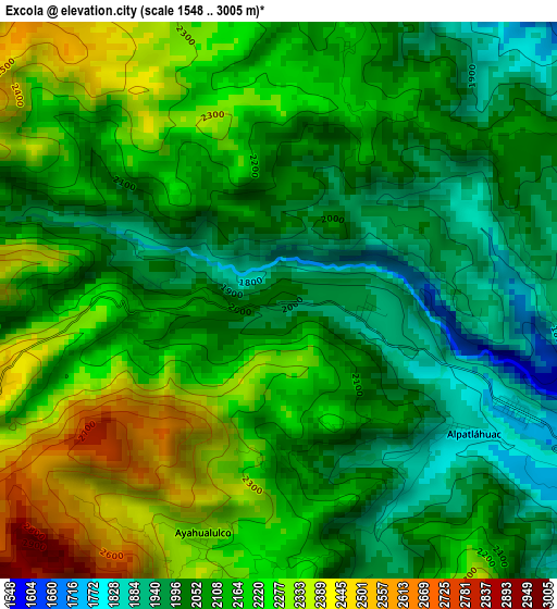
Below is the Elevation map of Excola, which displays elevation range with different colors. Scale of the first map is from 1548 to 3005 m (5079 to 9859 ft) with average elevation of 2130.6 meters (=6990 ft) [note 1]
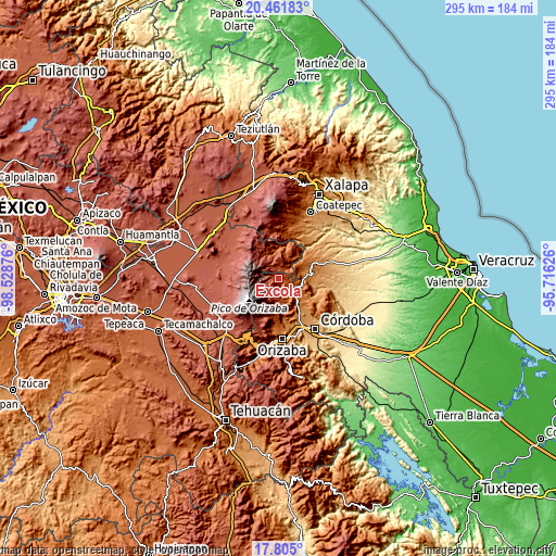
These maps also provides idea of topography and contour of this city, they are displayed at different zoom levels. More info about maps, scale and edge coordinates you can find below images.
| \ | Map #1 | Topo.Map |
| Scale [m] | 1548..3005 m | × |
| Scale [ft] | 5079..9859 ft | × |
| Average | 2130.6 m = 6990 ft | × |
| Width | 9.23 km = 5.7 mi | 295.4 km = 183.6 mi |
| Height | 9.23 km = 5.7 mi | 295.4 km = 183.6 mi |
| ↑Max Latitude | 19.180271° | 20.46183° |
| Latitude at center | 19.13876° | 19.13876° |
| ↓Min Latitude | 19.097238° | 17.805° |
| ← Min Longitude | -97.166455° | -98.52876° |
| Longitude center | -97.12251° | -97.12251° |
| →Max Longitude | -97.078565° | -95.71626° |
Nearby cities:
Cities around Excola sort by population:
• Teteltzingo elevation 2287 m
10 km,  193°
193°
• Chichiquila 1786 m
9 km,  40°
40°
• El Palmar 1848 m
7.3 km,  89°
89°
• Tozongo 1665 m
7.8 km,  123°
123°
• Tlanepantla 2394 m
8.8 km,  352°
352°
• Alpatláhuac 1855 m
3.7 km, 124°
• Ayahualulco 2330 m
4.1 km,  199°
199°
• Rincón de los Reyes 2399 m
7.4 km,  327°
327°
• Calcahualco 1792 m
4.3 km, 115°
• Nenehuaca 1841 m
8.5 km, 86°
• Xacaxomulco 2330 m
6.1 km,  335°
335°
• Cruz Verde 1943 m
1.5 km,  95°
95°
Multilingual:
 En español:
Excola elevación 2018 m.
 En France:
Excola élévation 2018 m.


Sources and notes:
- [note 1] Map square and city borders are not equal. Map elevation data is calculated only from area inside that square.
- [src 1] Elevation data from geonames database provided with same terms of usage.
- [src 2] The elevation map of Excola is generated using elevation data from NASA's 3 arcsec (90m) resolution SRTM data.
- [src 3] Base (background) map © OpenStreetMap contributors tiles are generated by Geofabrik and OpenTopoMap.
Copyright & License:
This Excola Elevation Map is licensed under CC BY-SA. You may reuse any part from this page, if you give a proper credit by linking to this URL:
 More info on terms of use page.