El Pedregal elevation
El Pedregal (Michoacán, Huiramba), Mexico elevation is 2208 meters and El Pedregal elevation in feet is 7244 ft above sea level [src 1]. El Pedregal is a populated place (feature code) with elevation that is 894 meters (2933 ft) bigger than average city elevation in Mexico.
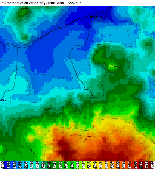
Below is the Elevation map of El Pedregal, which displays elevation range with different colors. Scale of the first map is from 2095 to 2823 m (6873 to 9262 ft) with average elevation of 2313.5 meters (=7590 ft) [note 1]
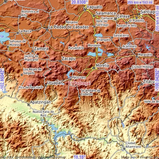
These maps also provides idea of topography and contour of this city, they are displayed at different zoom levels. More info about maps, scale and edge coordinates you can find below images.
| \ | Map #1 | Topo.Map |
| Scale [m] | 2095..2823 m | × |
| Scale [ft] | 6873..9262 ft | × |
| Average | 2313.5 m = 7590 ft | × |
| Width | 9.21 km = 5.7 mi | 294.7 km = 183.1 mi |
| Height | 9.21 km = 5.7 mi | 294.8 km = 183.2 mi |
| ↑Max Latitude | 19.552247° | 20.8308° |
| Latitude at center | 19.51083° | 19.51083° |
| ↓Min Latitude | 19.469403° | 18.18° |
| ← Min Longitude | -101.493115° | -102.85542° |
| Longitude center | -101.44917° | -101.44917° |
| →Max Longitude | -101.405225° | -100.04292° |
Nearby cities:
Cities around El Pedregal sort by population:
• Pátzcuaro elevation 2153 m
16.7 km,  271°
271°
• Acuítzio del Canje 2085 m
12.3 km,  97°
97°
• Cuanajo 2335 m
6.8 km,  244°
244°
• Ihuatzio 2057 m
18.6 km,  289°
289°
• Colonia Vista Bella (Lomas del Peaje) 2277 m
15.3 km,  261°
261°
• Huiramba 2108 m
4.1 km,  18°
18°
• Lagunillas 2110 m
6.7 km,  31°
31°
• Tirípetio 2016 m
11.5 km,  68°
68°
• Santa Juana 2485 m
14.8 km,  232°
232°
• San Gregorio 2684 m
15.3 km,  218°
218°
• San Juan de Viña 2286 m
18.8 km,  189°
189°
• Iratzio 2234 m
15.5 km,  14°
14°
Multilingual:
 En español:
El Pedregal elevación 2208 m.
 En France:
El Pedregal élévation 2208 m.
 Auf Deutsch:
El Pedregal höhe über dem Meeresspiegel ist 2208 m.

Sources and notes:
- [note 1] Map square and city borders are not equal. Map elevation data is calculated only from area inside that square.
- [src 1] Elevation data from geonames database provided with same terms of usage.
- [src 2] The elevation map of El Pedregal is generated using elevation data from NASA's 3 arcsec (90m) resolution SRTM data.
- [src 3] Base (background) map © OpenStreetMap contributors tiles are generated by Geofabrik and OpenTopoMap.
Copyright & License:
This El Pedregal Elevation Map is licensed under CC BY-SA. You may reuse any part from this page, if you give a proper credit by linking to this URL:
 More info on terms of use page.