Huiramba elevation
Huiramba (Michoacán), Mexico elevation is 2108 meters and Huiramba elevation in feet is 6916 ft above sea level [src 1]. Huiramba is a seat of a second-order administrative division (feature code) with elevation that is 794 meters (2605 ft) bigger than average city elevation in Mexico.
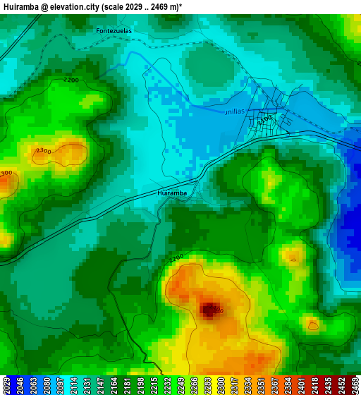
Below is the Elevation map of Huiramba, which displays elevation range with different colors. Scale of the first map is from 2029 to 2469 m (6657 to 8100 ft) with average elevation of 2175.3 meters (=7137 ft) [note 1]
These maps also provides idea of topography and contour of this city, they are displayed at different zoom levels. More info about maps, scale and edge coordinates you can find below images.
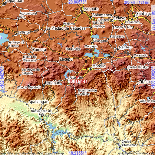
| \ | Map #1 | Topo.Map |
| Scale [m] | 2029..2469 m | × |
| Scale [ft] | 6657..8100 ft | × |
| Average | 2175.3 m = 7137 ft | × |
| Width | 9.21 km = 5.7 mi | 294.7 km = 183.1 mi |
| Height | 9.21 km = 5.7 mi | 294.7 km = 183.1 mi |
| ↑Max Latitude | 19.587468° | 20.86573° |
| Latitude at center | 19.54606° | 19.54606° |
| ↓Min Latitude | 19.504642° | 18.21551° |
| ← Min Longitude | -101.480455° | -102.84276° |
| Longitude center | -101.43651° | -101.43651° |
| →Max Longitude | -101.392565° | -100.03026° |
Nearby cities:
Cities around Huiramba sort by population:
• Quiroga elevation 2083 m
16.1 km,  325°
325°
• Acuítzio del Canje 2085 m
12.2 km,  117°
117°
• Capula 2098 m
14.9 km,  18°
18°
• Cuanajo 2335 m
10.1 km,  227°
227°
• Tzintzuntzán 2056 m
17.5 km,  301°
301°
• San Nicolás Obispo 1988 m
17.3 km,  46°
46°
• Lagunillas 2110 m
2.9 km, 49°
• Tirípetio 2016 m
9.4 km,  88°
88°
• Santiago Undameo 2045 m
16.8 km,  71°
71°
• Tacicuaro 2085 m
15.9 km,  30°
30°
• El Pedregal 2208 m
4.1 km,  198°
198°
• Iratzio 2234 m
11.4 km,  13°
13°
Multilingual:
 En español:
Huiramba elevación 2108 m.
 En France:
Huiramba élévation 2108 m.
 Auf Deutsch:
Huiramba höhe über dem Meeresspiegel ist 2108 m.

Sources and notes:
- [note 1] Map square and city borders are not equal. Map elevation data is calculated only from area inside that square.
- [src 1] Elevation data from geonames database provided with same terms of usage.
- [src 2] The elevation map of Huiramba is generated using elevation data from NASA's 3 arcsec (90m) resolution SRTM data.
- [src 3] Base (background) map © OpenStreetMap contributors tiles are generated by Geofabrik and OpenTopoMap.
Copyright & License:
This Huiramba Elevation Map is licensed under CC BY-SA. You may reuse any part from this page, if you give a proper credit by linking to this URL:
 More info on terms of use page.