Quiroga elevation
Quiroga (Michoacán), Mexico elevation is 2083 meters and Quiroga elevation in feet is 6834 ft above sea level [src 1]. Quiroga is a seat of a second-order administrative division (feature code) with elevation that is 769 meters (2523 ft) bigger than average city elevation in Mexico.
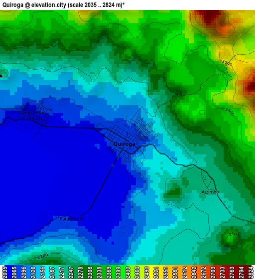
Below is the Elevation map of Quiroga, which displays elevation range with different colors. Scale of the first map is from 2035 to 2824 m (6677 to 9265 ft) with average elevation of 2218 meters (=7277 ft) [note 1]
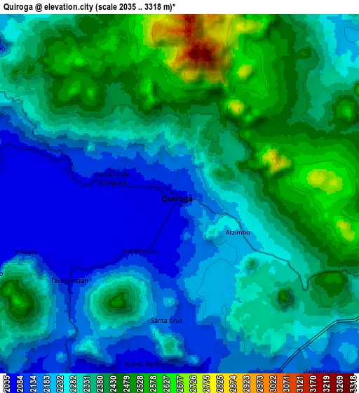
These maps also provides idea of topography and contour of this city, they are displayed at different zoom levels. More info about maps, scale and edge coordinates you can find below images.
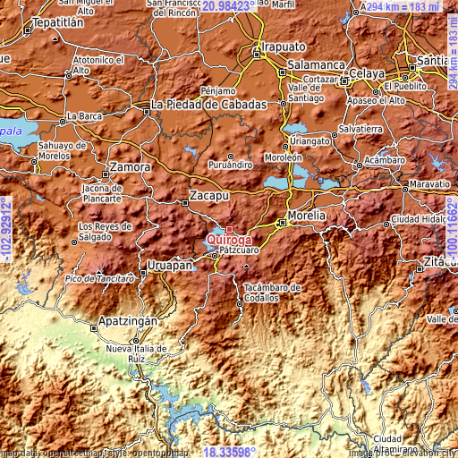
| \ | Map #1 | Map #2 | Topo.Map |
| Scale [m] | 2035..2824 m | 2035..3318 m | × |
| Scale [ft] | 6677..9265 ft | 6677..10886 ft | × |
| Average | 2218 m = 7277 ft | 2317.2 m = 7602 ft | × |
| Width | 9.2 km = 5.7 mi | 18.41 km = 11.4 mi | 294.5 km = 183 mi |
| Height | 9.2 km = 5.7 mi | 18.41 km = 11.4 mi | 294.5 km = 183 mi |
| ↑Max Latitude | 19.706947° | 19.748313° | 20.98423° |
| Latitude at center | 19.66557° | 19.66557° | 19.66557° |
| ↓Min Latitude | 19.624183° | 19.582784° | 18.33598° |
| ← Min Longitude | -101.566815° | -101.610761° | -102.92912° |
| Longitude center | -101.52287° | -101.52287° | -101.52287° |
| →Max Longitude | -101.478925° | -101.434979° | -100.11662° |
Nearby cities:
Cities around Quiroga sort by population:
• Capula elevation 2098 m
13.8 km,  86°
86°
• Santa Fé de la Laguna 2053 m
3.4 km,  283°
283°
• Ihuatzio 2057 m
14.7 km,  221°
221°
• Tzintzuntzán 2056 m
7.1 km,  234°
234°
• Huiramba 2108 m
16.1 km,  145°
145°
• Zipiajo 2141 m
14.7 km,  347°
347°
• Lagunillas 2110 m
16 km,  135°
135°
• San Andrés Ziróndaro 2052 m
11.5 km,  272°
272°
• San Jerónimo Purenchecuaro 2065 m
9.5 km, 279°
• Teremendo 2166 m
14.1 km,  18°
18°
• Cucuchucho 2060 m
14.6 km, 230°
• Iratzio 2234 m
11.8 km,  100°
100°
Multilingual:
 En español:
Quiroga elevación 2083 m.
 En France:
Quiroga élévation 2083 m.
 Auf Deutsch:
Quiroga höhe über dem Meeresspiegel ist 2083 m.

Sources and notes:
- [note 1] Map square and city borders are not equal. Map elevation data is calculated only from area inside that square.
- [src 1] Elevation data from geonames database provided with same terms of usage.
- [src 2] The elevation map of Quiroga is generated using elevation data from NASA's 3 arcsec (90m) resolution SRTM data.
- [src 3] Base (background) map © OpenStreetMap contributors tiles are generated by Geofabrik and OpenTopoMap.
Copyright & License:
This Quiroga Elevation Map is licensed under CC BY-SA. You may reuse any part from this page, if you give a proper credit by linking to this URL:
 More info on terms of use page.