Tzintzuntzán elevation
Tzintzuntzán (Michoacán, Tzintzuntzan), Mexico elevation is 2056 meters and Tzintzuntzán elevation in feet is 6745 ft above sea level [src 1]. Tzintzuntzán is a seat of a second-order administrative division (feature code) with elevation that is 742 meters (2434 ft) bigger than average city elevation in Mexico.
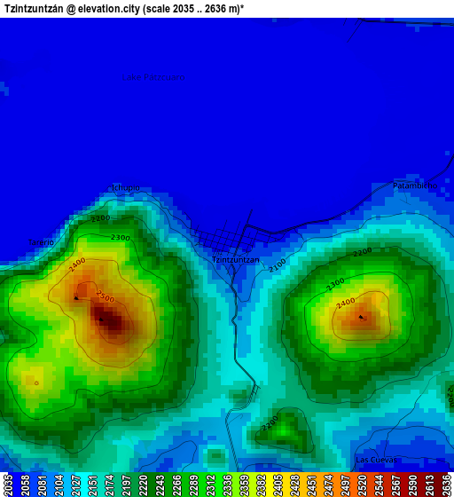
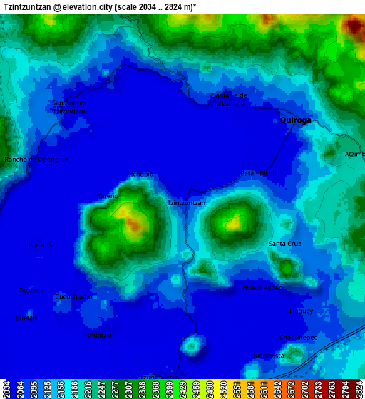
Below is the Elevation map of Tzintzuntzán, which displays elevation range with different colors. Scale of the first map is from 2035 to 2636 m (6677 to 8648 ft) with average elevation of 2143.7 meters (=7033 ft) [note 1]
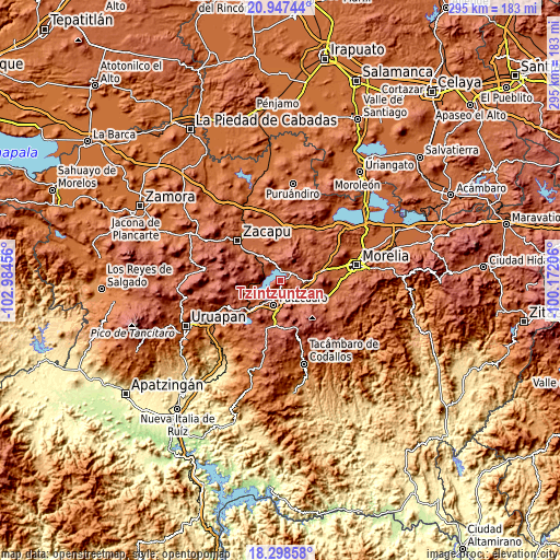
These maps also provides idea of topography and contour of this city, they are displayed at different zoom levels. More info about maps, scale and edge coordinates you can find below images.
| \ | Map #1 | Map #2 | Topo.Map |
| Scale [m] | 2035..2636 m | 2034..2824 m | × |
| Scale [ft] | 6677..8648 ft | 6673..9265 ft | × |
| Average | 2143.7 m = 7033 ft | 2140.5 m = 7023 ft | × |
| Width | 9.2 km = 5.7 mi | 18.41 km = 11.4 mi | 294.5 km = 183 mi |
| Height | 9.2 km = 5.7 mi | 18.41 km = 11.4 mi | 294.5 km = 183 mi |
| ↑Max Latitude | 19.669856° | 19.711232° | 20.94744° |
| Latitude at center | 19.62847° | 19.62847° | 19.62847° |
| ↓Min Latitude | 19.587073° | 19.545665° | 18.29858° |
| ← Min Longitude | -101.622255° | -101.666201° | -102.98456° |
| Longitude center | -101.57831° | -101.57831° | -101.57831° |
| →Max Longitude | -101.534365° | -101.490419° | -100.17206° |
Nearby cities:
Cities around Tzintzuntzán sort by population:
• Pátzcuaro elevation 2153 m
12.9 km,  194°
194°
• Quiroga 2083 m
7.1 km,  54°
54°
• Santa Fé de la Laguna 2053 m
5.5 km,  26°
26°
• Ihuatzio 2057 m
8 km,  210°
210°
• Jarácuaro 2069 m
12.9 km,  234°
234°
• Janitzio 2100 m
9.9 km, 231°
• San Andrés Ziróndaro 2052 m
7.3 km,  308°
308°
• Puácuaro 2073 m
10.4 km,  254°
254°
• San Jerónimo Purenchecuaro 2065 m
6.7 km,  327°
327°
• Santiago Azajo 2264 m
14.3 km, 307°
• Cucuchucho 2060 m
7.5 km, 227°
• Santa Ana Chapitiro 2063 m
13.8 km, 214°
Multilingual:
 En español:
Tzintzuntzán elevación 2056 m.
 En France:
Tzintzuntzán élévation 2056 m.
 Auf Deutsch:
Tzintzuntzán höhe über dem Meeresspiegel ist 2056 m.

Sources and notes:
- [note 1] Map square and city borders are not equal. Map elevation data is calculated only from area inside that square.
- [src 1] Elevation data from geonames database provided with same terms of usage.
- [src 2] The elevation map of Tzintzuntzán is generated using elevation data from NASA's 3 arcsec (90m) resolution SRTM data.
- [src 3] Base (background) map © OpenStreetMap contributors tiles are generated by Geofabrik and OpenTopoMap.
Copyright & License:
This Tzintzuntzán Elevation Map is licensed under CC BY-SA. You may reuse any part from this page, if you give a proper credit by linking to this URL:
 More info on terms of use page.