Pátzcuaro elevation
Pátzcuaro (Michoacán), Mexico elevation is 2153 meters and Pátzcuaro elevation in feet is 7064 ft above sea level [src 1]. Pátzcuaro is a seat of a second-order administrative division (feature code) with elevation that is 839 meters (2753 ft) bigger than average city elevation in Mexico.
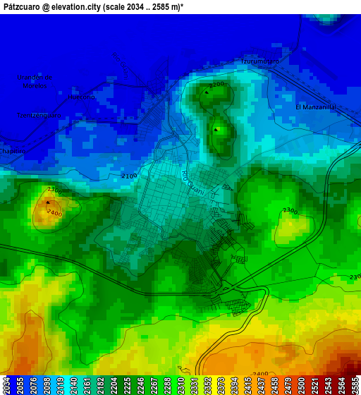
Below is the Elevation map of Pátzcuaro, which displays elevation range with different colors. Scale of the first map is from 2034 to 2585 m (6673 to 8481 ft) with average elevation of 2191.7 meters (=7191 ft) [note 1]
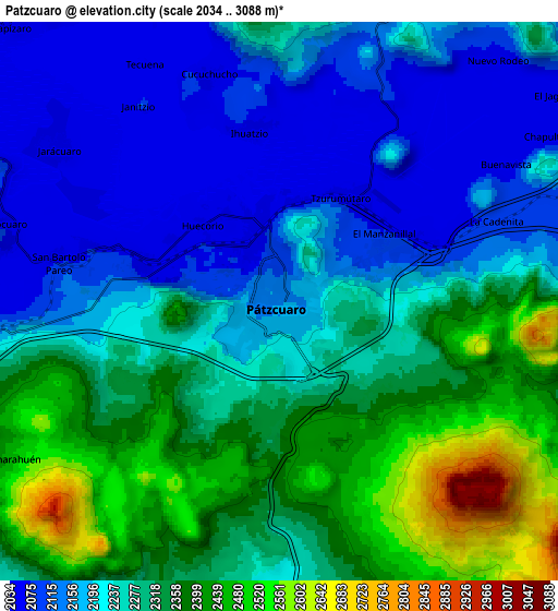
These maps also provides idea of topography and contour of this city, they are displayed at different zoom levels. More info about maps, scale and edge coordinates you can find below images.

| \ | Map #1 | Map #2 | Topo.Map |
| Scale [m] | 2034..2585 m | 2034..3088 m | × |
| Scale [ft] | 6673..8481 ft | 6673..10131 ft | × |
| Average | 2191.7 m = 7191 ft | 2261.7 m = 7420 ft | × |
| Width | 9.21 km = 5.7 mi | 18.42 km = 11.4 mi | 294.7 km = 183.1 mi |
| Height | 9.21 km = 5.7 mi | 18.42 km = 11.4 mi | 294.8 km = 183.2 mi |
| ↑Max Latitude | 19.557355° | 19.59876° | 20.83586° |
| Latitude at center | 19.51594° | 19.51594° | 19.51594° |
| ↓Min Latitude | 19.474514° | 19.433078° | 18.18515° |
| ← Min Longitude | -101.652815° | -101.696761° | -103.01512° |
| Longitude center | -101.60887° | -101.60887° | -101.60887° |
| →Max Longitude | -101.564925° | -101.520979° | -100.20262° |
Nearby cities:
Cities around Pátzcuaro sort by population:
• Santa Clara del Cobre elevation 2232 m
12.7 km,  194°
194°
• Opopeo 2249 m
11.6 km,  178°
178°
• Cuanajo 2335 m
11.1 km,  108°
108°
• Ihuatzio 2057 m
5.7 km,  351°
351°
• Colonia Vista Bella (Lomas del Peaje) 2277 m
3.2 km,  150°
150°
• Jarácuaro 2069 m
8.8 km,  304°
304°
• Janitzio 2100 m
7.8 km,  324°
324°
• Santa Juana 2485 m
10.8 km, 152°
• Puácuaro 2073 m
11.8 km, 324°
• Ajuno 2101 m
11.9 km,  268°
268°
• Cucuchucho 2060 m
7.8 km,  342°
342°
• Santa Ana Chapitiro 2063 m
4.7 km,  283°
283°
Multilingual:
 En español:
Pátzcuaro elevación 2153 m.
 En France:
Pátzcuaro élévation 2153 m.
 Auf Deutsch:
Pátzcuaro höhe über dem Meeresspiegel ist 2153 m.

Sources and notes:
- [note 1] Map square and city borders are not equal. Map elevation data is calculated only from area inside that square.
- [src 1] Elevation data from geonames database provided with same terms of usage.
- [src 2] The elevation map of Pátzcuaro is generated using elevation data from NASA's 3 arcsec (90m) resolution SRTM data.
- [src 3] Base (background) map © OpenStreetMap contributors tiles are generated by Geofabrik and OpenTopoMap.
Copyright & License:
This Pátzcuaro Elevation Map is licensed under CC BY-SA. You may reuse any part from this page, if you give a proper credit by linking to this URL:
 More info on terms of use page.