Teremendo elevation
Teremendo (State of Mexico), Mexico elevation is 2166 meters and Teremendo elevation in feet is 7106 ft above sea level [src 1]. Teremendo is a populated place (feature code) with elevation that is 852 meters (2795 ft) bigger than average city elevation in Mexico.
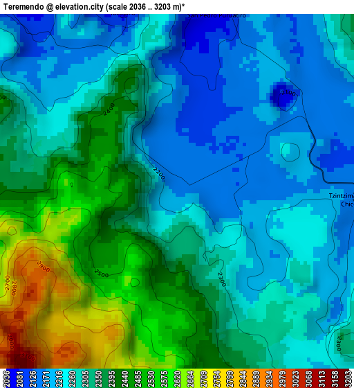
Below is the Elevation map of Teremendo, which displays elevation range with different colors. Scale of the first map is from 2036 to 3203 m (6680 to 10509 ft) with average elevation of 2330.8 meters (=7647 ft) [note 1]
These maps also provides idea of topography and contour of this city, they are displayed at different zoom levels. More info about maps, scale and edge coordinates you can find below images.
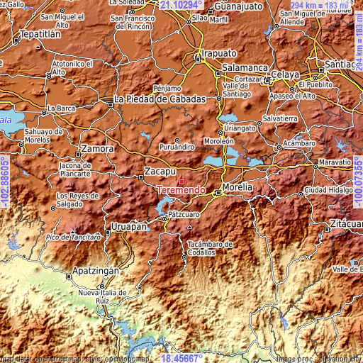
| \ | Map #1 | Topo.Map |
| Scale [m] | 2036..3203 m | × |
| Scale [ft] | 6680..10509 ft | × |
| Average | 2330.8 m = 7647 ft | × |
| Width | 9.2 km = 5.7 mi | 294.2 km = 182.8 mi |
| Height | 9.2 km = 5.7 mi | 294.3 km = 182.9 mi |
| ↑Max Latitude | 19.826646° | 21.10294° |
| Latitude at center | 19.7853° | 19.7853° |
| ↓Min Latitude | 19.743944° | 18.45667° |
| ← Min Longitude | -101.523745° | -102.88605° |
| Longitude center | -101.4798° | -101.4798° |
| →Max Longitude | -101.435855° | -100.07355° |
Nearby cities:
Cities around Teremendo sort by population:
• Quiroga elevation 2083 m
14.1 km,  198°
198°
• Capula 2098 m
15.5 km,  143°
143°
• Santa Fé de la Laguna 2053 m
14.8 km,  212°
212°
• Villa Magna 2015 m
19.6 km,  125°
125°
• Coeneo de la Libertad 2043 m
11.7 km,  290°
290°
• Huaniqueo de Morales 2049 m
12.7 km,  348°
348°
• Zipiajo 2141 m
7.7 km,  277°
277°
• Lomas de la Maestranza 2045 m
19.1 km,  124°
124°
• San Jerónimo Purenchecuaro 2065 m
18.2 km,  229°
229°
• Tacicuaro 2085 m
18 km, 135°
• Cuto de la Esperanza 2155 m
15.8 km,  112°
112°
• Iratzio 2234 m
17.1 km,  155°
155°
Multilingual:
 En español:
Teremendo elevación 2166 m.
 En France:
Teremendo élévation 2166 m.
 Auf Deutsch:
Teremendo höhe über dem Meeresspiegel ist 2166 m.

Sources and notes:
- [note 1] Map square and city borders are not equal. Map elevation data is calculated only from area inside that square.
- [src 1] Elevation data from geonames database provided with same terms of usage.
- [src 2] The elevation map of Teremendo is generated using elevation data from NASA's 3 arcsec (90m) resolution SRTM data.
- [src 3] Base (background) map © OpenStreetMap contributors tiles are generated by Geofabrik and OpenTopoMap.
Copyright & License:
This Teremendo Elevation Map is licensed under CC BY-SA. You may reuse any part from this page, if you give a proper credit by linking to this URL:
 More info on terms of use page.