Acuítzio del Canje elevation
Acuítzio del Canje (Michoacán, Acuitzio), Mexico elevation is 2085 meters and Acuítzio del Canje elevation in feet is 6841 ft above sea level [src 1]. Acuítzio del Canje is a seat of a second-order administrative division (feature code) with elevation that is 771 meters (2530 ft) bigger than average city elevation in Mexico.
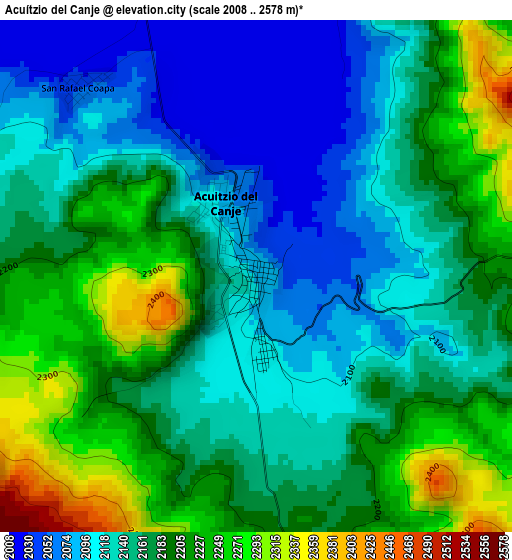
Below is the Elevation map of Acuítzio del Canje, which displays elevation range with different colors. Scale of the first map is from 2008 to 2578 m (6588 to 8458 ft) with average elevation of 2166.2 meters (=7107 ft) [note 1]
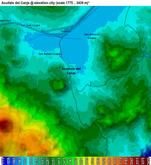
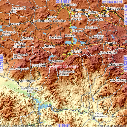
These maps also provides idea of topography and contour of this city, they are displayed at different zoom levels. More info about maps, scale and edge coordinates you can find below images.
| \ | Map #1 | Map #2 | Topo.Map |
| Scale [m] | 2008..2578 m | 1775..3439 m | × |
| Scale [ft] | 6588..8458 ft | 5823..11283 ft | × |
| Average | 2166.2 m = 7107 ft | 2272.1 m = 7454 ft | × |
| Width | 9.21 km = 5.7 mi | 18.42 km = 11.4 mi | 294.8 km = 183.2 mi |
| Height | 9.21 km = 5.7 mi | 18.42 km = 11.4 mi | 294.8 km = 183.2 mi |
| ↑Max Latitude | 19.53727° | 19.57868° | 20.81594° |
| Latitude at center | 19.49585° | 19.49585° | 19.49585° |
| ↓Min Latitude | 19.454419° | 19.412977° | 18.1649° |
| ← Min Longitude | -101.377155° | -101.421101° | -102.73946° |
| Longitude center | -101.33321° | -101.33321° | -101.33321° |
| →Max Longitude | -101.289265° | -101.245319° | -99.92696° |
Nearby cities:
Cities around Acuítzio del Canje sort by population:
• Villa Madero elevation 2188 m
12.9 km,  153°
153°
• Cuanajo 2335 m
18.4 km,  266°
266°
• Huiramba 2108 m
12.2 km,  297°
297°
• San Nicolás Obispo 1988 m
17.5 km,  6°
6°
• Lagunillas 2110 m
11.4 km,  310°
310°
• Tirípetio 2016 m
6.1 km,  346°
346°
• Santiago Undameo 2045 m
12.2 km,  24°
24°
• Tacicuaro 2085 m
19.5 km, 351°
• El Pedregal 2208 m
12.3 km,  277°
277°
• Etúcuaro 1579 m
15 km,  124°
124°
• La Mintzita (Piedra Dura) 1902 m
18.3 km, 18°
• Iratzio 2234 m
18.6 km,  333°
333°
Multilingual:
 En español:
Acuítzio del Canje elevación 2085 m.
 En France:
Acuítzio del Canje élévation 2085 m.
 Auf Deutsch:
Acuítzio del Canje höhe über dem Meeresspiegel ist 2085 m.
 На русском:
Acuítzio del Canje высота над уровнем моря 2085 м
Sources and notes:
- [note 1] Map square and city borders are not equal. Map elevation data is calculated only from area inside that square.
- [src 1] Elevation data from geonames database provided with same terms of usage.
- [src 2] The elevation map of Acuítzio del Canje is generated using elevation data from NASA's 3 arcsec (90m) resolution SRTM data.
- [src 3] Base (background) map © OpenStreetMap contributors tiles are generated by Geofabrik and OpenTopoMap.
Copyright & License:
This Acuítzio del Canje Elevation Map is licensed under CC BY-SA. You may reuse any part from this page, if you give a proper credit by linking to this URL:
 More info on terms of use page.