Villa Madero elevation
Villa Madero (Michoacán, Madero), Mexico elevation is 2188 meters and Villa Madero elevation in feet is 7178 ft above sea level [src 1]. Villa Madero is a populated place (feature code) with elevation that is 874 meters (2867 ft) bigger than average city elevation in Mexico.
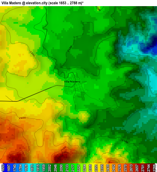
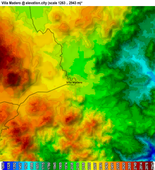
Below is the Elevation map of Villa Madero, which displays elevation range with different colors. Scale of the first map is from 1653 to 2788 m (5423 to 9147 ft) with average elevation of 2182.3 meters (=7160 ft) [note 1]
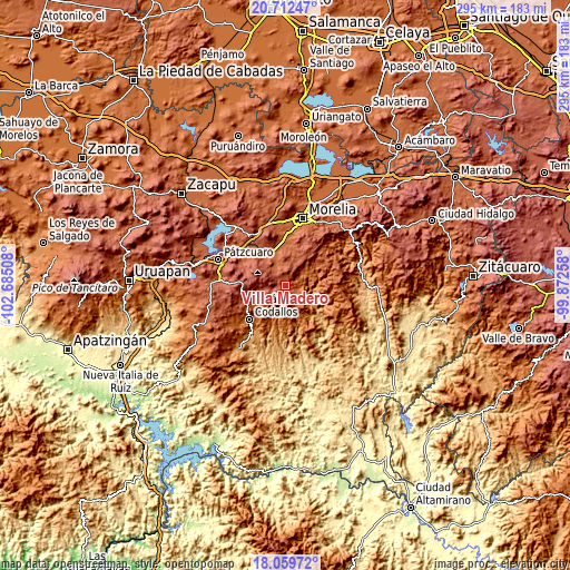
These maps also provides idea of topography and contour of this city, they are displayed at different zoom levels. More info about maps, scale and edge coordinates you can find below images.
| \ | Map #1 | Map #2 | Topo.Map |
| Scale [m] | 1653..2788 m | 1263..2943 m | × |
| Scale [ft] | 5423..9147 ft | 4144..9656 ft | × |
| Average | 2182.3 m = 7160 ft | 2180.6 m = 7154 ft | × |
| Width | 9.22 km = 5.7 mi | 18.44 km = 11.5 mi | 295 km = 183.3 mi |
| Height | 9.22 km = 5.7 mi | 18.44 km = 11.5 mi | 295 km = 183.3 mi |
| ↑Max Latitude | 19.432947° | 19.474384° | 20.71247° |
| Latitude at center | 19.3915° | 19.3915° | 19.3915° |
| ↓Min Latitude | 19.350042° | 19.308574° | 18.05972° |
| ← Min Longitude | -101.322775° | -101.366721° | -102.68508° |
| Longitude center | -101.27883° | -101.27883° | -101.27883° |
| →Max Longitude | -101.234885° | -101.190939° | -99.87258° |
Nearby cities:
Cities around Villa Madero sort by population:
• Tacámbaro de Codallos elevation 1656 m
25.6 km,  227°
227°
• Morelos 1950 m
28.9 km,  8°
8°
• Acuítzio del Canje 2085 m
12.9 km,  333°
333°
• Cuanajo 2335 m
26.2 km,  293°
293°
• Huiramba 2108 m
23.8 km,  316°
316°
• Lagunillas 2110 m
23.8 km, 322°
• Tirípetio 2016 m
18.9 km,  337°
337°
• Santiago Undameo 2045 m
22.7 km,  358°
358°
• San Gregorio 2684 m
27.3 km,  272°
272°
• El Pedregal 2208 m
22.2 km,  306°
306°
• Etúcuaro 1579 m
7.3 km,  64°
64°
• San Juan de Viña 2286 m
21.6 km,  255°
255°
Multilingual:
 En español:
Villa Madero elevación 2188 m.
 En France:
Villa Madero élévation 2188 m.
 Auf Deutsch:
Villa Madero höhe über dem Meeresspiegel ist 2188 m.

Sources and notes:
- [note 1] Map square and city borders are not equal. Map elevation data is calculated only from area inside that square.
- [src 1] Elevation data from geonames database provided with same terms of usage.
- [src 2] The elevation map of Villa Madero is generated using elevation data from NASA's 3 arcsec (90m) resolution SRTM data.
- [src 3] Base (background) map © OpenStreetMap contributors tiles are generated by Geofabrik and OpenTopoMap.
Copyright & License:
This Villa Madero Elevation Map is licensed under CC BY-SA. You may reuse any part from this page, if you give a proper credit by linking to this URL:
 More info on terms of use page.