San Juan de Viña elevation
San Juan de Viña (Michoacán, Tacámbaro), Mexico elevation is 2286 meters and San Juan de Viña elevation in feet is 7500 ft above sea level [src 1]. San Juan de Viña is a populated place (feature code) with elevation that is 972 meters (3189 ft) bigger than average city elevation in Mexico.
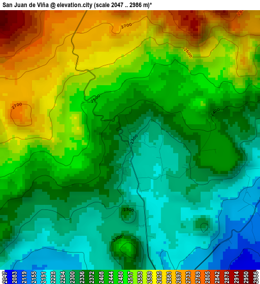
Below is the Elevation map of San Juan de Viña, which displays elevation range with different colors. Scale of the first map is from 2047 to 2986 m (6716 to 9797 ft) with average elevation of 2430.8 meters (=7975 ft) [note 1]
These maps also provides idea of topography and contour of this city, they are displayed at different zoom levels. More info about maps, scale and edge coordinates you can find below images.
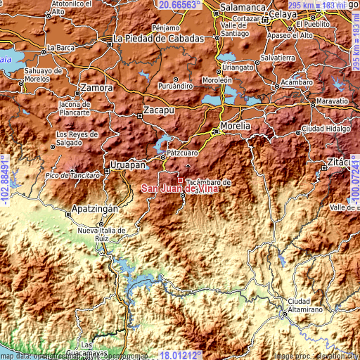
| \ | Map #1 | Topo.Map |
| Scale [m] | 2047..2986 m | × |
| Scale [ft] | 6716..9797 ft | × |
| Average | 2430.8 m = 7975 ft | × |
| Width | 9.22 km = 5.7 mi | 295 km = 183.3 mi |
| Height | 9.22 km = 5.7 mi | 295.1 km = 183.4 mi |
| ↑Max Latitude | 19.385729° | 20.66563° |
| Latitude at center | 19.34427° | 19.34427° |
| ↓Min Latitude | 19.3028° | 18.01212° |
| ← Min Longitude | -101.522605° | -102.88491° |
| Longitude center | -101.47866° | -101.47866° |
| →Max Longitude | -101.434715° | -100.07241° |
Nearby cities:
Cities around San Juan de Viña sort by population:
• Tacámbaro de Codallos elevation 1656 m
12.3 km,  169°
169°
• Santa Clara del Cobre 2232 m
18.3 km,  292°
292°
• Opopeo 2249 m
15.2 km,  299°
299°
• Cuanajo 2335 m
15.9 km,  348°
348°
• Colonia Vista Bella (Lomas del Peaje) 2277 m
20.3 km,  323°
323°
• Tecario 1798 m
14.2 km,  209°
209°
• Chupio 1179 m
18.8 km, 169°
• Santa Juana 2485 m
12.9 km, 317°
• San Gregorio 2684 m
9.1 km, 315°
• El Pedregal 2208 m
18.8 km,  9°
9°
• Chapa 2308 m
20 km,  281°
281°
• San Rafael Tecario 1538 m
15.1 km,  191°
191°
Multilingual:
 En español:
San Juan de Viña elevación 2286 m.
 En France:
San Juan de Viña élévation 2286 m.
 Auf Deutsch:
San Juan de Viña höhe über dem Meeresspiegel ist 2286 m.

Sources and notes:
- [note 1] Map square and city borders are not equal. Map elevation data is calculated only from area inside that square.
- [src 1] Elevation data from geonames database provided with same terms of usage.
- [src 2] The elevation map of San Juan de Viña is generated using elevation data from NASA's 3 arcsec (90m) resolution SRTM data.
- [src 3] Base (background) map © OpenStreetMap contributors tiles are generated by Geofabrik and OpenTopoMap.
Copyright & License:
This San Juan de Viña Elevation Map is licensed under CC BY-SA. You may reuse any part from this page, if you give a proper credit by linking to this URL:
 More info on terms of use page.