Tecario elevation
Tecario (Michoacán, Tacámbaro), Mexico elevation is 1798 meters and Tecario elevation in feet is 5899 ft above sea level [src 1]. Tecario is a populated place (feature code) with elevation that is 484 meters (1588 ft) bigger than average city elevation in Mexico.
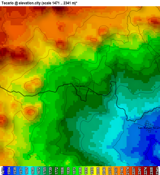
Below is the Elevation map of Tecario, which displays elevation range with different colors. Scale of the first map is from 1471 to 2341 m (4826 to 7680 ft) with average elevation of 1882.7 meters (=6177 ft) [note 1]
These maps also provides idea of topography and contour of this city, they are displayed at different zoom levels. More info about maps, scale and edge coordinates you can find below images.
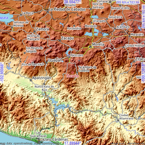
| \ | Map #1 | Topo.Map |
| Scale [m] | 1471..2341 m | × |
| Scale [ft] | 4826..7680 ft | × |
| Average | 1882.7 m = 6177 ft | × |
| Width | 9.23 km = 5.7 mi | 295.2 km = 183.4 mi |
| Height | 9.23 km = 5.7 mi | 295.3 km = 183.5 mi |
| ↑Max Latitude | 19.273957° | 20.55477° |
| Latitude at center | 19.23247° | 19.23247° |
| ↓Min Latitude | 19.190972° | 17.89944° |
| ← Min Longitude | -101.588375° | -102.95068° |
| Longitude center | -101.54443° | -101.54443° |
| →Max Longitude | -101.500485° | -100.13818° |
Nearby cities:
Cities around Tecario sort by population:
• Tacámbaro de Codallos elevation 1656 m
9.1 km,  88°
88°
• Ario de Rosales 1916 m
17.3 km,  261°
261°
• Puruarán 1117 m
15.3 km,  171°
171°
• Pedernales 1044 m
12.9 km,  141°
141°
• La Ermita (Nueva Jerusalén) 1154 m
18 km, 167°
• Chupio 1179 m
12 km,  120°
120°
• El Cahulote de Santa Ana 1410 m
17.8 km,  192°
192°
• Parahuén 2253 m
20.4 km,  310°
310°
• San Gregorio 2684 m
18.9 km,  1°
1°
• Tavera 1270 m
19.1 km,  184°
184°
• San Juan de Viña 2286 m
14.2 km,  29°
29°
• San Rafael Tecario 1538 m
4.7 km, 121°
Multilingual:
 En español:
Tecario elevación 1798 m.
 En France:
Tecario élévation 1798 m.
 Auf Deutsch:
Tecario höhe über dem Meeresspiegel ist 1798 m.

Sources and notes:
- [note 1] Map square and city borders are not equal. Map elevation data is calculated only from area inside that square.
- [src 1] Elevation data from geonames database provided with same terms of usage.
- [src 2] The elevation map of Tecario is generated using elevation data from NASA's 3 arcsec (90m) resolution SRTM data.
- [src 3] Base (background) map © OpenStreetMap contributors tiles are generated by Geofabrik and OpenTopoMap.
Copyright & License:
This Tecario Elevation Map is licensed under CC BY-SA. You may reuse any part from this page, if you give a proper credit by linking to this URL:
 More info on terms of use page.