El Mirador elevation
El Mirador (Puebla, Ixtacamaxtitlán), Mexico elevation is 2789 meters and El Mirador elevation in feet is 9150 ft above sea level [src 1]. El Mirador is a populated place (feature code) with elevation that is 1475 meters (4839 ft) bigger than average city elevation in Mexico.
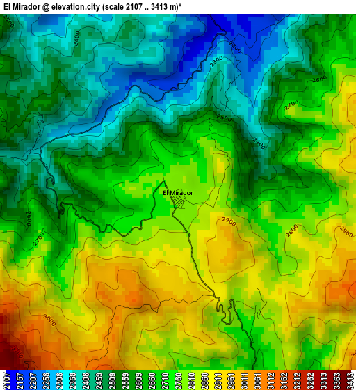
Below is the Elevation map of El Mirador, which displays elevation range with different colors. Scale of the first map is from 2107 to 3413 m (6913 to 11198 ft) with average elevation of 2674.4 meters (=8774 ft) [note 1]
These maps also provides idea of topography and contour of this city, they are displayed at different zoom levels. More info about maps, scale and edge coordinates you can find below images.
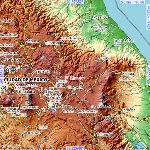
| \ | Map #1 | Topo.Map |
| Scale [m] | 2107..3413 m | × |
| Scale [ft] | 6913..11198 ft | × |
| Average | 2674.4 m = 8774 ft | × |
| Width | 9.21 km = 5.7 mi | 294.7 km = 183.1 mi |
| Height | 9.21 km = 5.7 mi | 294.7 km = 183.1 mi |
| ↑Max Latitude | 19.598345° | 20.87652° |
| Latitude at center | 19.55694° | 19.55694° |
| ↓Min Latitude | 19.515525° | 18.22648° |
| ← Min Longitude | -97.815885° | -99.17819° |
| Longitude center | -97.77194° | -97.77194° |
| →Max Longitude | -97.727995° | -96.36569° |
Nearby cities:
Cities around El Mirador sort by population:
• Libres elevation 2394 m
13.5 km,  138°
138°
• Atlzayanca 2603 m
14.2 km,  190°
190°
• Altzayanca 2603 m
14.2 km, 190°
• Temextla 2450 m
12.4 km,  62°
62°
• Guadalupe Victoria 2436 m
11.7 km,  88°
88°
• San José Villarreal 3077 m
13.4 km,  258°
258°
• Progreso 2391 m
12.5 km,  127°
127°
• La Unión Ejido Mexcaltepec 2510 m
8.6 km,  48°
48°
• Ocotepec 2465 m
12.7 km, 90°
• La Cañada 2578 m
7.6 km,  148°
148°
• San Andrés Yahuitlalpan 2034 m
13.8 km,  20°
20°
• Ixtacamaxtitlán 2117 m
8.7 km,  328°
328°
Multilingual:
 En español:
El Mirador elevación 2789 m.
 En France:
El Mirador élévation 2789 m.
 Auf Deutsch:
El Mirador höhe über dem Meeresspiegel ist 2789 m.

Sources and notes:
- [note 1] Map square and city borders are not equal. Map elevation data is calculated only from area inside that square.
- [src 1] Elevation data from geonames database provided with same terms of usage.
- [src 2] The elevation map of El Mirador is generated using elevation data from NASA's 3 arcsec (90m) resolution SRTM data.
- [src 3] Base (background) map © OpenStreetMap contributors tiles are generated by Geofabrik and OpenTopoMap.
Copyright & License:
This El Mirador Elevation Map is licensed under CC BY-SA. You may reuse any part from this page, if you give a proper credit by linking to this URL:
 More info on terms of use page.