Libres elevation
Libres (Puebla), Mexico elevation is 2394 meters and Libres elevation in feet is 7854 ft above sea level [src 1]. Libres is a seat of a second-order administrative division (feature code) with elevation that is 1080 meters (3543 ft) bigger than average city elevation in Mexico.
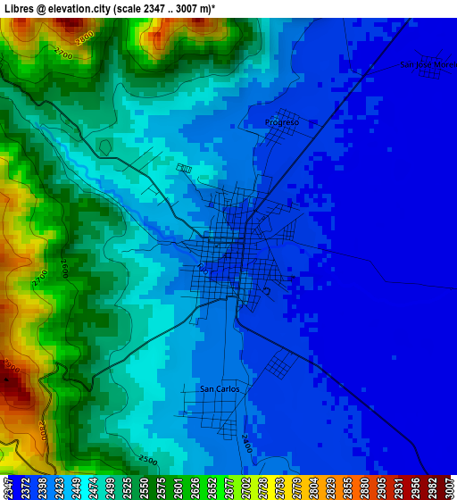
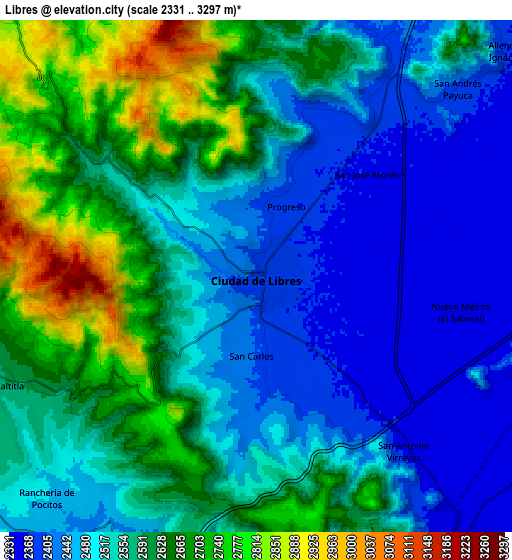
Below is the Elevation map of Libres, which displays elevation range with different colors. Scale of the first map is from 2347 to 3007 m (7700 to 9865 ft) with average elevation of 2466.9 meters (=8094 ft) [note 1]
These maps also provides idea of topography and contour of this city, they are displayed at different zoom levels. More info about maps, scale and edge coordinates you can find below images.
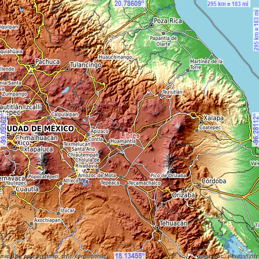
| \ | Map #1 | Map #2 | Topo.Map |
| Scale [m] | 2347..3007 m | 2331..3297 m | × |
| Scale [ft] | 7700..9865 ft | 7648..10817 ft | × |
| Average | 2466.9 m = 8094 ft | 2555.1 m = 8383 ft | × |
| Width | 9.21 km = 5.7 mi | 18.43 km = 11.5 mi | 294.8 km = 183.2 mi |
| Height | 9.21 km = 5.7 mi | 18.43 km = 11.5 mi | 294.8 km = 183.2 mi |
| ↑Max Latitude | 19.507168° | 19.548586° | 20.78609° |
| Latitude at center | 19.46574° | 19.46574° | 19.46574° |
| ↓Min Latitude | 19.424301° | 19.382852° | 18.13455° |
| ← Min Longitude | -97.731315° | -97.775261° | -99.09362° |
| Longitude center | -97.68737° | -97.68737° | -97.68737° |
| →Max Longitude | -97.643425° | -97.599479° | -96.28112° |
Nearby cities:
Cities around Libres sort by population:
• Oriental elevation 2354 m
12.2 km,  144°
144°
• Atlzayanca 2603 m
12 km,  251°
251°
• San Andrés Payuca 2392 m
9.9 km,  47°
47°
• Altzayanca 2603 m
12 km, 251°
• San Carlos 2408 m
3 km,  185°
185°
• Nuevo México 2349 m
7.4 km,  99°
99°
• San Antonio Virreyes 2365 m
8.2 km, 139°
• Guadalupe Victoria 2436 m
10.8 km,  15°
15°
• Progreso 2391 m
2.7 km, 22°
• Ranchería de Pocitos 2472 m
11 km,  223°
223°
• Ocotepec 2465 m
10.7 km, 21°
• La Cañada 2578 m
6.1 km,  307°
307°
Multilingual:
 En español:
Libres elevación 2394 m.
 En France:
Libres élévation 2394 m.


Sources and notes:
- [note 1] Map square and city borders are not equal. Map elevation data is calculated only from area inside that square.
- [src 1] Elevation data from geonames database provided with same terms of usage.
- [src 2] The elevation map of Libres is generated using elevation data from NASA's 3 arcsec (90m) resolution SRTM data.
- [src 3] Base (background) map © OpenStreetMap contributors tiles are generated by Geofabrik and OpenTopoMap.
Copyright & License:
This Libres Elevation Map is licensed under CC BY-SA. You may reuse any part from this page, if you give a proper credit by linking to this URL:
 More info on terms of use page.