Oriental elevation
Oriental (Puebla), Mexico elevation is 2354 meters and Oriental elevation in feet is 7723 ft above sea level [src 1]. Oriental is a populated place (feature code) with elevation that is 1040 meters (3412 ft) bigger than average city elevation in Mexico.
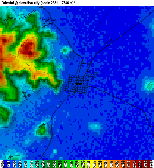
Below is the Elevation map of Oriental, which displays elevation range with different colors. Scale of the first map is from 2331 to 2786 m (7648 to 9140 ft) with average elevation of 2388.9 meters (=7838 ft) [note 1]
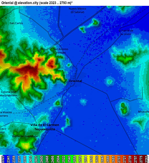
These maps also provides idea of topography and contour of this city, they are displayed at different zoom levels. More info about maps, scale and edge coordinates you can find below images.
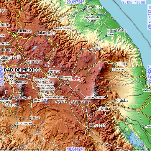
| \ | Map #1 | Map #2 | Topo.Map |
| Scale [m] | 2331..2786 m | 2323..2793 m | × |
| Scale [ft] | 7648..9140 ft | 7621..9163 ft | × |
| Average | 2388.9 m = 7838 ft | 2395.7 m = 7860 ft | × |
| Width | 9.22 km = 5.7 mi | 18.44 km = 11.5 mi | 295 km = 183.3 mi |
| Height | 9.22 km = 5.7 mi | 18.44 km = 11.5 mi | 295 km = 183.3 mi |
| ↑Max Latitude | 19.417591° | 19.459031° | 20.69724° |
| Latitude at center | 19.37614° | 19.37614° | 19.37614° |
| ↓Min Latitude | 19.334678° | 19.293206° | 18.04424° |
| ← Min Longitude | -97.664455° | -97.708401° | -99.02676° |
| Longitude center | -97.62051° | -97.62051° | -97.62051° |
| →Max Longitude | -97.576565° | -97.532619° | -96.21426° |
Nearby cities:
Cities around Oriental sort by population:
• Libres elevation 2394 m
12.2 km,  324°
324°
• Villa de El Carmen Tequexquitla 2363 m
6.7 km,  210°
210°
• Emilio Portes Gil 2396 m
13.9 km,  123°
123°
• El Fuerte de la Unión 2341 m
8.7 km,  45°
45°
• San Carlos 2408 m
10.1 km,  313°
313°
• Nuevo México 2349 m
8.8 km,  2°
2°
• San Antonio Virreyes 2365 m
4.1 km,  335°
335°
• Santa Cruz Pocitos 2456 m
14.8 km,  271°
271°
• Progreso 2391 m
13.8 km,  334°
334°
• Ranchería de Pocitos 2472 m
14.7 km,  277°
277°
• Miravalles 2392 m
9.4 km,  114°
114°
• San Francisco Cuexcontzi 2432 m
11.3 km,  236°
236°
Multilingual:
 En español:
Oriental elevación 2354 m.
 En France:
Oriental élévation 2354 m.
 Auf Deutsch:
Oriental höhe über dem Meeresspiegel ist 2354 m.

Sources and notes:
- [note 1] Map square and city borders are not equal. Map elevation data is calculated only from area inside that square.
- [src 1] Elevation data from geonames database provided with same terms of usage.
- [src 2] The elevation map of Oriental is generated using elevation data from NASA's 3 arcsec (90m) resolution SRTM data.
- [src 3] Base (background) map © OpenStreetMap contributors tiles are generated by Geofabrik and OpenTopoMap.
Copyright & License:
This Oriental Elevation Map is licensed under CC BY-SA. You may reuse any part from this page, if you give a proper credit by linking to this URL:
 More info on terms of use page.