Atlzayanca elevation
Atlzayanca (Tlaxcala, Atltzayanca), Mexico elevation is 2603 meters and Atlzayanca elevation in feet is 8540 ft above sea level [src 1]. Atlzayanca is a populated place (feature code) with elevation that is 1289 meters (4229 ft) bigger than average city elevation in Mexico.
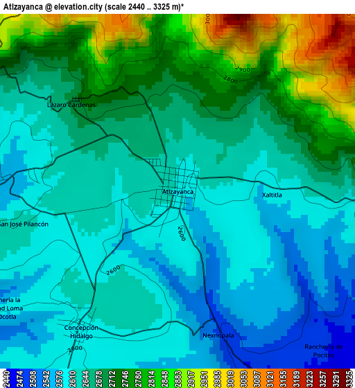
Below is the Elevation map of Atlzayanca, which displays elevation range with different colors. Scale of the first map is from 2440 to 3325 m (8005 to 10909 ft) with average elevation of 2668.6 meters (=8755 ft) [note 1]
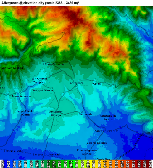
These maps also provides idea of topography and contour of this city, they are displayed at different zoom levels. More info about maps, scale and edge coordinates you can find below images.
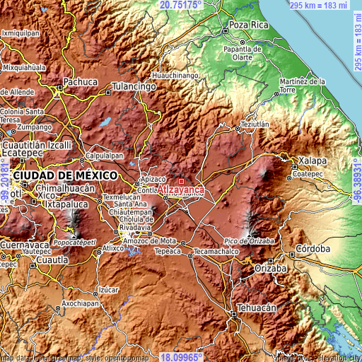
| \ | Map #1 | Map #2 | Topo.Map |
| Scale [m] | 2440..3325 m | 2386..3439 m | × |
| Scale [ft] | 8005..10909 ft | 7828..11283 ft | × |
| Average | 2668.6 m = 8755 ft | 2691.4 m = 8830 ft | × |
| Width | 9.22 km = 5.7 mi | 18.43 km = 11.5 mi | 294.9 km = 183.2 mi |
| Height | 9.22 km = 5.7 mi | 18.43 km = 11.5 mi | 294.9 km = 183.2 mi |
| ↑Max Latitude | 19.472547° | 19.513973° | 20.75175° |
| Latitude at center | 19.43111° | 19.43111° | 19.43111° |
| ↓Min Latitude | 19.389662° | 19.348204° | 18.09965° |
| ← Min Longitude | -97.839505° | -97.883451° | -99.20181° |
| Longitude center | -97.79556° | -97.79556° | -97.79556° |
| →Max Longitude | -97.751615° | -97.707669° | -96.38931° |
Nearby cities:
Cities around Atlzayanca sort by population:
• Libres elevation 2394 m
12 km,  71°
71°
• San José Xicohténcatl 2455 m
9.3 km,  203°
203°
• Benito Juárez 2447 m
13.5 km,  241°
241°
• Altzayanca 2603 m
0 km,  5°
5°
• Concepción Hidalgo 2602 m
4.4 km,  214°
214°
• San Carlos 2408 m
11.1 km,  85°
85°
• Colonia Ignacio Allende 2502 m
8.4 km,  171°
171°
• Santa Cruz Pocitos 2456 m
6.8 km,  147°
147°
• Progreso 2391 m
13.9 km,  62°
62°
• Ranchería de Pocitos 2472 m
5.6 km,  137°
137°
• Felipe Carrillo Puerto 2496 m
7.2 km, 240°
• La Cañada 2578 m
9.9 km,  40°
40°
Multilingual:
 En español:
Atlzayanca elevación 2603 m.
 En France:
Atlzayanca élévation 2603 m.
 Auf Deutsch:
Atlzayanca höhe über dem Meeresspiegel ist 2603 m.

Sources and notes:
- [note 1] Map square and city borders are not equal. Map elevation data is calculated only from area inside that square.
- [src 1] Elevation data from geonames database provided with same terms of usage.
- [src 2] The elevation map of Atlzayanca is generated using elevation data from NASA's 3 arcsec (90m) resolution SRTM data.
- [src 3] Base (background) map © OpenStreetMap contributors tiles are generated by Geofabrik and OpenTopoMap.
Copyright & License:
This Atlzayanca Elevation Map is licensed under CC BY-SA. You may reuse any part from this page, if you give a proper credit by linking to this URL:
 More info on terms of use page.