Benito Juárez elevation
Benito Juárez (Tlaxcala, Huamantla), Mexico elevation is 2447 meters and Benito Juárez elevation in feet is 8028 ft above sea level [src 1]. Benito Juárez is a populated place (feature code) with elevation that is 1133 meters (3717 ft) bigger than average city elevation in Mexico.
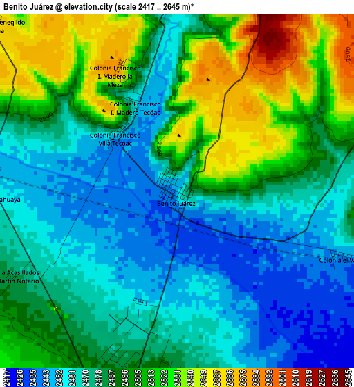
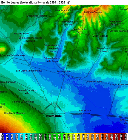
Below is the Elevation map of Benito Juárez, which displays elevation range with different colors. Scale of the first map is from 2417 to 2645 m (7930 to 8678 ft) with average elevation of 2487.3 meters (=8160 ft) [note 1]
These maps also provides idea of topography and contour of this city, they are displayed at different zoom levels. More info about maps, scale and edge coordinates you can find below images.
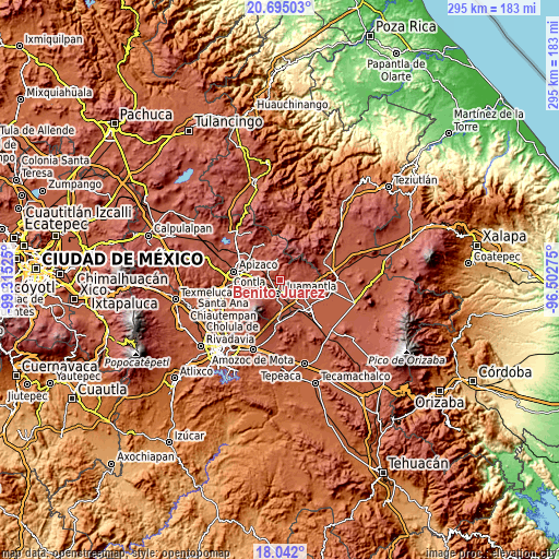
| \ | Map #1 | Map #2 | Topo.Map |
| Scale [m] | 2417..2645 m | 2390..2926 m | × |
| Scale [ft] | 7930..8678 ft | 7841..9600 ft | × |
| Average | 2487.3 m = 8160 ft | 2529.4 m = 8299 ft | × |
| Width | 9.22 km = 5.7 mi | 18.44 km = 11.5 mi | 295 km = 183.3 mi |
| Height | 9.22 km = 5.7 mi | 18.44 km = 11.5 mi | 295 km = 183.3 mi |
| ↑Max Latitude | 19.415362° | 19.456803° | 20.69503° |
| Latitude at center | 19.37391° | 19.37391° | 19.37391° |
| ↓Min Latitude | 19.332448° | 19.290975° | 18.042° |
| ← Min Longitude | -97.952945° | -97.996891° | -99.31525° |
| Longitude center | -97.909° | -97.909° | -97.909° |
| →Max Longitude | -97.865055° | -97.821109° | -96.50275° |
Nearby cities:
Cities around Benito Juárez sort by population:
• Huamantla elevation 2519 m
6.8 km,  194°
194°
• Ignacio Zaragoza 2531 m
9.2 km, 188°
• San José Xicohténcatl 2455 m
8.5 km,  104°
104°
• Terrenate 2677 m
11.5 km,  354°
354°
• Toluca de Guadalupe 2656 m
11.7 km,  335°
335°
• Concepción Hidalgo 2602 m
9.8 km,  74°
74°
• El Carmen Xalpatlahuaya 2501 m
7.9 km,  284°
284°
• Nicolás Bravo 2518 m
8.2 km,  311°
311°
• Lázaro Cárdenas 2525 m
8.4 km,  258°
258°
• José María Morelos 2652 m
9.6 km,  229°
229°
• Felipe Carrillo Puerto 2496 m
6.3 km,  63°
63°
• Colonia Cuauhtémoc 2560 m
7.5 km, 231°
Multilingual:
 En español:
Benito Juárez elevación 2447 m.
 En France:
Benito Juárez élévation 2447 m.
 Auf Deutsch:
Benito Juárez höhe über dem Meeresspiegel ist 2447 m.

Sources and notes:
- [note 1] Map square and city borders are not equal. Map elevation data is calculated only from area inside that square.
- [src 1] Elevation data from geonames database provided with same terms of usage.
- [src 2] The elevation map of Benito Juárez is generated using elevation data from NASA's 3 arcsec (90m) resolution SRTM data.
- [src 3] Base (background) map © OpenStreetMap contributors tiles are generated by Geofabrik and OpenTopoMap.
Copyright & License:
This Benito Juárez Elevation Map is licensed under CC BY-SA. You may reuse any part from this page, if you give a proper credit by linking to this URL:
 More info on terms of use page.