Terrenate elevation
Terrenate (Tlaxcala), Mexico elevation is 2677 meters and Terrenate elevation in feet is 8783 ft above sea level [src 1]. Terrenate is a seat of a second-order administrative division (feature code) with elevation that is 1363 meters (4472 ft) bigger than average city elevation in Mexico.
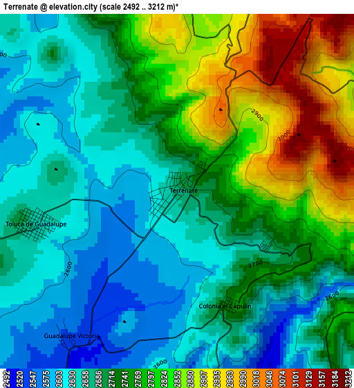
Below is the Elevation map of Terrenate, which displays elevation range with different colors. Scale of the first map is from 2492 to 3212 m (8176 to 10538 ft) with average elevation of 2728.5 meters (=8952 ft) [note 1]
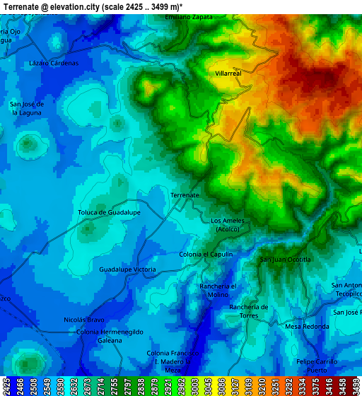
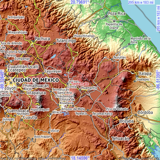
These maps also provides idea of topography and contour of this city, they are displayed at different zoom levels. More info about maps, scale and edge coordinates you can find below images.
| \ | Map #1 | Map #2 | Topo.Map |
| Scale [m] | 2492..3212 m | 2425..3499 m | × |
| Scale [ft] | 8176..10538 ft | 7956..11480 ft | × |
| Average | 2728.5 m = 8952 ft | 2710.9 m = 8894 ft | × |
| Width | 9.21 km = 5.7 mi | 18.43 km = 11.5 mi | 294.8 km = 183.2 mi |
| Height | 9.21 km = 5.7 mi | 18.43 km = 11.5 mi | 294.8 km = 183.2 mi |
| ↑Max Latitude | 19.518085° | 19.5595° | 20.79691° |
| Latitude at center | 19.47666° | 19.47666° | 19.47666° |
| ↓Min Latitude | 19.435224° | 19.393778° | 18.14556° |
| ← Min Longitude | -97.964145° | -98.008091° | -99.32645° |
| Longitude center | -97.9202° | -97.9202° | -97.9202° |
| →Max Longitude | -97.876255° | -97.832309° | -96.51395° |
Nearby cities:
Cities around Terrenate sort by population:
• Benito Juárez elevation 2447 m
11.5 km,  174°
174°
• Atlzayanca 2603 m
14 km,  111°
111°
• Altzayanca 2603 m
14 km, 111°
• Toluca de Guadalupe 2656 m
3.8 km,  257°
257°
• Emiliano Zapata 2915 m
9.1 km,  2°
2°
• Lázaro Cárdenas 2521 m
9.4 km,  316°
316°
• Concepción Hidalgo 2602 m
13.7 km,  129°
129°
• El Carmen Xalpatlahuaya 2501 m
11.4 km,  214°
214°
• Nicolás Bravo 2518 m
7.8 km,  219°
219°
• San José Villarreal 3077 m
6.7 km,  20°
20°
• Capula 2603 m
14.4 km,  297°
297°
• Felipe Carrillo Puerto 2496 m
11 km,  141°
141°
Multilingual:
 En español:
Terrenate elevación 2677 m.
 En France:
Terrenate élévation 2677 m.
 Auf Deutsch:
Terrenate höhe über dem Meeresspiegel ist 2677 m.

Sources and notes:
- [note 1] Map square and city borders are not equal. Map elevation data is calculated only from area inside that square.
- [src 1] Elevation data from geonames database provided with same terms of usage.
- [src 2] The elevation map of Terrenate is generated using elevation data from NASA's 3 arcsec (90m) resolution SRTM data.
- [src 3] Base (background) map © OpenStreetMap contributors tiles are generated by Geofabrik and OpenTopoMap.
Copyright & License:
This Terrenate Elevation Map is licensed under CC BY-SA. You may reuse any part from this page, if you give a proper credit by linking to this URL:
 More info on terms of use page.