Lázaro Cárdenas elevation
Lázaro Cárdenas (Tlaxcala), Mexico elevation is 2521 meters and Lázaro Cárdenas elevation in feet is 8271 ft above sea level [src 1]. Lázaro Cárdenas is a populated place (feature code) with elevation that is 1207 meters (3960 ft) bigger than average city elevation in Mexico.
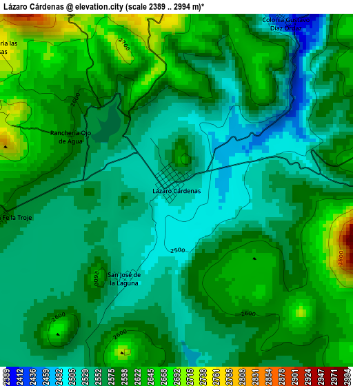
Below is the Elevation map of Lázaro Cárdenas, which displays elevation range with different colors. Scale of the first map is from 2389 to 2994 m (7838 to 9823 ft) with average elevation of 2581.5 meters (=8469 ft) [note 1]
These maps also provides idea of topography and contour of this city, they are displayed at different zoom levels. More info about maps, scale and edge coordinates you can find below images.
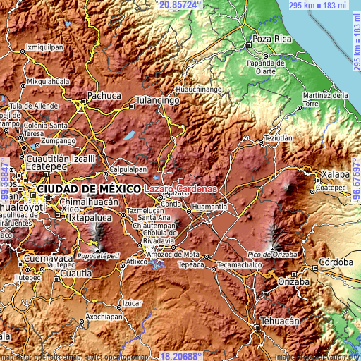
| \ | Map #1 | Topo.Map |
| Scale [m] | 2389..2994 m | × |
| Scale [ft] | 7838..9823 ft | × |
| Average | 2581.5 m = 8469 ft | × |
| Width | 9.21 km = 5.7 mi | 294.7 km = 183.1 mi |
| Height | 9.21 km = 5.7 mi | 294.7 km = 183.1 mi |
| ↑Max Latitude | 19.57891° | 20.85724° |
| Latitude at center | 19.5375° | 19.5375° |
| ↓Min Latitude | 19.49608° | 18.20688° |
| ← Min Longitude | -98.026165° | -99.38847° |
| Longitude center | -97.98222° | -97.98222° |
| →Max Longitude | -97.938275° | -96.57597° |
Nearby cities:
Cities around Lázaro Cárdenas sort by population:
• Tetla elevation 2487 m
16.5 km,  230°
230°
• Xaloztoc 2517 m
15.9 km,  204°
204°
• Santa María Texcalac 2425 m
16.8 km,  220°
220°
• Terrenate 2677 m
9.4 km,  136°
136°
• Toluca de Guadalupe 2656 m
8.1 km,  160°
160°
• Emiliano Zapata 2915 m
7.3 km,  71°
71°
• El Carmen Xalpatlahuaya 2501 m
16.2 km,  179°
179°
• Nicolás Bravo 2518 m
12.9 km,  173°
173°
• San José Villarreal 3077 m
8.9 km,  93°
93°
• Capula 2603 m
6.3 km,  268°
268°
• Guadalupe Texcalac 2454 m
14.9 km, 222°
• Calpanería Atezquilla 2825 m
13.2 km,  354°
354°
Multilingual:
 En español:
Lázaro Cárdenas elevación 2521 m.
 En France:
Lázaro Cárdenas élévation 2521 m.
 Auf Deutsch:
Lázaro Cárdenas höhe über dem Meeresspiegel ist 2521 m.

Sources and notes:
- [note 1] Map square and city borders are not equal. Map elevation data is calculated only from area inside that square.
- [src 1] Elevation data from geonames database provided with same terms of usage.
- [src 2] The elevation map of Lázaro Cárdenas is generated using elevation data from NASA's 3 arcsec (90m) resolution SRTM data.
- [src 3] Base (background) map © OpenStreetMap contributors tiles are generated by Geofabrik and OpenTopoMap.
Copyright & License:
This Lázaro Cárdenas Elevation Map is licensed under CC BY-SA. You may reuse any part from this page, if you give a proper credit by linking to this URL:
 More info on terms of use page.