Tetla elevation
Tetla (Tlaxcala, Tetla de la Solidaridad), Mexico elevation is 2487 meters and Tetla elevation in feet is 8159 ft above sea level [src 1]. Tetla is a seat of a second-order administrative division (feature code) with elevation that is 1173 meters (3848 ft) bigger than average city elevation in Mexico.
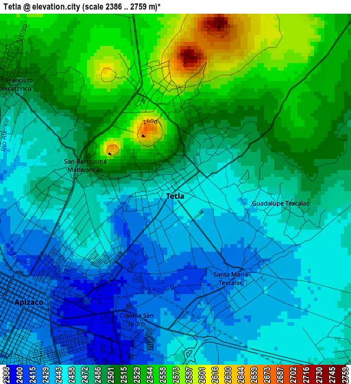
Below is the Elevation map of Tetla, which displays elevation range with different colors. Scale of the first map is from 2386 to 2759 m (7828 to 9052 ft) with average elevation of 2485.1 meters (=8153 ft) [note 1]
These maps also provides idea of topography and contour of this city, they are displayed at different zoom levels. More info about maps, scale and edge coordinates you can find below images.
| \ | Map #1 | Map #2 | Topo.Map |
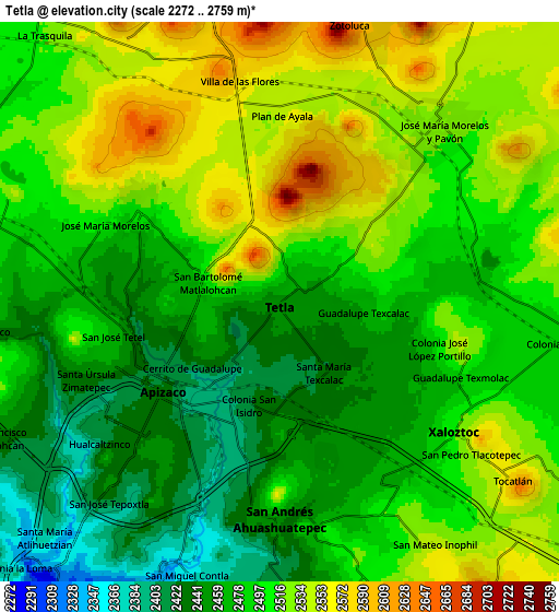
| Scale [m] | 2386..2759 m | 2272..2759 m | × |
| Scale [ft] | 7828..9052 ft | 7454..9052 ft | × |
| Average | 2485.1 m = 8153 ft | 2495.4 m = 8187 ft | × |
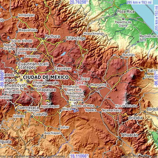
| Width | 9.22 km = 5.7 mi | 18.43 km = 11.5 mi | 294.9 km = 183.2 mi |
| Height | 9.22 km = 5.7 mi | 18.43 km = 11.5 mi | 294.9 km = 183.2 mi |
| ↑Max Latitude | 19.483474° | 19.524898° | 20.76258° |
| Latitude at center | 19.44204° | 19.44204° | 19.44204° |
| ↓Min Latitude | 19.400595° | 19.35914° | 18.11066° |
| ← Min Longitude | -98.147195° | -98.191141° | -99.5095° |
| Longitude center | -98.10325° | -98.10325° | -98.10325° |
| →Max Longitude | -98.059305° | -98.015359° | -96.697° |
Nearby cities:
Cities around Tetla sort by population:
• Apizaco elevation 2424 m
5.3 km,  232°
232°
• Xaloztoc 2517 m
7.1 km,  122°
122°
• San Andrés Ahuashuatepec 2459 m
7.1 km,  182°
182°
• Zimatepec 2448 m
6.8 km,  250°
250°
• Santa María Texcalac 2425 m
2.7 km,  140°
140°
• San Luis Apizaquito 2413 m
2.4 km,  217°
217°
• San José Tetel 2487 m
6 km,  260°
260°
• Atexcatzingo 2509 m
5.5 km,  302°
302°
• Colonia Venustiano Carranza 2474 m
6.6 km,  134°
134°
• Colonia San Isidro 2420 m
3.5 km,  196°
196°
• Guadalupe Texcalac 2454 m
2.7 km,  98°
98°
• José María Morelos 2511 m
6.4 km,  294°
294°
Multilingual:
 En español:
Tetla elevación 2487 m.
 En France:
Tetla élévation 2487 m.


Sources and notes:
- [note 1] Map square and city borders are not equal. Map elevation data is calculated only from area inside that square.
- [src 1] Elevation data from geonames database provided with same terms of usage.
- [src 2] The elevation map of Tetla is generated using elevation data from NASA's 3 arcsec (90m) resolution SRTM data.
- [src 3] Base (background) map © OpenStreetMap contributors tiles are generated by Geofabrik and OpenTopoMap.
Copyright & License:
This Tetla Elevation Map is licensed under CC BY-SA. You may reuse any part from this page, if you give a proper credit by linking to this URL:
 More info on terms of use page.