San Andrés Ahuashuatepec elevation
San Andrés Ahuashuatepec (Tlaxcala, Tzompantepec), Mexico elevation is 2459 meters and San Andrés Ahuashuatepec elevation in feet is 8068 ft above sea level [src 1]. San Andrés Ahuashuatepec is a populated place (feature code) with elevation that is 1145 meters (3757 ft) bigger than average city elevation in Mexico.
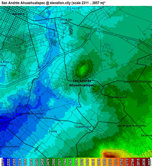
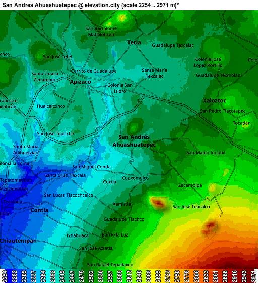
Below is the Elevation map of San Andrés Ahuashuatepec, which displays elevation range with different colors. Scale of the first map is from 2311 to 2857 m (7582 to 9373 ft) with average elevation of 2438 meters (=7999 ft) [note 1]
These maps also provides idea of topography and contour of this city, they are displayed at different zoom levels. More info about maps, scale and edge coordinates you can find below images.
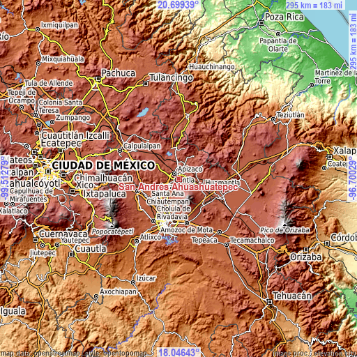
| \ | Map #1 | Map #2 | Topo.Map |
| Scale [m] | 2311..2857 m | 2254..2971 m | × |
| Scale [ft] | 7582..9373 ft | 7395..9747 ft | × |
| Average | 2438 m = 7999 ft | 2482.9 m = 8146 ft | × |
| Width | 9.22 km = 5.7 mi | 18.44 km = 11.5 mi | 295 km = 183.3 mi |
| Height | 9.22 km = 5.7 mi | 18.44 km = 11.5 mi | 295 km = 183.3 mi |
| ↑Max Latitude | 19.41976° | 19.4612° | 20.69939° |
| Latitude at center | 19.37831° | 19.37831° | 19.37831° |
| ↓Min Latitude | 19.336849° | 19.295377° | 18.04643° |
| ← Min Longitude | -98.150485° | -98.194431° | -99.51279° |
| Longitude center | -98.10654° | -98.10654° | -98.10654° |
| →Max Longitude | -98.062595° | -98.018649° | -96.70029° |
Nearby cities:
Cities around San Andrés Ahuashuatepec sort by population:
• Apizaco elevation 2424 m
5.5 km,  315°
315°
• Santa Anita Huiloac 2429 m
4 km,  286°
286°
• Santa María Texcalac 2425 m
5.4 km,  22°
22°
• San Luis Apizaquito 2413 m
5.3 km,  348°
348°
• San Miguel Contla 2360 m
3.3 km,  234°
234°
• Santa Cruz Tlaxcala 2325 m
5.3 km,  240°
240°
• Cuaxomulco 2440 m
3 km,  160°
160°
• Colonia San Isidro 2420 m
3.8 km, 349°
• Tzompantepec 2488 m
1.7 km,  98°
98°
• San Juan Quetzalcoapan 2514 m
3.7 km,  88°
88°
• Jesús Huitznahuac 2404 m
4.6 km,  209°
209°
• San Lorenzo Xaltelulco 2474 m
4.2 km,  179°
179°
Multilingual:
 En español:
San Andrés Ahuashuatepec elevación 2459 m.
 En France:
San Andrés Ahuashuatepec élévation 2459 m.
 Auf Deutsch:
San Andrés Ahuashuatepec höhe über dem Meeresspiegel ist 2459 m.
 На русском:
San Andrés Ahuashuatepec высота над уровнем моря 2459 м
Sources and notes:
- [note 1] Map square and city borders are not equal. Map elevation data is calculated only from area inside that square.
- [src 1] Elevation data from geonames database provided with same terms of usage.
- [src 2] The elevation map of San Andrés Ahuashuatepec is generated using elevation data from NASA's 3 arcsec (90m) resolution SRTM data.
- [src 3] Base (background) map © OpenStreetMap contributors tiles are generated by Geofabrik and OpenTopoMap.
Copyright & License:
This San Andrés Ahuashuatepec Elevation Map is licensed under CC BY-SA. You may reuse any part from this page, if you give a proper credit by linking to this URL:
 More info on terms of use page.