San José Xicohténcatl elevation
San José Xicohténcatl (Tlaxcala, Huamantla), Mexico elevation is 2455 meters and San José Xicohténcatl elevation in feet is 8054 ft above sea level [src 1]. San José Xicohténcatl is a populated place (feature code) with elevation that is 1141 meters (3743 ft) bigger than average city elevation in Mexico.
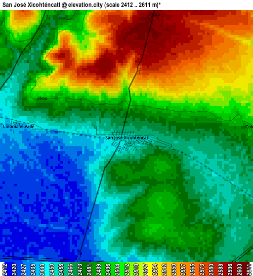
Below is the Elevation map of San José Xicohténcatl, which displays elevation range with different colors. Scale of the first map is from 2412 to 2611 m (7913 to 8566 ft) with average elevation of 2487.8 meters (=8162 ft) [note 1]
These maps also provides idea of topography and contour of this city, they are displayed at different zoom levels. More info about maps, scale and edge coordinates you can find below images.
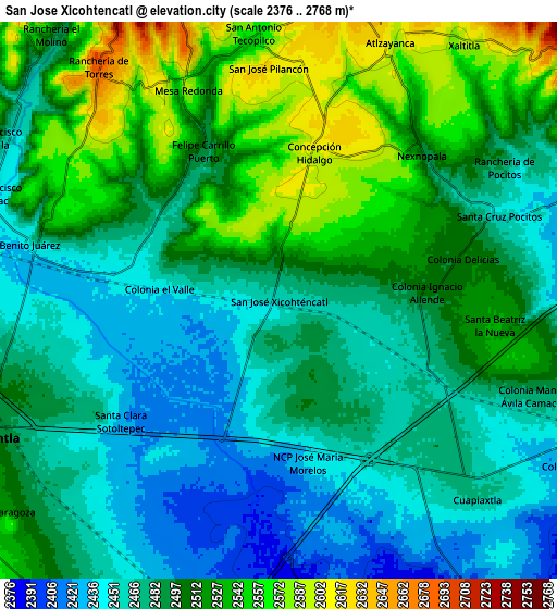
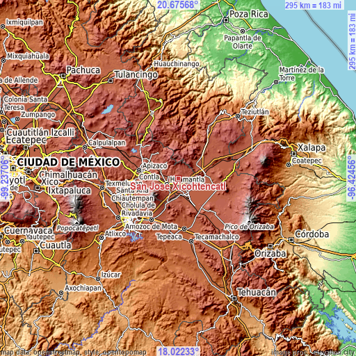
| \ | Map #1 | Map #2 | Topo.Map |
| Scale [m] | 2412..2611 m | 2376..2768 m | × |
| Scale [ft] | 7913..8566 ft | 7795..9081 ft | × |
| Average | 2487.8 m = 8162 ft | 2494.3 m = 8183 ft | × |
| Width | 9.22 km = 5.7 mi | 18.44 km = 11.5 mi | 295 km = 183.3 mi |
| Height | 9.22 km = 5.7 mi | 18.44 km = 11.5 mi | 295 km = 183.3 mi |
| ↑Max Latitude | 19.395857° | 19.437303° | 20.67568° |
| Latitude at center | 19.3544° | 19.3544° | 19.3544° |
| ↓Min Latitude | 19.312933° | 19.271455° | 18.02233° |
| ← Min Longitude | -97.874755° | -97.918701° | -99.23706° |
| Longitude center | -97.83081° | -97.83081° | -97.83081° |
| →Max Longitude | -97.786865° | -97.742919° | -96.42456° |
Nearby cities:
Cities around San José Xicohténcatl sort by population:
• Huamantla elevation 2519 m
10.9 km,  245°
245°
• Cuapiaxtla 2471 m
9.2 km,  135°
135°
• Ignacio Zaragoza 2531 m
11.7 km,  233°
233°
• Benito Juárez 2447 m
8.5 km,  284°
284°
• Máximo Serdán 2402 m
10.2 km,  178°
178°
• Atlzayanca 2603 m
9.3 km,  23°
23°
• Altzayanca 2603 m
9.3 km, 23°
• Concepción Hidalgo 2602 m
5 km,  13°
13°
• Colonia Ignacio Allende 2502 m
4.9 km,  87°
87°
• Santa Cruz Pocitos 2456 m
7.8 km,  69°
69°
• Ranchería de Pocitos 2472 m
8.7 km,  59°
59°
• Felipe Carrillo Puerto 2496 m
5.6 km,  332°
332°
Multilingual:
 En español:
San José Xicohténcatl elevación 2455 m.
 En France:
San José Xicohténcatl élévation 2455 m.
 Auf Deutsch:
San José Xicohténcatl höhe über dem Meeresspiegel ist 2455 m.
 На русском:
San José Xicohténcatl высота над уровнем моря 2455 м
Sources and notes:
- [note 1] Map square and city borders are not equal. Map elevation data is calculated only from area inside that square.
- [src 1] Elevation data from geonames database provided with same terms of usage.
- [src 2] The elevation map of San José Xicohténcatl is generated using elevation data from NASA's 3 arcsec (90m) resolution SRTM data.
- [src 3] Base (background) map © OpenStreetMap contributors tiles are generated by Geofabrik and OpenTopoMap.
Copyright & License:
This San José Xicohténcatl Elevation Map is licensed under CC BY-SA. You may reuse any part from this page, if you give a proper credit by linking to this URL:
 More info on terms of use page.