Ixtacamaxtitlán elevation
Ixtacamaxtitlán (Puebla), Mexico elevation is 2117 meters and Ixtacamaxtitlán elevation in feet is 6946 ft above sea level [src 1]. Ixtacamaxtitlán is a seat of a second-order administrative division (feature code) with elevation that is 803 meters (2635 ft) bigger than average city elevation in Mexico.
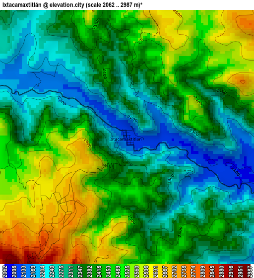
Below is the Elevation map of Ixtacamaxtitlán, which displays elevation range with different colors. Scale of the first map is from 2062 to 2987 m (6765 to 9800 ft) with average elevation of 2404 meters (=7887 ft) [note 1]
These maps also provides idea of topography and contour of this city, they are displayed at different zoom levels. More info about maps, scale and edge coordinates you can find below images.
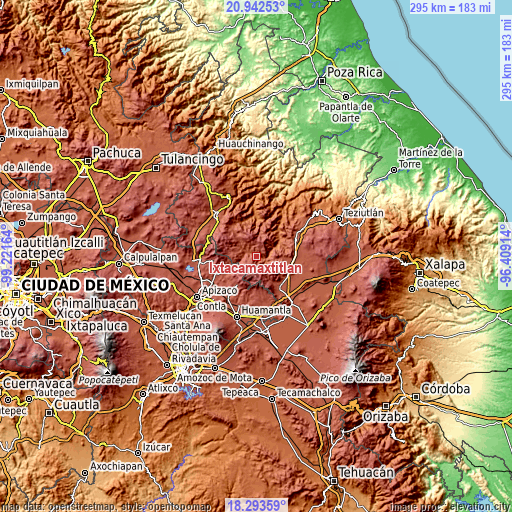
| \ | Map #1 | Topo.Map |
| Scale [m] | 2062..2987 m | × |
| Scale [ft] | 6765..9800 ft | × |
| Average | 2404 m = 7887 ft | × |
| Width | 9.2 km = 5.7 mi | 294.5 km = 183 mi |
| Height | 9.2 km = 5.7 mi | 294.6 km = 183.1 mi |
| ↑Max Latitude | 19.664908° | 20.94253° |
| Latitude at center | 19.62352° | 19.62352° |
| ↓Min Latitude | 19.582122° | 18.29359° |
| ← Min Longitude | -97.859335° | -99.22164° |
| Longitude center | -97.81539° | -97.81539° |
| →Max Longitude | -97.771445° | -96.40914° |
Nearby cities:
Cities around Ixtacamaxtitlán sort by population:
• Emiliano Zapata elevation 2915 m
12.8 km,  235°
235°
• Temextla 2450 m
15.6 km,  95°
95°
• Guadalupe Victoria 2436 m
17.8 km,  113°
113°
• San José Villarreal 3077 m
13.3 km,  220°
220°
• La Unión Ejido Mexcaltepec 2510 m
11.1 km, 98°
• Ocotepec 2465 m
18.8 km, 113°
• Tlamanca 1999 m
13.7 km,  65°
65°
• El Mirador 2789 m
8.7 km,  148°
148°
• La Cañada 2578 m
16.3 km, 148°
• Calpanería Atezquilla 2825 m
19.2 km,  280°
280°
• San Andrés Yahuitlalpan 2034 m
10.8 km,  59°
59°
• Zautla 1990 m
18.2 km, 56°
Multilingual:
 En español:
San Francisco elevación 2117 m.
 En France:
Ixtacamaxtitlán élévation 2117 m.
 Auf Deutsch:
Ixtacamaxtitlán höhe über dem Meeresspiegel ist 2117 m.

Sources and notes:
- [note 1] Map square and city borders are not equal. Map elevation data is calculated only from area inside that square.
- [src 1] Elevation data from geonames database provided with same terms of usage.
- [src 2] The elevation map of Ixtacamaxtitlán is generated using elevation data from NASA's 3 arcsec (90m) resolution SRTM data.
- [src 3] Base (background) map © OpenStreetMap contributors tiles are generated by Geofabrik and OpenTopoMap.
Copyright & License:
This Ixtacamaxtitlán Elevation Map is licensed under CC BY-SA. You may reuse any part from this page, if you give a proper credit by linking to this URL:
 More info on terms of use page.