San Andrés Yahuitlalpan elevation
San Andrés Yahuitlalpan (Puebla, Zautla), Mexico elevation is 2034 meters and San Andrés Yahuitlalpan elevation in feet is 6673 ft above sea level [src 1]. San Andrés Yahuitlalpan is a populated place (feature code) with elevation that is 720 meters (2362 ft) bigger than average city elevation in Mexico.
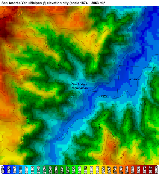
Below is the Elevation map of San Andrés Yahuitlalpan, which displays elevation range with different colors. Scale of the first map is from 1874 to 3063 m (6148 to 10049 ft) with average elevation of 2343.2 meters (=7688 ft) [note 1]
These maps also provides idea of topography and contour of this city, they are displayed at different zoom levels. More info about maps, scale and edge coordinates you can find below images.
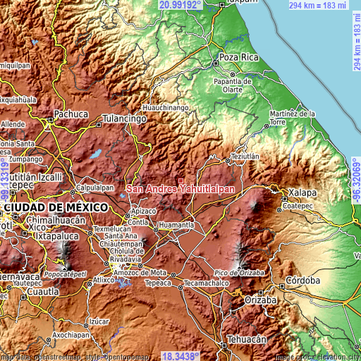
| \ | Map #1 | Topo.Map |
| Scale [m] | 1874..3063 m | × |
| Scale [ft] | 6148..10049 ft | × |
| Average | 2343.2 m = 7688 ft | × |
| Width | 9.2 km = 5.7 mi | 294.4 km = 182.9 mi |
| Height | 9.2 km = 5.7 mi | 294.5 km = 183 mi |
| ↑Max Latitude | 19.714705° | 20.99192° |
| Latitude at center | 19.67333° | 19.67333° |
| ↓Min Latitude | 19.631945° | 18.3438° |
| ← Min Longitude | -97.770885° | -99.13319° |
| Longitude center | -97.72694° | -97.72694° |
| →Max Longitude | -97.682995° | -96.32069° |
Nearby cities:
Cities around San Andrés Yahuitlalpan sort by population:
• San Miguel Tenextatiloyan elevation 2429 m
14.1 km,  73°
73°
• La Libertad 2388 m
15.5 km,  53°
53°
• Temextla 2450 m
9.5 km,  138°
138°
• Cuyoaco 2435 m
13.7 km,  125°
125°
• Emilio Carranza (Santa Cruz) 2101 m
8.9 km,  60°
60°
• Guadalupe Victoria 2436 m
14.4 km,  150°
150°
• La Unión Ejido Mexcaltepec 2510 m
7.5 km,  166°
166°
• Ocotepec 2465 m
15.4 km, 148°
• Tlamanca 1999 m
3.2 km,  87°
87°
• El Mirador 2789 m
13.8 km,  200°
200°
• Zautla 1990 m
7.4 km, 51°
• Ixtacamaxtitlán 2117 m
10.8 km,  239°
239°
Multilingual:
 En español:
San Andrés Yahuitlalpan elevación 2034 m.
 En France:
San Andrés Yahuitlalpan élévation 2034 m.
 Auf Deutsch:
San Andrés Yahuitlalpan höhe über dem Meeresspiegel ist 2034 m.
 На русском:
San Andrés Yahuitlalpan высота над уровнем моря 2034 м
Sources and notes:
- [note 1] Map square and city borders are not equal. Map elevation data is calculated only from area inside that square.
- [src 1] Elevation data from geonames database provided with same terms of usage.
- [src 2] The elevation map of San Andrés Yahuitlalpan is generated using elevation data from NASA's 3 arcsec (90m) resolution SRTM data.
- [src 3] Base (background) map © OpenStreetMap contributors tiles are generated by Geofabrik and OpenTopoMap.
Copyright & License:
This San Andrés Yahuitlalpan Elevation Map is licensed under CC BY-SA. You may reuse any part from this page, if you give a proper credit by linking to this URL:
 More info on terms of use page.