San Miguel Tenextatiloyan elevation
San Miguel Tenextatiloyan (Puebla, Zautla), Mexico elevation is 2429 meters and San Miguel Tenextatiloyan elevation in feet is 7969 ft above sea level [src 1]. San Miguel Tenextatiloyan is a populated place (feature code) with elevation that is 1115 meters (3658 ft) bigger than average city elevation in Mexico.
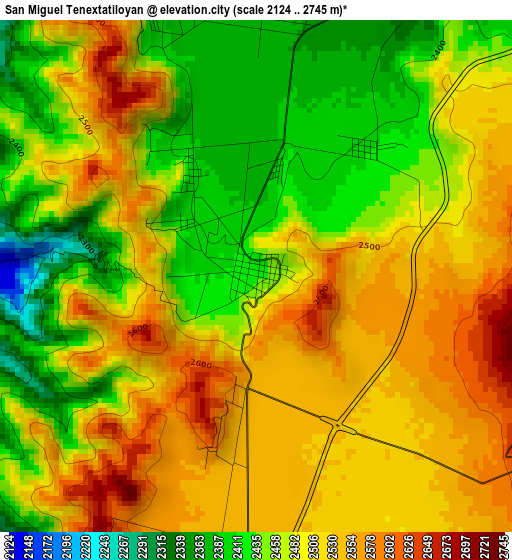
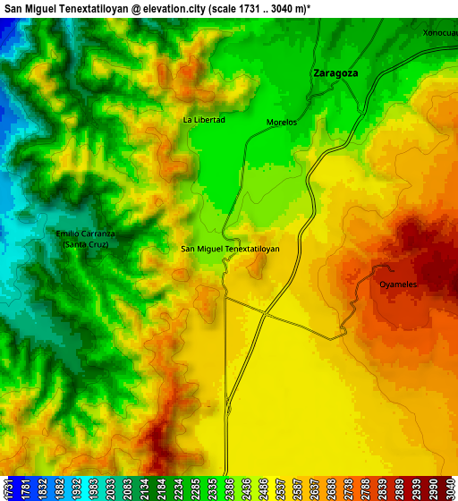
Below is the Elevation map of San Miguel Tenextatiloyan, which displays elevation range with different colors. Scale of the first map is from 2124 to 2745 m (6969 to 9006 ft) with average elevation of 2487.3 meters (=8160 ft) [note 1]
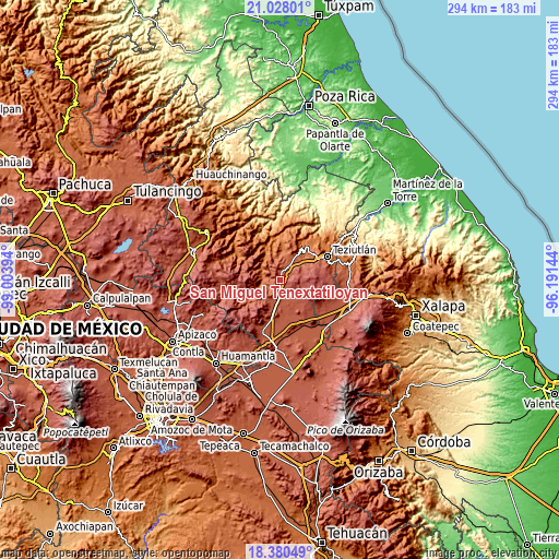
These maps also provides idea of topography and contour of this city, they are displayed at different zoom levels. More info about maps, scale and edge coordinates you can find below images.
| \ | Map #1 | Map #2 | Topo.Map |
| Scale [m] | 2124..2745 m | 1731..3040 m | × |
| Scale [ft] | 6969..9006 ft | 5679..9974 ft | × |
| Average | 2487.3 m = 8160 ft | 2448.4 m = 8033 ft | × |
| Width | 9.2 km = 5.7 mi | 18.4 km = 11.4 mi | 294.4 km = 182.9 mi |
| Height | 9.2 km = 5.7 mi | 18.4 km = 11.4 mi | 294.4 km = 182.9 mi |
| ↑Max Latitude | 19.751095° | 19.79245° | 21.02801° |
| Latitude at center | 19.70973° | 19.70973° | 19.70973° |
| ↓Min Latitude | 19.668354° | 19.626967° | 18.38049° |
| ← Min Longitude | -97.641635° | -97.685581° | -99.00394° |
| Longitude center | -97.59769° | -97.59769° | -97.59769° |
| →Max Longitude | -97.553745° | -97.509799° | -96.19144° |
Nearby cities:
Cities around San Miguel Tenextatiloyan sort by population:
• Zaragoza elevation 2311 m
8.1 km,  33°
33°
• La Libertad 2388 m
5.2 km,  348°
348°
• Oyameles de Hidalgo 2848 m
6.8 km,  101°
101°
• Ocotlán de Betancourt 2227 m
11.7 km, 33°
• Xonocuautla 2230 m
12.2 km,  44°
44°
• Emilio Carranza (Santa Cruz) 2101 m
5.8 km,  273°
273°
• El Molino 2197 m
11.7 km,  8°
8°
• Morelos 2336 m
5.4 km,  22°
22°
• Tlamanca 1999 m
11 km,  249°
249°
• Acuaco 2296 m
6.8 km, 30°
• Texocoyohuac 2321 m
7.6 km, 5°
• Zautla 1990 m
7.7 km, 274°
Multilingual:
 En español:
San Miguel Tenextatiloyan elevación 2429 m.
 En France:
San Miguel Tenextatiloyan élévation 2429 m.
 Auf Deutsch:
San Miguel Tenextatiloyan höhe über dem Meeresspiegel ist 2429 m.
 На русском:
San Miguel Tenextatiloyan высота над уровнем моря 2429 м
Sources and notes:
- [note 1] Map square and city borders are not equal. Map elevation data is calculated only from area inside that square.
- [src 1] Elevation data from geonames database provided with same terms of usage.
- [src 2] The elevation map of San Miguel Tenextatiloyan is generated using elevation data from NASA's 3 arcsec (90m) resolution SRTM data.
- [src 3] Base (background) map © OpenStreetMap contributors tiles are generated by Geofabrik and OpenTopoMap.
Copyright & License:
This San Miguel Tenextatiloyan Elevation Map is licensed under CC BY-SA. You may reuse any part from this page, if you give a proper credit by linking to this URL:
 More info on terms of use page.