Xonocuautla elevation
Xonocuautla (Puebla, Tlatlauquitepec), Mexico elevation is 2230 meters and Xonocuautla elevation in feet is 7316 ft above sea level [src 1]. Xonocuautla is a populated place (feature code) with elevation that is 916 meters (3005 ft) bigger than average city elevation in Mexico.
Below is the Elevation map of Xonocuautla, which displays elevation range with different colors. Scale of the first map is from 1898 to 2803 m (6227 to 9196 ft) with average elevation of 2282.4 meters (=7488 ft) [note 1]
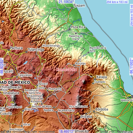
These maps also provides idea of topography and contour of this city, they are displayed at different zoom levels. More info about maps, scale and edge coordinates you can find below images.
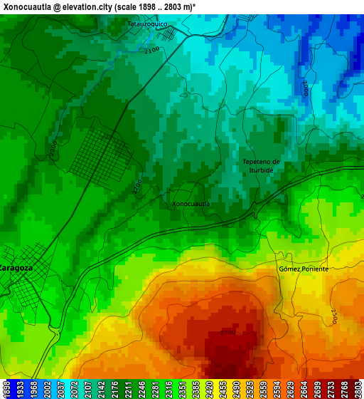
| \ | Map #1 | Topo.Map |
| Scale [m] | 1898..2803 m | × |
| Scale [ft] | 6227..9196 ft | × |
| Average | 2282.4 m = 7488 ft | × |
| Width | 9.2 km = 5.7 mi | 294.2 km = 182.8 mi |
| Height | 9.2 km = 5.7 mi | 294.3 km = 182.9 mi |
| ↑Max Latitude | 19.830075° | 21.10634° |
| Latitude at center | 19.78873° | 19.78873° |
| ↓Min Latitude | 19.747374° | 18.46013° |
| ← Min Longitude | -97.560215° | -98.92252° |
| Longitude center | -97.51627° | -97.51627° |
| →Max Longitude | -97.472325° | -96.11002° |
Nearby cities:
Cities around Xonocuautla sort by population:
• Zaragoza elevation 2311 m
4.5 km,  244°
244°
• Tlatlauquitepec 1929 m
6.8 km,  16°
16°
• Ocotlán de Betancourt 2227 m
2.3 km,  294°
294°
• El Mirador 2064 m
4 km,  359°
359°
• Tatauzoquico 2096 m
4.5 km,  345°
345°
• Tezhuatepec 2082 m
6.2 km,  65°
65°
• Gómez Poniente 2408 m
3.6 km,  120°
120°
• Tepeteno de Iturbide 2167 m
2.1 km, 68°
• Pezmatlán 1905 m
7.2 km,  26°
26°
• Tanhuixco 1995 m
6.2 km,  55°
55°
• Nexticapan 2202 m
5.8 km,  317°
317°
• Acuaco 2296 m
5.8 km, 239°
Multilingual:
 En español:
Xonocuautla elevación 2230 m.
 En France:
Xonocuautla élévation 2230 m.
 Auf Deutsch:
Xonocuautla höhe über dem Meeresspiegel ist 2230 m.

Sources and notes:
- [note 1] Map square and city borders are not equal. Map elevation data is calculated only from area inside that square.
- [src 1] Elevation data from geonames database provided with same terms of usage.
- [src 2] The elevation map of Xonocuautla is generated using elevation data from NASA's 3 arcsec (90m) resolution SRTM data.
- [src 3] Base (background) map © OpenStreetMap contributors tiles are generated by Geofabrik and OpenTopoMap.
Copyright & License:
This Xonocuautla Elevation Map is licensed under CC BY-SA. You may reuse any part from this page, if you give a proper credit by linking to this URL:
 More info on terms of use page.