Chitejé de Garabato elevation
Chitejé de Garabato (Michoacán), Mexico elevation is 2456 meters and Chitejé de Garabato elevation in feet is 8058 ft above sea level [src 1]. Chitejé de Garabato is a populated place (feature code) with elevation that is 1142 meters (3747 ft) bigger than average city elevation in Mexico.
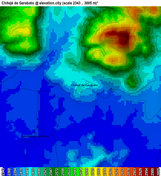
Below is the Elevation map of Chitejé de Garabato, which displays elevation range with different colors. Scale of the first map is from 2343 to 3005 m (7687 to 9859 ft) with average elevation of 2467.4 meters (=8095 ft) [note 1]
These maps also provides idea of topography and contour of this city, they are displayed at different zoom levels. More info about maps, scale and edge coordinates you can find below images.
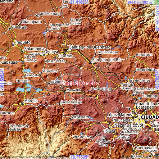
| \ | Map #1 | Topo.Map |
| Scale [m] | 2343..3005 m | × |
| Scale [ft] | 7687..9859 ft | × |
| Average | 2467.4 m = 8095 ft | × |
| Width | 9.18 km = 5.7 mi | 293.6 km = 182.4 mi |
| Height | 9.18 km = 5.7 mi | 293.7 km = 182.5 mi |
| ↑Max Latitude | 20.142373° | 21.41603° |
| Latitude at center | 20.10111° | 20.10111° |
| ↓Min Latitude | 20.059836° | 18.77505° |
| ← Min Longitude | -100.232935° | -101.59524° |
| Longitude center | -100.18899° | -100.18899° |
| →Max Longitude | -100.145045° | -98.78274° |
Nearby cities:
Cities around Chitejé de Garabato sort by population:
• Amealco elevation 2638 m
10.7 km,  25°
25°
• Contepec 2492 m
16.5 km,  170°
170°
• Tepuxtepec 2369 m
12.8 km,  197°
197°
• San José Itho 2694 m
9.6 km,  42°
42°
• San Antonio Solís 2374 m
15.6 km,  136°
136°
• Atotonilco 2322 m
18.1 km,  191°
191°
• La Soledad 2747 m
7.6 km,  358°
358°
• Epitacio Huerta 2452 m
11.5 km,  289°
289°
• Santiago Mexquititlán Barrio 4to. 2396 m
13.3 km,  108°
108°
• Dolores 2434 m
14.6 km,  252°
252°
• San Nicolás de la Torre 2428 m
9.5 km, 105°
• San Antonio Molinos 2366 m
3.9 km,  223°
223°
Multilingual:
 En español:
Chitejé de Garabato, Garabato elevación 2456 m.
 En France:
Chitejé de Garabato élévation 2456 m.
 Auf Deutsch:
Chitejé de Garabato höhe über dem Meeresspiegel ist 2456 m.
 На русском:
Chitejé de Garabato высота над уровнем моря 2456 м
Sources and notes:
- [note 1] Map square and city borders are not equal. Map elevation data is calculated only from area inside that square.
- [src 1] Elevation data from geonames database provided with same terms of usage.
- [src 2] The elevation map of Chitejé de Garabato is generated using elevation data from NASA's 3 arcsec (90m) resolution SRTM data.
- [src 3] Base (background) map © OpenStreetMap contributors tiles are generated by Geofabrik and OpenTopoMap.
Copyright & License:
This Chitejé de Garabato Elevation Map is licensed under CC BY-SA. You may reuse any part from this page, if you give a proper credit by linking to this URL:
 More info on terms of use page.