Amealco elevation
Amealco (Querétaro, Amealco de Bonfil), Mexico elevation is 2638 meters and Amealco elevation in feet is 8655 ft above sea level [src 1]. Amealco is a seat of a second-order administrative division (feature code) with elevation that is 1324 meters (4344 ft) bigger than average city elevation in Mexico.
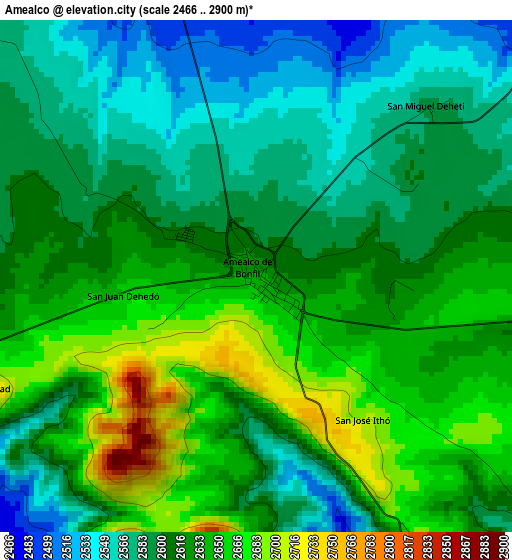
Below is the Elevation map of Amealco, which displays elevation range with different colors. Scale of the first map is from 2466 to 2900 m (8091 to 9514 ft) with average elevation of 2613.2 meters (=8573 ft) [note 1]
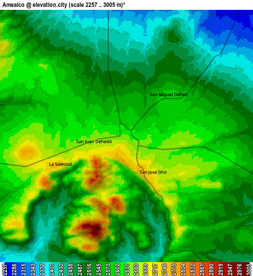
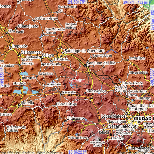
These maps also provides idea of topography and contour of this city, they are displayed at different zoom levels. More info about maps, scale and edge coordinates you can find below images.
| \ | Map #1 | Map #2 | Topo.Map |
| Scale [m] | 2466..2900 m | 2257..3005 m | × |
| Scale [ft] | 8091..9514 ft | 7405..9859 ft | × |
| Average | 2613.2 m = 8573 ft | 2548.8 m = 8362 ft | × |
| Width | 9.17 km = 5.7 mi | 18.34 km = 11.4 mi | 293.5 km = 182.4 mi |
| Height | 9.17 km = 5.7 mi | 18.34 km = 11.4 mi | 293.5 km = 182.4 mi |
| ↑Max Latitude | 20.22882° | 20.270049° | 21.50175° |
| Latitude at center | 20.18758° | 20.18758° | 20.18758° |
| ↓Min Latitude | 20.146329° | 20.105067° | 18.86223° |
| ← Min Longitude | -100.188795° | -100.232741° | -101.5511° |
| Longitude center | -100.14485° | -100.14485° | -100.14485° |
| →Max Longitude | -100.100905° | -100.056959° | -98.7386° |
Nearby cities:
Cities around Amealco sort by population:
• San Ildefonso Tultepec elevation 2391 m
20 km,  104°
104°
• Dolores Cuadrilla de Enmedio 2106 m
19.6 km,  20°
20°
• Chitejé de Garabato 2456 m
10.7 km,  205°
205°
• San José Itho 2694 m
3.1 km,  142°
142°
• Laguna de Vaquerías 2201 m
18.5 km,  3°
3°
• La Soledad 2747 m
5.2 km,  247°
247°
• Epitacio Huerta 2452 m
16.6 km, 249°
• Santiago Mexquititlán Barrio 4to. 2396 m
16 km,  150°
150°
• Mesillas 2397 m
16 km,  110°
110°
• San Pedro Denxhi Centro 2238 m
19.8 km,  69°
69°
• San Nicolás de la Torre 2428 m
13 km,  159°
159°
• San Antonio Molinos 2366 m
14.5 km, 210°
Multilingual:
 En español:
Amealco, Amealco de Bonfil elevación 2638 m.
 En France:
Amealco élévation 2638 m.
 Auf Deutsch:
Amealco höhe über dem Meeresspiegel ist 2638 m.

Sources and notes:
- [note 1] Map square and city borders are not equal. Map elevation data is calculated only from area inside that square.
- [src 1] Elevation data from geonames database provided with same terms of usage.
- [src 2] The elevation map of Amealco is generated using elevation data from NASA's 3 arcsec (90m) resolution SRTM data.
- [src 3] Base (background) map © OpenStreetMap contributors tiles are generated by Geofabrik and OpenTopoMap.
Copyright & License:
This Amealco Elevation Map is licensed under CC BY-SA. You may reuse any part from this page, if you give a proper credit by linking to this URL:
 More info on terms of use page.