Epitacio Huerta elevation
Epitacio Huerta (State of Mexico), Mexico elevation is 2452 meters and Epitacio Huerta elevation in feet is 8045 ft above sea level [src 1]. Epitacio Huerta is a populated place (feature code) with elevation that is 1138 meters (3734 ft) bigger than average city elevation in Mexico.
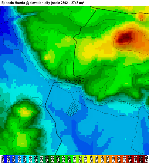
Below is the Elevation map of Epitacio Huerta, which displays elevation range with different colors. Scale of the first map is from 2302 to 2747 m (7552 to 9012 ft) with average elevation of 2443.4 meters (=8016 ft) [note 1]
These maps also provides idea of topography and contour of this city, they are displayed at different zoom levels. More info about maps, scale and edge coordinates you can find below images.
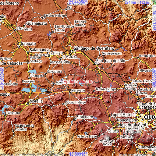
| \ | Map #1 | Topo.Map |
| Scale [m] | 2302..2747 m | × |
| Scale [ft] | 7552..9012 ft | × |
| Average | 2443.4 m = 8016 ft | × |
| Width | 9.18 km = 5.7 mi | 293.6 km = 182.4 mi |
| Height | 9.18 km = 5.7 mi | 293.6 km = 182.4 mi |
| ↑Max Latitude | 20.176184° | 21.44956° |
| Latitude at center | 20.13493° | 20.13493° |
| ↓Min Latitude | 20.093665° | 18.80915° |
| ← Min Longitude | -100.337155° | -101.69946° |
| Longitude center | -100.29321° | -100.29321° |
| →Max Longitude | -100.249265° | -98.88696° |
Nearby cities:
Cities around Epitacio Huerta sort by population:
• Jerécuaro elevation 1967 m
22.6 km,  275°
275°
• Amealco 2638 m
16.6 km,  69°
69°
• Coroneo 2277 m
10.5 km,  313°
313°
• Puroagua 2041 m
17.8 km,  249°
249°
• Tepuxtepec 2369 m
17.5 km,  156°
156°
• Chitejé de Garabato 2456 m
11.5 km,  109°
109°
• San José Itho 2694 m
17.7 km,  78°
78°
• La Soledad 2747 m
11.3 km, 70°
• San Pedro 2399 m
20.7 km,  2°
2°
• Dolores 2434 m
8.8 km,  200°
200°
• San Nicolás de la Torre 2428 m
21 km, 107°
• San Antonio Molinos 2366 m
10.5 km,  129°
129°
Multilingual:
 En español:
Epitacio Huerta elevación 2452 m.
 En France:
Epitacio Huerta élévation 2452 m.
 Auf Deutsch:
Epitacio Huerta höhe über dem Meeresspiegel ist 2452 m.

Sources and notes:
- [note 1] Map square and city borders are not equal. Map elevation data is calculated only from area inside that square.
- [src 1] Elevation data from geonames database provided with same terms of usage.
- [src 2] The elevation map of Epitacio Huerta is generated using elevation data from NASA's 3 arcsec (90m) resolution SRTM data.
- [src 3] Base (background) map © OpenStreetMap contributors tiles are generated by Geofabrik and OpenTopoMap.
Copyright & License:
This Epitacio Huerta Elevation Map is licensed under CC BY-SA. You may reuse any part from this page, if you give a proper credit by linking to this URL:
 More info on terms of use page.