Puroagua elevation
Puroagua (Guanajuato, Jerécuaro), Mexico elevation is 2041 meters and Puroagua elevation in feet is 6696 ft above sea level [src 1]. Puroagua is a populated place (feature code) with elevation that is 727 meters (2385 ft) bigger than average city elevation in Mexico.
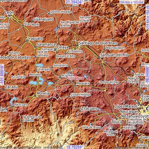
Below is the Elevation map of Puroagua, which displays elevation range with different colors. Scale of the first map is from 1889 to 2852 m (6198 to 9357 ft) with average elevation of 2126.9 meters (=6978 ft) [note 1]
These maps also provides idea of topography and contour of this city, they are displayed at different zoom levels. More info about maps, scale and edge coordinates you can find below images.

| \ | Map #1 | Topo.Map |
| Scale [m] | 1889..2852 m | × |
| Scale [ft] | 6198..9357 ft | × |
| Average | 2126.9 m = 6978 ft | × |
| Width | 9.18 km = 5.7 mi | 293.7 km = 182.5 mi |
| Height | 9.18 km = 5.7 mi | 293.7 km = 182.5 mi |
| ↑Max Latitude | 20.120399° | 21.39424° |
| Latitude at center | 20.07913° | 20.07913° |
| ↓Min Latitude | 20.03785° | 18.75289° |
| ← Min Longitude | -100.496855° | -101.85916° |
| Longitude center | -100.45291° | -100.45291° |
| →Max Longitude | -100.408965° | -99.04666° |
Nearby cities:
Cities around Puroagua sort by population:
• Maravatío de Ocampo elevation 2019 m
20.9 km,  177°
177°
• Jerécuaro 1967 m
10.2 km,  325°
325°
• Tarandacuao 1945 m
11.1 km,  218°
218°
• Tungareo 2029 m
21 km,  154°
154°
• Coroneo 2277 m
16.2 km,  34°
34°
• Uripitio 2021 m
16.6 km,  212°
212°
• Estanzuela de Romero 2022 m
12.9 km,  335°
335°
• Tziritzícuaro 1973 m
13.7 km, 182°
• El Fresno 2167 m
22 km,  349°
349°
• Epitacio Huerta 2452 m
17.8 km,  69°
69°
• Dolores 2434 m
13.8 km,  98°
98°
• Ojo de Agua de Mendoza 1988 m
15.5 km,  308°
308°
Multilingual:
 En español:
Puroagua elevación 2041 m.
 En France:
Puroagua élévation 2041 m.
 Auf Deutsch:
Puroagua höhe über dem Meeresspiegel ist 2041 m.

Sources and notes:
- [note 1] Map square and city borders are not equal. Map elevation data is calculated only from area inside that square.
- [src 1] Elevation data from geonames database provided with same terms of usage.
- [src 2] The elevation map of Puroagua is generated using elevation data from NASA's 3 arcsec (90m) resolution SRTM data.
- [src 3] Base (background) map © OpenStreetMap contributors tiles are generated by Geofabrik and OpenTopoMap.
Copyright & License:
This Puroagua Elevation Map is licensed under CC BY-SA. You may reuse any part from this page, if you give a proper credit by linking to this URL:
 More info on terms of use page.