El Fresno elevation
El Fresno (Guanajuato, Jerécuaro), Mexico elevation is 2167 meters and El Fresno elevation in feet is 7110 ft above sea level [src 1]. El Fresno is a populated place (feature code) with elevation that is 853 meters (2799 ft) bigger than average city elevation in Mexico.
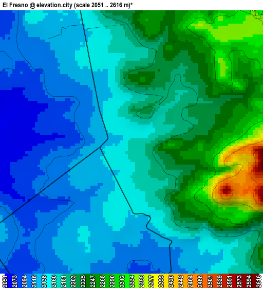
Below is the Elevation map of El Fresno, which displays elevation range with different colors. Scale of the first map is from 2051 to 2616 m (6729 to 8583 ft) with average elevation of 2177.4 meters (=7144 ft) [note 1]
These maps also provides idea of topography and contour of this city, they are displayed at different zoom levels. More info about maps, scale and edge coordinates you can find below images.
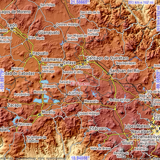
| \ | Map #1 | Topo.Map |
| Scale [m] | 2051..2616 m | × |
| Scale [ft] | 6729..8583 ft | × |
| Average | 2177.4 m = 7144 ft | × |
| Width | 9.17 km = 5.7 mi | 293.3 km = 182.2 mi |
| Height | 9.17 km = 5.7 mi | 293.3 km = 182.2 mi |
| ↑Max Latitude | 20.314437° | 21.58665° |
| Latitude at center | 20.27322° | 20.27322° |
| ↓Min Latitude | 20.231992° | 18.94858° |
| ← Min Longitude | -100.535485° | -101.89779° |
| Longitude center | -100.49154° | -100.49154° |
| →Max Longitude | -100.447595° | -99.08529° |
Nearby cities:
Cities around El Fresno sort by population:
• Jerécuaro elevation 1967 m
13.3 km,  187°
187°
• Coroneo 2277 m
15.5 km,  121°
121°
• La Cuevita 2044 m
11.7 km,  308°
308°
• El Jaral 2072 m
15.3 km,  14°
14°
• Estanzuela de Romero 2022 m
9.9 km, 187°
• Bravo 2130 m
15.7 km,  26°
26°
• San Lucas 2073 m
6.7 km,  289°
289°
• San Isidro de Gamboa 2023 m
14 km,  344°
344°
• Piedras de Lumbre 2281 m
11.6 km,  257°
257°
• Ojo de Agua de Mendoza 1988 m
14.4 km,  214°
214°
• Ceja de Bravo 2171 m
15.5 km,  40°
40°
• San José Tepuzas 2229 m
15.1 km,  53°
53°
Multilingual:
 En español:
El Fresno elevación 2167 m.
 En France:
El Fresno élévation 2167 m.
 Auf Deutsch:
El Fresno höhe über dem Meeresspiegel ist 2167 m.

Sources and notes:
- [note 1] Map square and city borders are not equal. Map elevation data is calculated only from area inside that square.
- [src 1] Elevation data from geonames database provided with same terms of usage.
- [src 2] The elevation map of El Fresno is generated using elevation data from NASA's 3 arcsec (90m) resolution SRTM data.
- [src 3] Base (background) map © OpenStreetMap contributors tiles are generated by Geofabrik and OpenTopoMap.
Copyright & License:
This El Fresno Elevation Map is licensed under CC BY-SA. You may reuse any part from this page, if you give a proper credit by linking to this URL:
 More info on terms of use page.