El Jaral elevation
El Jaral (Querétaro, Corregidora), Mexico elevation is 2072 meters and El Jaral elevation in feet is 6798 ft above sea level [src 1]. El Jaral is a populated place (feature code) with elevation that is 758 meters (2487 ft) bigger than average city elevation in Mexico.
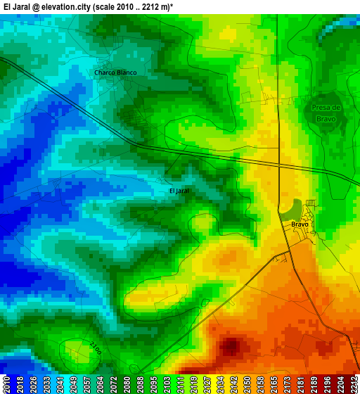
Below is the Elevation map of El Jaral, which displays elevation range with different colors. Scale of the first map is from 2010 to 2212 m (6594 to 7257 ft) with average elevation of 2091.4 meters (=6862 ft) [note 1]
These maps also provides idea of topography and contour of this city, they are displayed at different zoom levels. More info about maps, scale and edge coordinates you can find below images.
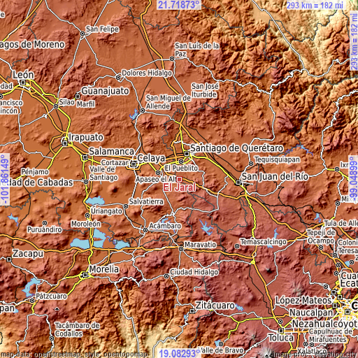
| \ | Map #1 | Topo.Map |
| Scale [m] | 2010..2212 m | × |
| Scale [ft] | 6594..7257 ft | × |
| Average | 2091.4 m = 6862 ft | × |
| Width | 9.16 km = 5.7 mi | 293.1 km = 182.1 mi |
| Height | 9.16 km = 5.7 mi | 293.1 km = 182.1 mi |
| ↑Max Latitude | 20.447652° | 21.71873° |
| Latitude at center | 20.40647° | 20.40647° |
| ↓Min Latitude | 20.365277° | 19.08293° |
| ← Min Longitude | -100.499185° | -101.86149° |
| Longitude center | -100.45524° | -100.45524° |
| →Max Longitude | -100.411295° | -99.04899° |
Nearby cities:
Cities around El Jaral sort by population:
• El Vegil elevation 2052 m
11.3 km,  75°
75°
• Las Taponas 2075 m
7.5 km, 80°
• San Antonio Calichar 1858 m
12 km,  327°
327°
• Joaquín Herrera 2033 m
8.7 km,  11°
11°
• Charco Blanco 2063 m
3.6 km, 329°
• Bravo 2130 m
3.3 km,  102°
102°
• El Espejo 1931 m
11 km,  290°
290°
• San Isidro de Gamboa 2023 m
7.6 km,  260°
260°
• Apapátaro 1967 m
11.3 km,  52°
52°
• Ceja de Bravo 2171 m
7.1 km,  116°
116°
• El Salto de Espejo 2012 m
7.2 km,  312°
312°
• San José Tepuzas 2229 m
10.2 km, 124°
Multilingual:
 En español:
El Jaral elevación 2072 m.
 En France:
El Jaral élévation 2072 m.
 Auf Deutsch:
El Jaral höhe über dem Meeresspiegel ist 2072 m.

Sources and notes:
- [note 1] Map square and city borders are not equal. Map elevation data is calculated only from area inside that square.
- [src 1] Elevation data from geonames database provided with same terms of usage.
- [src 2] The elevation map of El Jaral is generated using elevation data from NASA's 3 arcsec (90m) resolution SRTM data.
- [src 3] Base (background) map © OpenStreetMap contributors tiles are generated by Geofabrik and OpenTopoMap.
Copyright & License:
This El Jaral Elevation Map is licensed under CC BY-SA. You may reuse any part from this page, if you give a proper credit by linking to this URL:
 More info on terms of use page.