Apapátaro elevation
Apapátaro (Querétaro, Huimilpan), Mexico elevation is 1967 meters and Apapátaro elevation in feet is 6453 ft above sea level [src 1]. Apapátaro is a populated place (feature code) with elevation that is 653 meters (2142 ft) bigger than average city elevation in Mexico.
Below is the Elevation map of Apapátaro, which displays elevation range with different colors. Scale of the first map is from 1895 to 2297 m (6217 to 7536 ft) with average elevation of 2013.6 meters (=6606 ft) [note 1]
These maps also provides idea of topography and contour of this city, they are displayed at different zoom levels. More info about maps, scale and edge coordinates you can find below images.
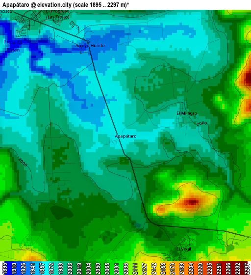
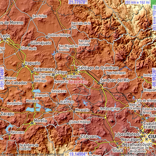
| \ | Map #1 | Topo.Map |
| Scale [m] | 1895..2297 m | × |
| Scale [ft] | 6217..7536 ft | × |
| Average | 2013.6 m = 6606 ft | × |
| Width | 9.16 km = 5.7 mi | 293 km = 182.1 mi |
| Height | 9.16 km = 5.7 mi | 293 km = 182.1 mi |
| ↑Max Latitude | 20.509225° | 21.77978° |
| Latitude at center | 20.46806° | 20.46806° |
| ↓Min Latitude | 20.426884° | 19.14504° |
| ← Min Longitude | -100.412555° | -101.77486° |
| Longitude center | -100.36861° | -100.36861° |
| →Max Longitude | -100.324665° | -98.96236° |
Nearby cities:
Cities around Apapátaro sort by population:
• San Jose de los Olvera elevation 1857 m
10.6 km,  332°
332°
• Venceremos 1896 m
9.7 km,  341°
341°
• Los Olvera 1870 m
8.4 km, 330°
• El Vegil 2052 m
4.5 km,  155°
155°
• Lagunillas 2152 m
7.7 km,  97°
97°
• Las Taponas 2075 m
5.9 km,  196°
196°
• Joaquín Herrera 2033 m
7.5 km,  282°
282°
• La Noria 2004 m
5.5 km,  25°
25°
• El Milagro 1993 m
2.1 km,  71°
71°
• El Rosario 2102 m
8.8 km,  44°
44°
• Bravo 2130 m
9.6 km,  217°
217°
• Ceja de Bravo 2171 m
10.3 km, 195°
Multilingual:
 En español:
Apapátaro elevación 1967 m.
 En France:
Apapátaro élévation 1967 m.
 Auf Deutsch:
Apapátaro höhe über dem Meeresspiegel ist 1967 m.

Sources and notes:
- [note 1] Map square and city borders are not equal. Map elevation data is calculated only from area inside that square.
- [src 1] Elevation data from geonames database provided with same terms of usage.
- [src 2] The elevation map of Apapátaro is generated using elevation data from NASA's 3 arcsec (90m) resolution SRTM data.
- [src 3] Base (background) map © OpenStreetMap contributors tiles are generated by Geofabrik and OpenTopoMap.
Copyright & License:
This Apapátaro Elevation Map is licensed under CC BY-SA. You may reuse any part from this page, if you give a proper credit by linking to this URL:
 More info on terms of use page.