Tungareo elevation
Tungareo (Michoacán, Maravatío), Mexico elevation is 2029 meters and Tungareo elevation in feet is 6657 ft above sea level [src 1]. Tungareo is a populated place (feature code) with elevation that is 715 meters (2346 ft) bigger than average city elevation in Mexico.
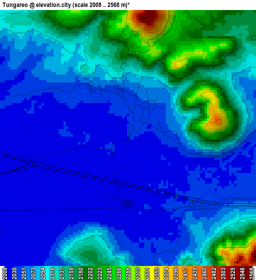
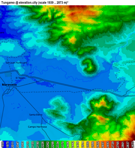
Below is the Elevation map of Tungareo, which displays elevation range with different colors. Scale of the first map is from 2008 to 2568 m (6588 to 8425 ft) with average elevation of 2092.2 meters (=6864 ft) [note 1]
These maps also provides idea of topography and contour of this city, they are displayed at different zoom levels. More info about maps, scale and edge coordinates you can find below images.
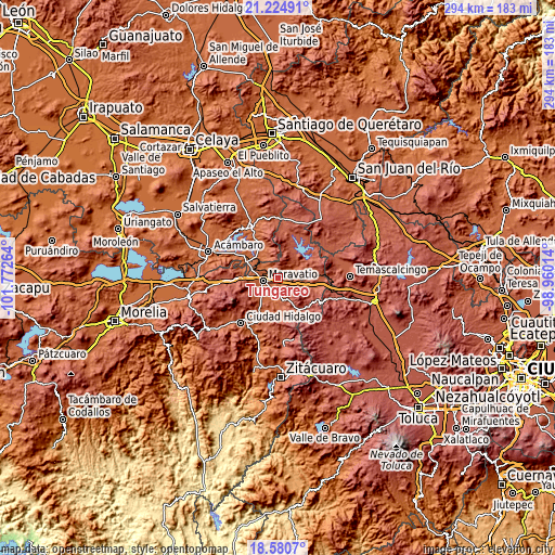
| \ | Map #1 | Map #2 | Topo.Map |
| Scale [m] | 2008..2568 m | 1939..2873 m | × |
| Scale [ft] | 6588..8425 ft | 6362..9426 ft | × |
| Average | 2092.2 m = 6864 ft | 2155.3 m = 7071 ft | × |
| Width | 9.19 km = 5.7 mi | 18.38 km = 11.4 mi | 294 km = 182.7 mi |
| Height | 9.19 km = 5.7 mi | 18.38 km = 11.4 mi | 294 km = 182.7 mi |
| ↑Max Latitude | 19.949644° | 19.990947° | 21.22491° |
| Latitude at center | 19.90833° | 19.90833° | 19.90833° |
| ↓Min Latitude | 19.867006° | 19.82567° | 18.5807° |
| ← Min Longitude | -100.410335° | -100.454281° | -101.77264° |
| Longitude center | -100.36639° | -100.36639° | -100.36639° |
| →Max Longitude | -100.322445° | -100.278499° | -98.96014° |
Nearby cities:
Cities around Tungareo sort by population:
• Maravatío de Ocampo elevation 2019 m
8.4 km,  256°
256°
• Buenavista 2257 m
14.3 km,  87°
87°
• Apeo 2033 m
3.5 km,  132°
132°
• Santa Elena 2032 m
7.1 km,  218°
218°
• Tepuxtepec 2369 m
17.4 km,  57°
57°
• Tupátaro 2425 m
12.3 km,  148°
148°
• Uripitio 2021 m
18.6 km,  285°
285°
• Tziritzícuaro 1973 m
11.1 km,  298°
298°
• Atotonilco 2322 m
15.4 km,  76°
76°
• San Pedro Tarímbaro 2599 m
18.5 km, 127°
• Dolores 2434 m
17.6 km,  15°
15°
• La Higuerilla (Los Lirios) 2139 m
9.5 km, 80°
Multilingual:
 En español:
Tungareo elevación 2029 m.
 En France:
Tungareo élévation 2029 m.
 Auf Deutsch:
Tungareo höhe über dem Meeresspiegel ist 2029 m.

Sources and notes:
- [note 1] Map square and city borders are not equal. Map elevation data is calculated only from area inside that square.
- [src 1] Elevation data from geonames database provided with same terms of usage.
- [src 2] The elevation map of Tungareo is generated using elevation data from NASA's 3 arcsec (90m) resolution SRTM data.
- [src 3] Base (background) map © OpenStreetMap contributors tiles are generated by Geofabrik and OpenTopoMap.
Copyright & License:
This Tungareo Elevation Map is licensed under CC BY-SA. You may reuse any part from this page, if you give a proper credit by linking to this URL:
 More info on terms of use page.