Apeo elevation
Apeo (Michoacán, Maravatío), Mexico elevation is 2033 meters and Apeo elevation in feet is 6670 ft above sea level [src 1]. Apeo is a populated place (feature code) with elevation that is 719 meters (2359 ft) bigger than average city elevation in Mexico.
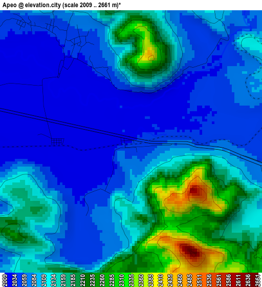
Below is the Elevation map of Apeo, which displays elevation range with different colors. Scale of the first map is from 2009 to 2661 m (6591 to 8730 ft) with average elevation of 2114.4 meters (=6937 ft) [note 1]
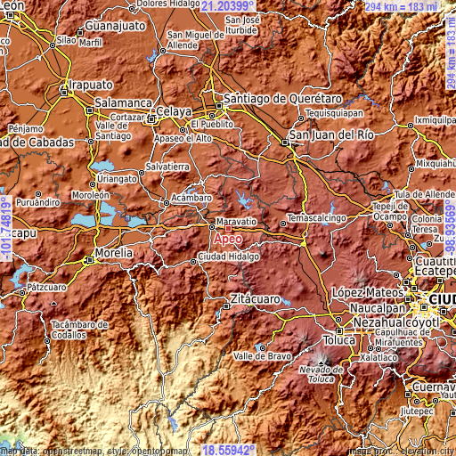
These maps also provides idea of topography and contour of this city, they are displayed at different zoom levels. More info about maps, scale and edge coordinates you can find below images.
| \ | Map #1 | Topo.Map |
| Scale [m] | 2009..2661 m | × |
| Scale [ft] | 6591..8730 ft | × |
| Average | 2114.4 m = 6937 ft | × |
| Width | 9.19 km = 5.7 mi | 294 km = 182.7 mi |
| Height | 9.19 km = 5.7 mi | 294.1 km = 182.7 mi |
| ↑Max Latitude | 19.928539° | 21.20399° |
| Latitude at center | 19.88722° | 19.88722° |
| ↓Min Latitude | 19.84589° | 18.55942° |
| ← Min Longitude | -100.385885° | -101.74819° |
| Longitude center | -100.34194° | -100.34194° |
| →Max Longitude | -100.297995° | -98.93569° |
Nearby cities:
Cities around Apeo sort by population:
• Maravatío de Ocampo elevation 2019 m
10.7 km,  272°
272°
• Tungareo 2029 m
3.5 km,  312°
312°
• Senguio 2275 m
17.1 km,  184°
184°
• Buenavista 2257 m
12.1 km,  75°
75°
• Santa Elena 2032 m
7.6 km,  245°
245°
• Tepuxtepec 2369 m
16.8 km,  46°
46°
• Tupátaro 2425 m
9 km,  154°
154°
• Tziritzícuaro 1973 m
14.5 km,  301°
301°
• Atotonilco 2322 m
13.8 km,  64°
64°
• San Pedro Tarímbaro 2599 m
15 km,  125°
125°
• La Higuerilla (Los Lirios) 2139 m
7.9 km, 60°
• Agua Caliente 2306 m
17.8 km,  85°
85°
Multilingual:
 En español:
Apeo elevación 2033 m.
 En France:
Apeo élévation 2033 m.


Sources and notes:
- [note 1] Map square and city borders are not equal. Map elevation data is calculated only from area inside that square.
- [src 1] Elevation data from geonames database provided with same terms of usage.
- [src 2] The elevation map of Apeo is generated using elevation data from NASA's 3 arcsec (90m) resolution SRTM data.
- [src 3] Base (background) map © OpenStreetMap contributors tiles are generated by Geofabrik and OpenTopoMap.
Copyright & License:
This Apeo Elevation Map is licensed under CC BY-SA. You may reuse any part from this page, if you give a proper credit by linking to this URL:
 More info on terms of use page.