Agostitlán elevation
Agostitlán (Michoacán, Hidalgo), Mexico elevation is 2535 meters and Agostitlán elevation in feet is 8317 ft above sea level [src 1]. Agostitlán is a populated place (feature code) with elevation that is 1221 meters (4006 ft) bigger than average city elevation in Mexico.
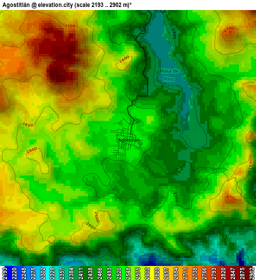
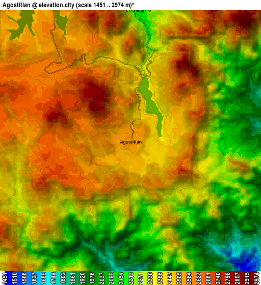
Below is the Elevation map of Agostitlán, which displays elevation range with different colors. Scale of the first map is from 2193 to 2902 m (7195 to 9521 ft) with average elevation of 2537.1 meters (=8324 ft) [note 1]
These maps also provides idea of topography and contour of this city, they are displayed at different zoom levels. More info about maps, scale and edge coordinates you can find below images.
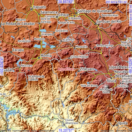
| \ | Map #1 | Map #2 | Topo.Map |
| Scale [m] | 2193..2902 m | 1451..2974 m | × |
| Scale [ft] | 7195..9521 ft | 4760..9757 ft | × |
| Average | 2537.1 m = 8324 ft | 2396.3 m = 7862 ft | × |
| Width | 9.21 km = 5.7 mi | 18.42 km = 11.4 mi | 294.7 km = 183.1 mi |
| Height | 9.21 km = 5.7 mi | 18.42 km = 11.4 mi | 294.7 km = 183.1 mi |
| ↑Max Latitude | 19.57959° | 19.620989° | 20.85792° |
| Latitude at center | 19.53818° | 19.53818° | 19.53818° |
| ↓Min Latitude | 19.49676° | 19.455329° | 18.20757° |
| ← Min Longitude | -100.662435° | -100.706381° | -102.02474° |
| Longitude center | -100.61849° | -100.61849° | -100.61849° |
| →Max Longitude | -100.574545° | -100.530599° | -99.21224° |
Nearby cities:
Cities around Agostitlán sort by population:
• Ciudad Hidalgo elevation 2062 m
18.4 km,  21°
21°
• Tuxpan 1732 m
16.7 km,  78°
78°
• Jungapeo de Juárez 1314 m
15.7 km,  124°
124°
• San Bartolo Cuitareo 2158 m
12.7 km,  8°
8°
• San Antonio Villalongín 2189 m
14.1 km,  268°
268°
• Lázaro Cárdenas 1586 m
14.9 km,  111°
111°
• Rincón de Cedeños (Rincón de Dolores) 2116 m
16.2 km, 15°
• Colonia Ecológica Asociación de Lucha Social (Lucha Social) 2103 m
16.7 km,  3°
3°
• San Lucas Huarirapeo (La Mesa de San Lucas) 2138 m
15.6 km,  357°
357°
• Santa Ana 1757 m
16.4 km,  72°
72°
• La Soledad 1763 m
14.3 km,  97°
97°
• Colonia el Mirador (Llano del Ejido) 2067 m
16.7 km, 23°
Multilingual:
 En español:
Agostitlán elevación 2535 m.
 En France:
Agostitlán élévation 2535 m.
 Auf Deutsch:
Agostitlán höhe über dem Meeresspiegel ist 2535 m.

Sources and notes:
- [note 1] Map square and city borders are not equal. Map elevation data is calculated only from area inside that square.
- [src 1] Elevation data from geonames database provided with same terms of usage.
- [src 2] The elevation map of Agostitlán is generated using elevation data from NASA's 3 arcsec (90m) resolution SRTM data.
- [src 3] Base (background) map © OpenStreetMap contributors tiles are generated by Geofabrik and OpenTopoMap.
Copyright & License:
This Agostitlán Elevation Map is licensed under CC BY-SA. You may reuse any part from this page, if you give a proper credit by linking to this URL:
 More info on terms of use page.