Tuxpan elevation
Tuxpan (Michoacán), Mexico elevation is 1732 meters and Tuxpan elevation in feet is 5682 ft above sea level [src 1]. Tuxpan is a seat of a second-order administrative division (feature code) with elevation that is 418 meters (1371 ft) bigger than average city elevation in Mexico.
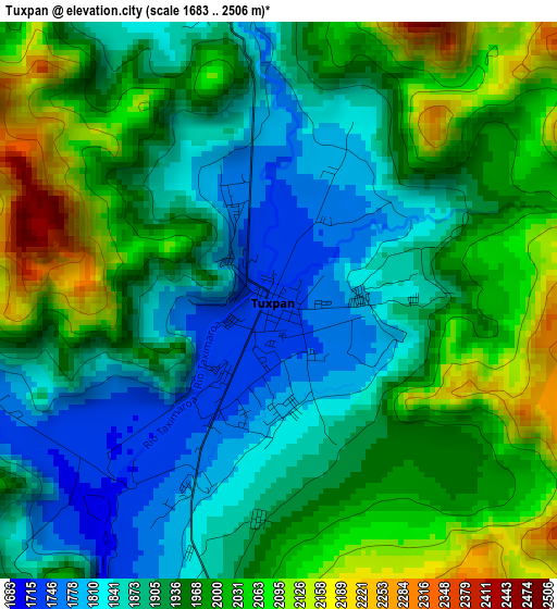
Below is the Elevation map of Tuxpan, which displays elevation range with different colors. Scale of the first map is from 1683 to 2506 m (5522 to 8222 ft) with average elevation of 1944.5 meters (=6380 ft) [note 1]
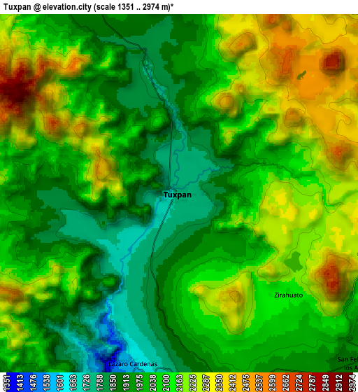
These maps also provides idea of topography and contour of this city, they are displayed at different zoom levels. More info about maps, scale and edge coordinates you can find below images.
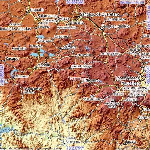
| \ | Map #1 | Map #2 | Topo.Map |
| Scale [m] | 1683..2506 m | 1351..2974 m | × |
| Scale [ft] | 5522..8222 ft | 4432..9757 ft | × |
| Average | 1944.5 m = 6380 ft | 2077.9 m = 6817 ft | × |
| Width | 9.21 km = 5.7 mi | 18.42 km = 11.4 mi | 294.6 km = 183.1 mi |
| Height | 9.21 km = 5.7 mi | 18.42 km = 11.4 mi | 294.7 km = 183.1 mi |
| ↑Max Latitude | 19.609282° | 19.650673° | 20.88736° |
| Latitude at center | 19.56788° | 19.56788° | 19.56788° |
| ↓Min Latitude | 19.526467° | 19.485044° | 18.23751° |
| ← Min Longitude | -100.505835° | -100.549781° | -101.86814° |
| Longitude center | -100.46189° | -100.46189° | -100.46189° |
| →Max Longitude | -100.417945° | -100.373999° | -99.05564° |
Nearby cities:
Cities around Tuxpan sort by population:
• Jungapeo de Juárez elevation 1314 m
12.6 km,  195°
195°
• San Felipe los Alzati (Colonia Nueva) 1898 m
12.7 km,  133°
133°
• San Lorenzo Queréndaro 1949 m
11.4 km,  345°
345°
• Aporo 2289 m
12.6 km,  25°
25°
• Zirahuato de los Bernal 2126 m
7.8 km, 131°
• Lázaro Cárdenas 1586 m
9 km, 196°
• El Rincón de San Felipe (Tercera Manzana San Felipe) 1946 m
11.6 km, 126°
• Santa Ana 1757 m
1.8 km,  335°
335°
• Ocurio 1948 m
10.3 km,  156°
156°
• La Soledad 1763 m
5.7 km, 203°
• Manzana la Cofradía 2297 m
11.3 km,  100°
100°
• Puentecillas (Tercera Manzana de Zirahuato) 2039 m
9.2 km,  139°
139°
Multilingual:
 En español:
Tuxpan elevación 1732 m.
 En France:
Tuxpan élévation 1732 m.


Sources and notes:
- [note 1] Map square and city borders are not equal. Map elevation data is calculated only from area inside that square.
- [src 1] Elevation data from geonames database provided with same terms of usage.
- [src 2] The elevation map of Tuxpan is generated using elevation data from NASA's 3 arcsec (90m) resolution SRTM data.
- [src 3] Base (background) map © OpenStreetMap contributors tiles are generated by Geofabrik and OpenTopoMap.
Copyright & License:
This Tuxpan Elevation Map is licensed under CC BY-SA. You may reuse any part from this page, if you give a proper credit by linking to this URL:
 More info on terms of use page.