Jungapeo de Juárez elevation
Jungapeo de Juárez (Michoacán, Jungapeo), Mexico elevation is 1314 meters and Jungapeo de Juárez elevation in feet is 4311 ft above sea level [src 1]. Jungapeo de Juárez is a seat of a second-order administrative division (feature code) with elevation that is 0 meters (0 ft) bigger than average city elevation in Mexico.
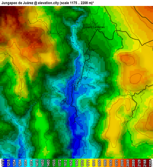
Below is the Elevation map of Jungapeo de Juárez, which displays elevation range with different colors. Scale of the first map is from 1175 to 2208 m (3855 to 7244 ft) with average elevation of 1631.3 meters (=5352 ft) [note 1]
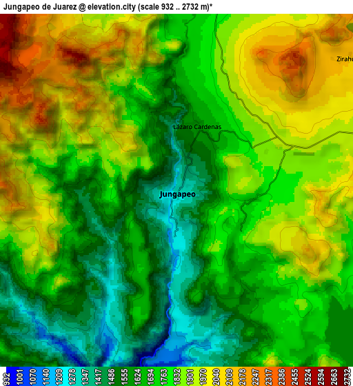
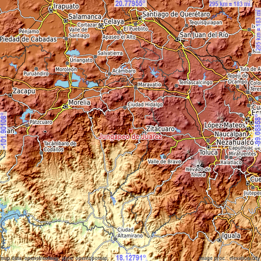
These maps also provides idea of topography and contour of this city, they are displayed at different zoom levels. More info about maps, scale and edge coordinates you can find below images.
| \ | Map #1 | Map #2 | Topo.Map |
| Scale [m] | 1175..2208 m | 932..2732 m | × |
| Scale [ft] | 3855..7244 ft | 3058..8963 ft | × |
| Average | 1631.3 m = 5352 ft | 1776.9 m = 5830 ft | × |
| Width | 9.21 km = 5.7 mi | 18.43 km = 11.5 mi | 294.8 km = 183.2 mi |
| Height | 9.21 km = 5.7 mi | 18.43 km = 11.5 mi | 294.9 km = 183.2 mi |
| ↑Max Latitude | 19.50058° | 19.541999° | 20.77955° |
| Latitude at center | 19.45915° | 19.45915° | 19.45915° |
| ↓Min Latitude | 19.41771° | 19.376259° | 18.12791° |
| ← Min Longitude | -100.538775° | -100.582721° | -101.90108° |
| Longitude center | -100.49483° | -100.49483° | -100.49483° |
| →Max Longitude | -100.450885° | -100.406939° | -99.08858° |
Nearby cities:
Cities around Jungapeo de Juárez sort by population:
• Tuxpan elevation 1732 m
12.6 km,  15°
15°
• San Felipe los Alzati (Colonia Nueva) 1898 m
13.1 km,  74°
74°
• Zirahuato de los Bernal 2126 m
11.5 km,  53°
53°
• Lázaro Cárdenas 1586 m
3.5 km, 15°
• El Rincón de San Felipe (Tercera Manzana San Felipe) 1946 m
13.8 km, 67°
• La Encarnación 1733 m
12 km,  115°
115°
• Santa Ana 1757 m
14 km,  11°
11°
• Ocurio 1948 m
7.9 km, 70°
• La Soledad 1763 m
7 km, 9°
• Huanguitío 1269 m
6.9 km,  173°
173°
• Puentecillas (Tercera Manzana de Zirahuato) 2039 m
10.7 km,  61°
61°
• Camémbaro 1740 m
10.7 km,  109°
109°
Multilingual:
 En español:
Jungapeo de Juárez elevación 1314 m.
 En France:
Jungapeo de Juárez élévation 1314 m.
 Auf Deutsch:
Jungapeo de Juárez höhe über dem Meeresspiegel ist 1314 m.
 На русском:
Jungapeo de Juárez высота над уровнем моря 1314 м
Sources and notes:
- [note 1] Map square and city borders are not equal. Map elevation data is calculated only from area inside that square.
- [src 1] Elevation data from geonames database provided with same terms of usage.
- [src 2] The elevation map of Jungapeo de Juárez is generated using elevation data from NASA's 3 arcsec (90m) resolution SRTM data.
- [src 3] Base (background) map © OpenStreetMap contributors tiles are generated by Geofabrik and OpenTopoMap.
Copyright & License:
This Jungapeo de Juárez Elevation Map is licensed under CC BY-SA. You may reuse any part from this page, if you give a proper credit by linking to this URL:
 More info on terms of use page.