Huanguitío elevation
Huanguitío (Michoacán, Jungapeo), Mexico elevation is 1269 meters and Huanguitío elevation in feet is 4163 ft above sea level [src 1]. Huanguitío is a populated place (feature code) with elevation that is 45 meters (148 ft) smaller than average city elevation in Mexico.
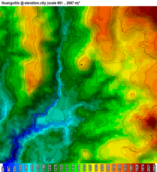
Below is the Elevation map of Huanguitío, which displays elevation range with different colors. Scale of the first map is from 861 to 2067 m (2825 to 6781 ft) with average elevation of 1427.2 meters (=4682 ft) [note 1]
These maps also provides idea of topography and contour of this city, they are displayed at different zoom levels. More info about maps, scale and edge coordinates you can find below images.
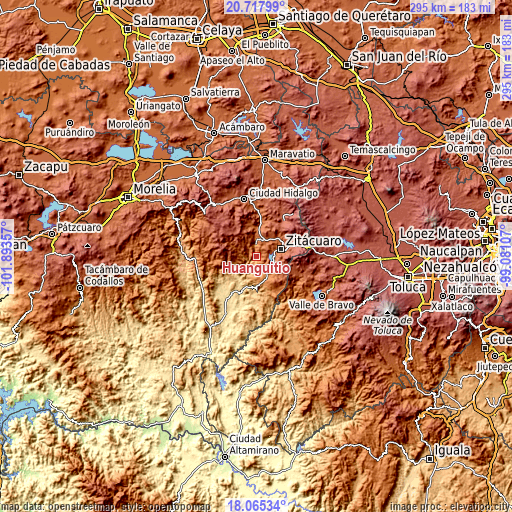
| \ | Map #1 | Topo.Map |
| Scale [m] | 861..2067 m | × |
| Scale [ft] | 2825..6781 ft | × |
| Average | 1427.2 m = 4682 ft | × |
| Width | 9.22 km = 5.7 mi | 294.9 km = 183.2 mi |
| Height | 9.22 km = 5.7 mi | 295 km = 183.3 mi |
| ↑Max Latitude | 19.438516° | 20.71799° |
| Latitude at center | 19.39707° | 19.39707° |
| ↓Min Latitude | 19.355614° | 18.06534° |
| ← Min Longitude | -100.531265° | -101.89357° |
| Longitude center | -100.48732° | -100.48732° |
| →Max Longitude | -100.443375° | -99.08107° |
Nearby cities:
Cities around Huanguitío sort by population:
• Heróica Zitácuaro elevation 1958 m
14.3 km,  72°
72°
• Jungapeo de Juárez 1314 m
6.9 km,  353°
353°
• Benito Juárez 1325 m
10.9 km,  148°
148°
• Parícuaro 1280 m
15.4 km,  168°
168°
• Lázaro Cárdenas 1586 m
10.3 km,  0°
0°
• La Encarnación 1733 m
10.1 km,  80°
80°
• Ocurio 1948 m
11.6 km,  35°
35°
• Santa Ana de Guerrero (El Cascabel) 1313 m
14.3 km,  160°
160°
• La Soledad 1763 m
13.8 km, 1°
• Cerro Colorado de Ocampo 1245 m
9.2 km, 165°
• Puentecillas (Tercera Manzana de Zirahuato) 2039 m
14.8 km, 35°
• Camémbaro 1740 m
9.9 km, 70°
Multilingual:
 En español:
Huanguitío elevación 1269 m.
 En France:
Huanguitío élévation 1269 m.
 Auf Deutsch:
Huanguitío höhe über dem Meeresspiegel ist 1269 m.

Sources and notes:
- [note 1] Map square and city borders are not equal. Map elevation data is calculated only from area inside that square.
- [src 1] Elevation data from geonames database provided with same terms of usage.
- [src 2] The elevation map of Huanguitío is generated using elevation data from NASA's 3 arcsec (90m) resolution SRTM data.
- [src 3] Base (background) map © OpenStreetMap contributors tiles are generated by Geofabrik and OpenTopoMap.
Copyright & License:
This Huanguitío Elevation Map is licensed under CC BY-SA. You may reuse any part from this page, if you give a proper credit by linking to this URL:
 More info on terms of use page.