Benito Juárez elevation
Benito Juárez (Michoacán, Juárez), Mexico elevation is 1325 meters and Benito Juárez elevation in feet is 4347 ft above sea level [src 1]. Benito Juárez is a seat of a second-order administrative division (feature code) with elevation that is 11 meters (36 ft) bigger than average city elevation in Mexico.
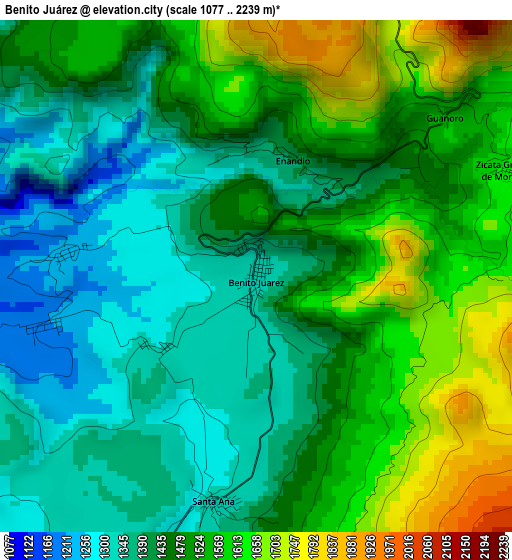
Below is the Elevation map of Benito Juárez, which displays elevation range with different colors. Scale of the first map is from 1077 to 2239 m (3533 to 7346 ft) with average elevation of 1474.7 meters (=4838 ft) [note 1]
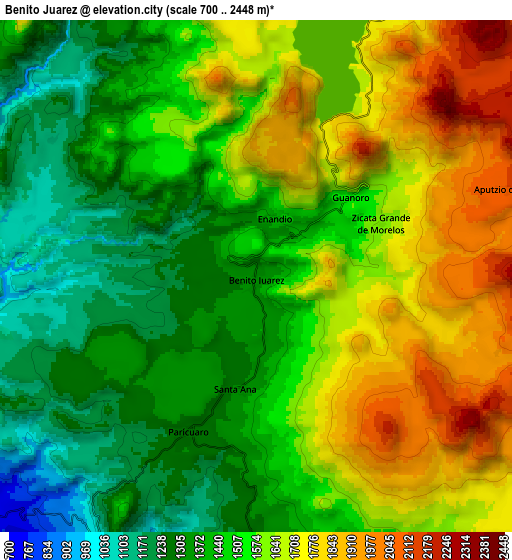
These maps also provides idea of topography and contour of this city, they are displayed at different zoom levels. More info about maps, scale and edge coordinates you can find below images.
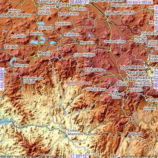
| \ | Map #1 | Map #2 | Topo.Map |
| Scale [m] | 1077..2239 m | 700..2448 m | × |
| Scale [ft] | 3533..7346 ft | 2297..8031 ft | × |
| Average | 1474.7 m = 4838 ft | 1533.9 m = 5032 ft | × |
| Width | 9.22 km = 5.7 mi | 18.45 km = 11.5 mi | 295.1 km = 183.4 mi |
| Height | 9.22 km = 5.7 mi | 18.45 km = 11.5 mi | 295.1 km = 183.4 mi |
| ↑Max Latitude | 19.354977° | 19.396433° | 20.63513° |
| Latitude at center | 19.31351° | 19.31351° | 19.31351° |
| ↓Min Latitude | 19.272033° | 19.230545° | 17.98112° |
| ← Min Longitude | -100.477525° | -100.521471° | -101.83983° |
| Longitude center | -100.43358° | -100.43358° | -100.43358° |
| →Max Longitude | -100.389635° | -100.345689° | -99.02733° |
Nearby cities:
Cities around Benito Juárez sort by population:
• Heróica Zitácuaro elevation 1958 m
15.8 km,  30°
30°
• Benito Juárez 1129 m
9.6 km,  201°
201°
• Parícuaro 1280 m
6.4 km, 204°
• La Encarnación 1733 m
11.8 km,  21°
21°
• Rancho Viejo 1564 m
7.4 km,  166°
166°
• Aputzio de Juárez 2114 m
9.6 km,  70°
70°
• Barrio de Arriba de San Juan Xoconusco 2140 m
17.2 km,  87°
87°
• Santa Ana de Guerrero (El Cascabel) 1313 m
4.2 km,  191°
191°
• Cerro Colorado de Ocampo 1245 m
3.4 km,  276°
276°
• Huanguitío 1269 m
10.9 km,  328°
328°
• Camémbaro 1740 m
13.2 km, 16°
• Susupuato de Guerrero 1257 m
11.3 km, 166°
Multilingual:
 En español:
Benito Juárez, Laureles elevación 1325 m.
 En France:
Benito Juárez élévation 1325 m.
 Auf Deutsch:
Benito Juárez höhe über dem Meeresspiegel ist 1325 m.

Sources and notes:
- [note 1] Map square and city borders are not equal. Map elevation data is calculated only from area inside that square.
- [src 1] Elevation data from geonames database provided with same terms of usage.
- [src 2] The elevation map of Benito Juárez is generated using elevation data from NASA's 3 arcsec (90m) resolution SRTM data.
- [src 3] Base (background) map © OpenStreetMap contributors tiles are generated by Geofabrik and OpenTopoMap.
Copyright & License:
This Benito Juárez Elevation Map is licensed under CC BY-SA. You may reuse any part from this page, if you give a proper credit by linking to this URL:
 More info on terms of use page.