Aputzio de Juárez elevation
Aputzio de Juárez (Michoacán, Zitácuaro), Mexico elevation is 2114 meters and Aputzio de Juárez elevation in feet is 6936 ft above sea level [src 1]. Aputzio de Juárez is a populated place (feature code) with elevation that is 800 meters (2625 ft) bigger than average city elevation in Mexico.
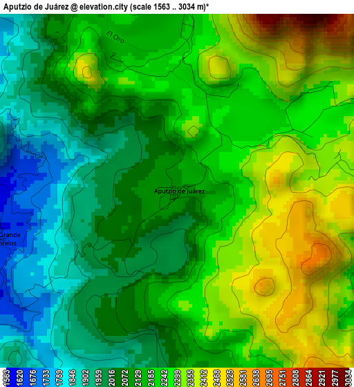
Below is the Elevation map of Aputzio de Juárez, which displays elevation range with different colors. Scale of the first map is from 1563 to 3034 m (5128 to 9954 ft) with average elevation of 2159.3 meters (=7084 ft) [note 1]
These maps also provides idea of topography and contour of this city, they are displayed at different zoom levels. More info about maps, scale and edge coordinates you can find below images.
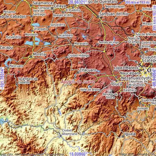
| \ | Map #1 | Topo.Map |
| Scale [m] | 1563..3034 m | × |
| Scale [ft] | 5128..9954 ft | × |
| Average | 2159.3 m = 7084 ft | × |
| Width | 9.22 km = 5.7 mi | 295 km = 183.3 mi |
| Height | 9.22 km = 5.7 mi | 295.1 km = 183.4 mi |
| ↑Max Latitude | 19.38329° | 20.66321° |
| Latitude at center | 19.34183° | 19.34183° |
| ↓Min Latitude | 19.30036° | 18.00966° |
| ← Min Longitude | -100.390835° | -101.75314° |
| Longitude center | -100.34689° | -100.34689° |
| →Max Longitude | -100.302945° | -98.94064° |
Nearby cities:
Cities around Aputzio de Juárez sort by population:
• Heróica Zitácuaro elevation 1958 m
10.5 km,  354°
354°
• Rincón de Nicolás Romero (Cedros Tercera Manzana) 2325 m
9.5 km,  32°
32°
• Benito Juárez 1325 m
9.6 km,  250°
250°
• San Juan Xoconusco 2067 m
9.8 km,  110°
110°
• Colonia Emiliano Zapata (San Juan Zitácuaro) 2193 m
12.5 km,  20°
20°
• La Encarnación 1733 m
9.2 km,  328°
328°
• Rancho Viejo 1564 m
12.7 km,  215°
215°
• La Mesa (La Mesa de Cedano) 2156 m
12.1 km,  9°
9°
• Barrio de Arriba de San Juan Xoconusco 2140 m
8.4 km, 106°
• Santa Ana de Guerrero (El Cascabel) 1313 m
12.3 km,  233°
233°
• Camémbaro 1740 m
10.9 km, 330°
• Ixtapan del Oro 1670 m
12.3 km,  135°
135°
Multilingual:
 En español:
Aputzio de Juárez, Santa María elevación 2114 m.
 En France:
Aputzio de Juárez élévation 2114 m.
 Auf Deutsch:
Aputzio de Juárez höhe über dem Meeresspiegel ist 2114 m.
 На русском:
Aputzio de Juárez высота над уровнем моря 2114 м
Sources and notes:
- [note 1] Map square and city borders are not equal. Map elevation data is calculated only from area inside that square.
- [src 1] Elevation data from geonames database provided with same terms of usage.
- [src 2] The elevation map of Aputzio de Juárez is generated using elevation data from NASA's 3 arcsec (90m) resolution SRTM data.
- [src 3] Base (background) map © OpenStreetMap contributors tiles are generated by Geofabrik and OpenTopoMap.
Copyright & License:
This Aputzio de Juárez Elevation Map is licensed under CC BY-SA. You may reuse any part from this page, if you give a proper credit by linking to this URL:
 More info on terms of use page.