Aporo elevation
Aporo (Michoacán), Mexico elevation is 2289 meters and Aporo elevation in feet is 7510 ft above sea level [src 1]. Aporo is a seat of a second-order administrative division (feature code) with elevation that is 975 meters (3199 ft) bigger than average city elevation in Mexico.
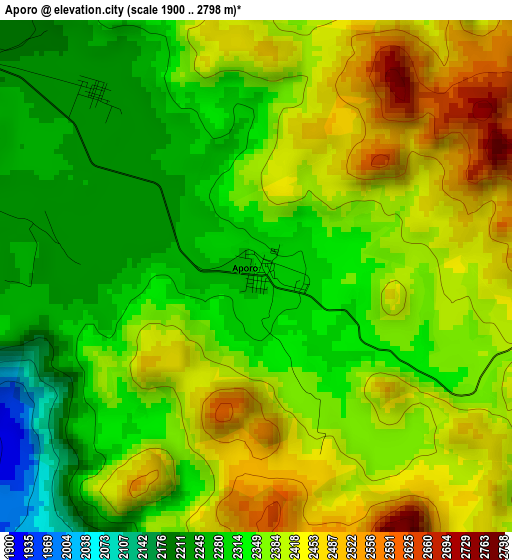
Below is the Elevation map of Aporo, which displays elevation range with different colors. Scale of the first map is from 1900 to 2798 m (6234 to 9180 ft) with average elevation of 2364.6 meters (=7758 ft) [note 1]
These maps also provides idea of topography and contour of this city, they are displayed at different zoom levels. More info about maps, scale and edge coordinates you can find below images.
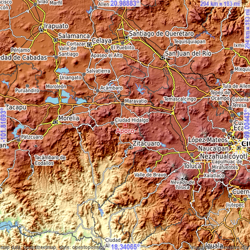
| \ | Map #1 | Topo.Map |
| Scale [m] | 1900..2798 m | × |
| Scale [ft] | 6234..9180 ft | × |
| Average | 2364.6 m = 7758 ft | × |
| Width | 9.2 km = 5.7 mi | 294.5 km = 183 mi |
| Height | 9.2 km = 5.7 mi | 294.5 km = 183 mi |
| ↑Max Latitude | 19.711586° | 20.98883° |
| Latitude at center | 19.67021° | 19.67021° |
| ↓Min Latitude | 19.628824° | 18.34065° |
| ← Min Longitude | -100.454625° | -101.81693° |
| Longitude center | -100.41068° | -100.41068° |
| →Max Longitude | -100.366735° | -99.00443° |
Nearby cities:
Cities around Aporo sort by population:
• Tuxpan elevation 1732 m
12.6 km,  205°
205°
• Mineral de Angangueo 2603 m
14.3 km,  112°
112°
• Ocampo 2301 m
12.3 km,  142°
142°
• Irimbo 2193 m
7.9 km,  295°
295°
• Tzintzingareo 2268 m
13 km,  323°
323°
• Senguio 2275 m
9.3 km,  39°
39°
• San Lorenzo Queréndaro 1949 m
8.2 km,  267°
267°
• Colonia Antorcha Campesina (Santa Rosa) 2060 m
12.1 km,  275°
275°
• Santa Ana 1757 m
11.5 km, 211°
• Aquiles Córdova Morán 2130 m
13.8 km,  287°
287°
• Colonia Aquiles Córdoba Morán 2137 m
13.7 km, 287°
• Colonia Independencia 2354 m
10.9 km,  123°
123°
Multilingual:
 En español:
Aporo elevación 2289 m.
 En France:
Aporo élévation 2289 m.


Sources and notes:
- [note 1] Map square and city borders are not equal. Map elevation data is calculated only from area inside that square.
- [src 1] Elevation data from geonames database provided with same terms of usage.
- [src 2] The elevation map of Aporo is generated using elevation data from NASA's 3 arcsec (90m) resolution SRTM data.
- [src 3] Base (background) map © OpenStreetMap contributors tiles are generated by Geofabrik and OpenTopoMap.
Copyright & License:
This Aporo Elevation Map is licensed under CC BY-SA. You may reuse any part from this page, if you give a proper credit by linking to this URL:
 More info on terms of use page.