Ocampo elevation
Ocampo (Michoacán), Mexico elevation is 2301 meters and Ocampo elevation in feet is 7549 ft above sea level [src 1]. Ocampo is a seat of a second-order administrative division (feature code) with elevation that is 987 meters (3238 ft) bigger than average city elevation in Mexico.
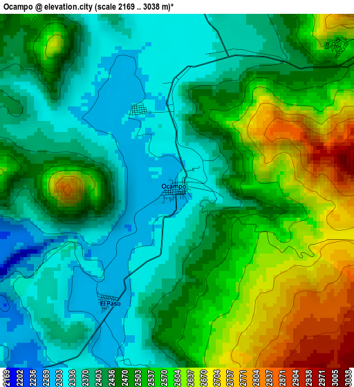
Below is the Elevation map of Ocampo, which displays elevation range with different colors. Scale of the first map is from 2169 to 3038 m (7116 to 9967 ft) with average elevation of 2472.6 meters (=8112 ft) [note 1]
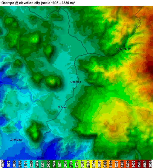
These maps also provides idea of topography and contour of this city, they are displayed at different zoom levels. More info about maps, scale and edge coordinates you can find below images.
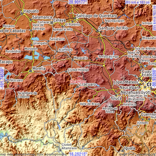
| \ | Map #1 | Map #2 | Topo.Map |
| Scale [m] | 2169..3038 m | 1905..3636 m | × |
| Scale [ft] | 7116..9967 ft | 6250..11929 ft | × |
| Average | 2472.6 m = 8112 ft | 2531.7 m = 8306 ft | × |
| Width | 9.21 km = 5.7 mi | 18.41 km = 11.4 mi | 294.6 km = 183.1 mi |
| Height | 9.21 km = 5.7 mi | 18.41 km = 11.4 mi | 294.6 km = 183.1 mi |
| ↑Max Latitude | 19.623808° | 19.665196° | 20.90177° |
| Latitude at center | 19.58241° | 19.58241° | 19.58241° |
| ↓Min Latitude | 19.541001° | 19.499582° | 18.25215° |
| ← Min Longitude | -100.383075° | -100.427021° | -101.74538° |
| Longitude center | -100.33913° | -100.33913° | -100.33913° |
| →Max Longitude | -100.295185° | -100.251239° | -98.93288° |
Nearby cities:
Cities around Ocampo sort by population:
• Mineral de Angangueo elevation 2603 m
7.1 km,  53°
53°
• Manzana de San Luis 2768 m
6.9 km,  108°
108°
• San Felipe los Alzati (Colonia Nueva) 1898 m
10.9 km,  199°
199°
• Zirahuato de los Bernal 2126 m
9.8 km,  226°
226°
• El Rincón de San Felipe (Tercera Manzana San Felipe) 1946 m
9.2 km, 202°
• Rincón de Curungueo 1954 m
11 km,  182°
182°
• Macutzio 1983 m
9.4 km,  190°
190°
• Colonia Independencia 2354 m
4 km,  23°
23°
• Ejido el Rosario 2802 m
6.6 km,  100°
100°
• Manzana la Cofradía 2297 m
4.1 km,  205°
205°
• Cuartel la Mesa (El Asoleadero) 2752 m
5.6 km, 104°
• Puentecillas (Tercera Manzana de Zirahuato) 2039 m
11 km,  218°
218°
Multilingual:
 En español:
Ocampo elevación 2301 m.
 En France:
Ocampo élévation 2301 m.


Sources and notes:
- [note 1] Map square and city borders are not equal. Map elevation data is calculated only from area inside that square.
- [src 1] Elevation data from geonames database provided with same terms of usage.
- [src 2] The elevation map of Ocampo is generated using elevation data from NASA's 3 arcsec (90m) resolution SRTM data.
- [src 3] Base (background) map © OpenStreetMap contributors tiles are generated by Geofabrik and OpenTopoMap.
Copyright & License:
This Ocampo Elevation Map is licensed under CC BY-SA. You may reuse any part from this page, if you give a proper credit by linking to this URL:
 More info on terms of use page.