San Lucas Huarirapeo (La Mesa de San Lucas) elevation
San Lucas Huarirapeo (La Mesa de San Lucas) (Michoacán, Hidalgo), Mexico elevation is 2138 meters and San Lucas Huarirapeo (La Mesa de San Lucas) elevation in feet is 7014 ft above sea level [src 1]. San Lucas Huarirapeo (La Mesa de San Lucas) is a populated place (feature code) with elevation that is 824 meters (2703 ft) bigger than average city elevation in Mexico.
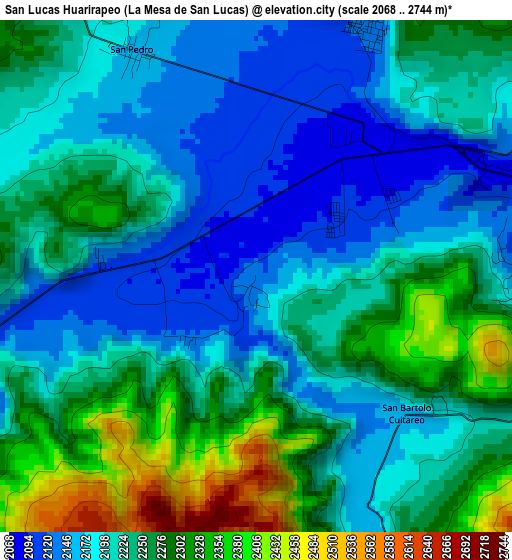
Below is the Elevation map of San Lucas Huarirapeo (La Mesa de San Lucas), which displays elevation range with different colors. Scale of the first map is from 2068 to 2744 m (6785 to 9003 ft) with average elevation of 2229 meters (=7313 ft) [note 1]
These maps also provides idea of topography and contour of this city, they are displayed at different zoom levels. More info about maps, scale and edge coordinates you can find below images.
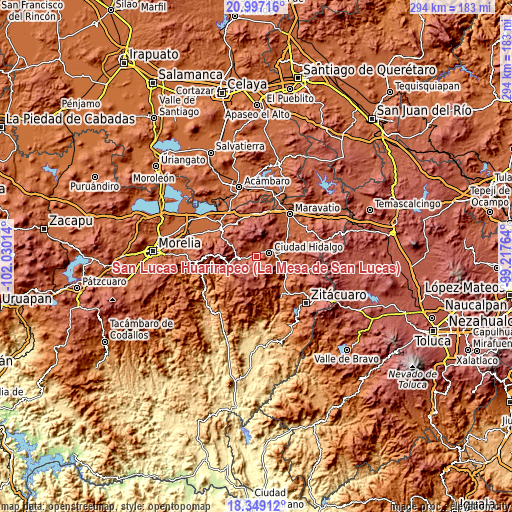
| \ | Map #1 | Topo.Map |
| Scale [m] | 2068..2744 m | × |
| Scale [ft] | 6785..9003 ft | × |
| Average | 2229 m = 7313 ft | × |
| Width | 9.2 km = 5.7 mi | 294.4 km = 182.9 mi |
| Height | 9.2 km = 5.7 mi | 294.5 km = 183 mi |
| ↑Max Latitude | 19.719983° | 20.99716° |
| Latitude at center | 19.67861° | 19.67861° |
| ↓Min Latitude | 19.637226° | 18.34912° |
| ← Min Longitude | -100.667835° | -102.03014° |
| Longitude center | -100.62389° | -100.62389° |
| →Max Longitude | -100.579945° | -99.21764° |
Nearby cities:
Cities around San Lucas Huarirapeo (La Mesa de San Lucas) sort by population:
• Ciudad Hidalgo elevation 2062 m
7.4 km,  77°
77°
• San Bartolo Cuitareo 2158 m
3.9 km,  141°
141°
• Huajúmbaro 2297 m
12.2 km,  271°
271°
• San Pedro Jácuaro 2168 m
4.6 km,  331°
331°
• Colonia Antorcha Campesina (Santa Rosa) 2060 m
10.2 km,  89°
89°
• San Isidro Alta Huerta 2190 m
5.4 km,  342°
342°
• Rincón de Cedeños (Rincón de Dolores) 2116 m
5 km, 90°
• Colonia Ecológica Asociación de Lucha Social (Lucha Social) 2103 m
1.9 km,  54°
54°
• Colonia Aquiles Córdoba Morán 2137 m
9.8 km,  71°
71°
• Aquiles Córdova Morán 2130 m
9.7 km, 71°
• Tierras Coloradas (San Pedro) 2186 m
5.1 km, 332°
• Colonia el Mirador (Llano del Ejido) 2067 m
7.4 km, 92°
Multilingual:
 En español:
San Lucas Huarirapeo (La Mesa de San Lucas) elevación 2138 m.
 En France:
San Lucas Huarirapeo (La Mesa de San Lucas) élévation 2138 m.
 Auf Deutsch:
San Lucas Huarirapeo (La Mesa de San Lucas) höhe über dem Meeresspiegel ist 2138 m.
 На русском:
San Lucas Huarirapeo (La Mesa de San Lucas) высота над уровнем моря 2138 м
Sources and notes:
- [note 1] Map square and city borders are not equal. Map elevation data is calculated only from area inside that square.
- [src 1] Elevation data from geonames database provided with same terms of usage.
- [src 2] The elevation map of San Lucas Huarirapeo (La Mesa de San Lucas) is generated using elevation data from NASA's 3 arcsec (90m) resolution SRTM data.
- [src 3] Base (background) map © OpenStreetMap contributors tiles are generated by Geofabrik and OpenTopoMap.
Copyright & License:
This San Lucas Huarirapeo (La Mesa de San Lucas) Elevation Map is licensed under CC BY-SA. You may reuse any part from this page, if you give a proper credit by linking to this URL:
 More info on terms of use page.