Angahuán elevation
Angahuán (Michoacán, Uruapan), Mexico elevation is 2396 meters and Angahuán elevation in feet is 7861 ft above sea level [src 1]. Angahuán is a populated place (feature code) with elevation that is 1082 meters (3550 ft) bigger than average city elevation in Mexico.
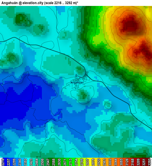
Below is the Elevation map of Angahuán, which displays elevation range with different colors. Scale of the first map is from 2216 to 3292 m (7270 to 10801 ft) with average elevation of 2484.4 meters (=8151 ft) [note 1]
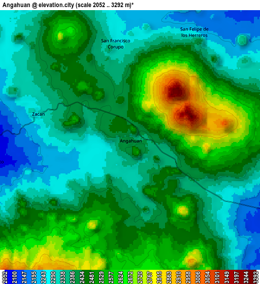
These maps also provides idea of topography and contour of this city, they are displayed at different zoom levels. More info about maps, scale and edge coordinates you can find below images.
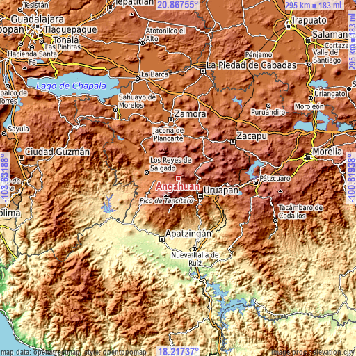
| \ | Map #1 | Map #2 | Topo.Map |
| Scale [m] | 2216..3292 m | 2052..3292 m | × |
| Scale [ft] | 7270..10801 ft | 6732..10801 ft | × |
| Average | 2484.4 m = 8151 ft | 2438.9 m = 8002 ft | × |
| Width | 9.21 km = 5.7 mi | 18.42 km = 11.4 mi | 294.7 km = 183.1 mi |
| Height | 9.21 km = 5.7 mi | 18.42 km = 11.4 mi | 294.7 km = 183.1 mi |
| ↑Max Latitude | 19.589307° | 19.630704° | 20.86755° |
| Latitude at center | 19.5479° | 19.5479° | 19.5479° |
| ↓Min Latitude | 19.506482° | 19.465054° | 18.21737° |
| ← Min Longitude | -102.269575° | -102.313521° | -103.63188° |
| Longitude center | -102.22563° | -102.22563° | -102.22563° |
| →Max Longitude | -102.181685° | -102.137739° | -100.81938° |
Nearby cities:
Cities around Angahuán sort by population:
• Nuevo San Juan Parangaricutiro elevation 1878 m
17.5 km,  145°
145°
• San Lorenzo 2109 m
12.4 km,  100°
100°
• Charapán 2368 m
11.8 km,  346°
346°
• Nurío 2182 m
15.7 km,  39°
39°
• Cocucho 2426 m
16.8 km,  13°
13°
• Nuevo Zirosto 1914 m
12.8 km,  270°
270°
• San Francisco Peribán 1629 m
18.1 km, 272°
• Corupo 2291 m
6.9 km, 351°
• San Felipe de los Herreros 2246 m
9 km,  31°
31°
• Zicuicho 2294 m
17.1 km,  318°
318°
• Santa Ana Zirosto 2034 m
10.4 km,  262°
262°
• Pomacuarán 2241 m
15.3 km,  57°
57°
Multilingual:
 En español:
Angahuán elevación 2396 m.
 En France:
Angahuán élévation 2396 m.
 Auf Deutsch:
Angahuán höhe über dem Meeresspiegel ist 2396 m.

Sources and notes:
- [note 1] Map square and city borders are not equal. Map elevation data is calculated only from area inside that square.
- [src 1] Elevation data from geonames database provided with same terms of usage.
- [src 2] The elevation map of Angahuán is generated using elevation data from NASA's 3 arcsec (90m) resolution SRTM data.
- [src 3] Base (background) map © OpenStreetMap contributors tiles are generated by Geofabrik and OpenTopoMap.
Copyright & License:
This Angahuán Elevation Map is licensed under CC BY-SA. You may reuse any part from this page, if you give a proper credit by linking to this URL:
 More info on terms of use page.