San Lorenzo elevation
San Lorenzo (Michoacán, Uruapan), Mexico elevation is 2109 meters and San Lorenzo elevation in feet is 6919 ft above sea level [src 1]. San Lorenzo is a populated place (feature code) with elevation that is 795 meters (2608 ft) bigger than average city elevation in Mexico.
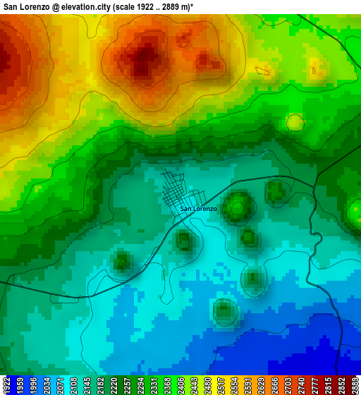
Below is the Elevation map of San Lorenzo, which displays elevation range with different colors. Scale of the first map is from 1922 to 2889 m (6306 to 9478 ft) with average elevation of 2277.3 meters (=7471 ft) [note 1]
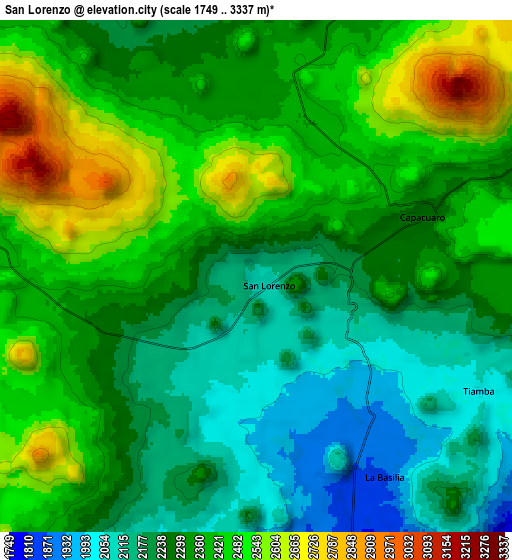
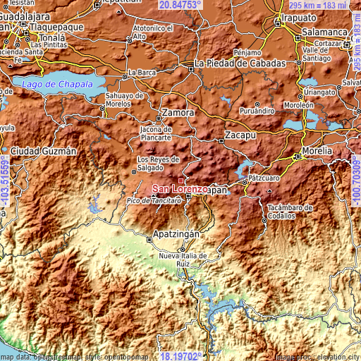
These maps also provides idea of topography and contour of this city, they are displayed at different zoom levels. More info about maps, scale and edge coordinates you can find below images.
| \ | Map #1 | Map #2 | Topo.Map |
| Scale [m] | 1922..2889 m | 1749..3337 m | × |
| Scale [ft] | 6306..9478 ft | 5738..10948 ft | × |
| Average | 2277.3 m = 7471 ft | 2336.8 m = 7667 ft | × |
| Width | 9.21 km = 5.7 mi | 18.42 km = 11.4 mi | 294.7 km = 183.1 mi |
| Height | 9.21 km = 5.7 mi | 18.42 km = 11.4 mi | 294.7 km = 183.1 mi |
| ↑Max Latitude | 19.569122° | 19.610524° | 20.84753° |
| Latitude at center | 19.52771° | 19.52771° | 19.52771° |
| ↓Min Latitude | 19.486287° | 19.444854° | 18.19702° |
| ← Min Longitude | -102.153285° | -102.197231° | -103.51559° |
| Longitude center | -102.10934° | -102.10934° | -102.10934° |
| →Max Longitude | -102.065395° | -102.021449° | -100.70309° |
Nearby cities:
Cities around San Lorenzo sort by population:
• Uruapan elevation 1620 m
14.1 km,  156°
156°
• Paracho de Verduzco 2226 m
14.7 km,  25°
25°
• Nuevo San Juan Parangaricutiro 1878 m
12.3 km,  190°
190°
• Capácuaro 2262 m
6.4 km,  70°
70°
• Angahuán 2396 m
12.4 km,  280°
280°
• Caltzontzín 1629 m
15.8 km,  137°
137°
• Nurío 2182 m
14.5 km,  351°
351°
• Toreo Bajo (El Toreo Bajo) 1685 m
14.4 km,  130°
130°
• Quinceo 2509 m
13.7 km,  57°
57°
• Ahuirán 2263 m
15.8 km,  13°
13°
• San Felipe de los Herreros 2246 m
12.5 km,  322°
322°
• Pomacuarán 2241 m
10.5 km,  3°
3°
Multilingual:
 En español:
San Lorenzo elevación 2109 m.
 En France:
San Lorenzo élévation 2109 m.
 Auf Deutsch:
San Lorenzo höhe über dem Meeresspiegel ist 2109 m.

Sources and notes:
- [note 1] Map square and city borders are not equal. Map elevation data is calculated only from area inside that square.
- [src 1] Elevation data from geonames database provided with same terms of usage.
- [src 2] The elevation map of San Lorenzo is generated using elevation data from NASA's 3 arcsec (90m) resolution SRTM data.
- [src 3] Base (background) map © OpenStreetMap contributors tiles are generated by Geofabrik and OpenTopoMap.
Copyright & License:
This San Lorenzo Elevation Map is licensed under CC BY-SA. You may reuse any part from this page, if you give a proper credit by linking to this URL:
 More info on terms of use page.