Nuevo San Juan Parangaricutiro elevation
Nuevo San Juan Parangaricutiro (Michoacán, Nuevo Parangaricutiro), Mexico elevation is 1878 meters and Nuevo San Juan Parangaricutiro elevation in feet is 6161 ft above sea level [src 1]. Nuevo San Juan Parangaricutiro is a seat of a second-order administrative division (feature code) with elevation that is 564 meters (1850 ft) bigger than average city elevation in Mexico.
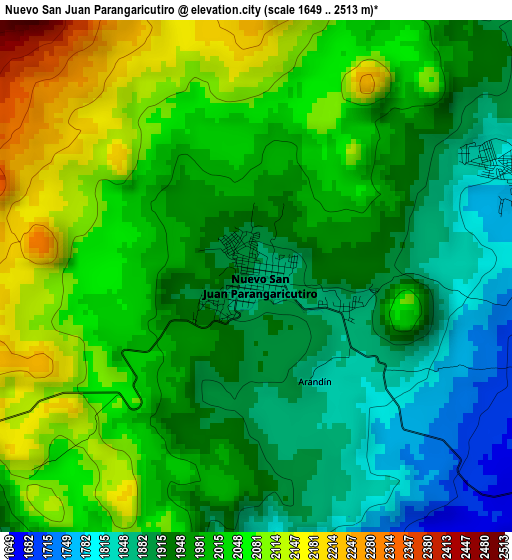
Below is the Elevation map of Nuevo San Juan Parangaricutiro, which displays elevation range with different colors. Scale of the first map is from 1649 to 2513 m (5410 to 8245 ft) with average elevation of 1986.1 meters (=6516 ft) [note 1]
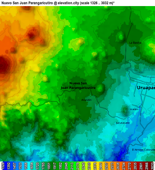
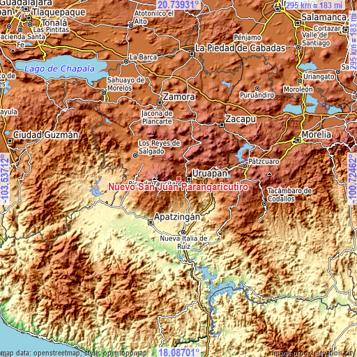
These maps also provides idea of topography and contour of this city, they are displayed at different zoom levels. More info about maps, scale and edge coordinates you can find below images.
| \ | Map #1 | Map #2 | Topo.Map |
| Scale [m] | 1649..2513 m | 1326..3032 m | × |
| Scale [ft] | 5410..8245 ft | 4350..9948 ft | × |
| Average | 1986.1 m = 6516 ft | 1984.5 m = 6511 ft | × |
| Width | 9.22 km = 5.7 mi | 18.43 km = 11.5 mi | 294.9 km = 183.2 mi |
| Height | 9.22 km = 5.7 mi | 18.43 km = 11.5 mi | 294.9 km = 183.2 mi |
| ↑Max Latitude | 19.46001° | 19.50144° | 20.73931° |
| Latitude at center | 19.41857° | 19.41857° | 19.41857° |
| ↓Min Latitude | 19.377119° | 19.335658° | 18.08701° |
| ← Min Longitude | -102.174815° | -102.218761° | -103.53712° |
| Longitude center | -102.13087° | -102.13087° | -102.13087° |
| →Max Longitude | -102.086925° | -102.042979° | -100.72462° |
Nearby cities:
Cities around Nuevo San Juan Parangaricutiro sort by population:
• Uruapan elevation 1620 m
7.8 km,  96°
96°
• Capácuaro 2262 m
16.5 km,  30°
30°
• Angahuán 2396 m
17.5 km,  325°
325°
• Caltzontzín 1629 m
13 km,  87°
87°
• San Lorenzo 2109 m
12.3 km,  10°
10°
• Toreo Bajo (El Toreo Bajo) 1685 m
13.6 km,  77°
77°
• Santa Rosa (Santa Bárbara) 1596 m
10.7 km,  111°
111°
• San Andrés Coru 1681 m
20.2 km,  74°
74°
• Jucutacato 1603 m
7.1 km,  129°
129°
• Emiliano Zapata 1136 m
22.4 km, 113°
• Zirimícuaro 1360 m
18.1 km, 93°
• Charapendo 1011 m
18.5 km,  158°
158°
Multilingual:
 En español:
Nuevo San Juan Parangaricutiro elevación 1878 m.
 En France:
Nuevo San Juan Parangaricutiro élévation 1878 m.
 Auf Deutsch:
Nuevo San Juan Parangaricutiro höhe über dem Meeresspiegel ist 1878 m.
 На русском:
Nuevo San Juan Parangaricutiro высота над уровнем моря 1878 м
Sources and notes:
- [note 1] Map square and city borders are not equal. Map elevation data is calculated only from area inside that square.
- [src 1] Elevation data from geonames database provided with same terms of usage.
- [src 2] The elevation map of Nuevo San Juan Parangaricutiro is generated using elevation data from NASA's 3 arcsec (90m) resolution SRTM data.
- [src 3] Base (background) map © OpenStreetMap contributors tiles are generated by Geofabrik and OpenTopoMap.
Copyright & License:
This Nuevo San Juan Parangaricutiro Elevation Map is licensed under CC BY-SA. You may reuse any part from this page, if you give a proper credit by linking to this URL:
 More info on terms of use page.