Charapán elevation
Charapán (Michoacán, Charapan), Mexico elevation is 2368 meters and Charapán elevation in feet is 7769 ft above sea level [src 1]. Charapán is a populated place (feature code) with elevation that is 1054 meters (3458 ft) bigger than average city elevation in Mexico.
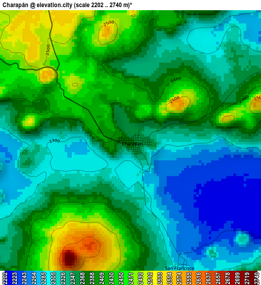
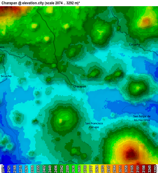
Below is the Elevation map of Charapán, which displays elevation range with different colors. Scale of the first map is from 2202 to 2740 m (7224 to 8990 ft) with average elevation of 2368.5 meters (=7771 ft) [note 1]
These maps also provides idea of topography and contour of this city, they are displayed at different zoom levels. More info about maps, scale and edge coordinates you can find below images.
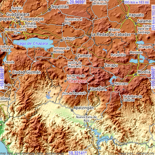
| \ | Map #1 | Map #2 | Topo.Map |
| Scale [m] | 2202..2740 m | 2074..3292 m | × |
| Scale [ft] | 7224..8990 ft | 6804..10801 ft | × |
| Average | 2368.5 m = 7771 ft | 2423.4 m = 7951 ft | × |
| Width | 9.2 km = 5.7 mi | 18.41 km = 11.4 mi | 294.5 km = 183 mi |
| Height | 9.2 km = 5.7 mi | 18.41 km = 11.4 mi | 294.5 km = 183 mi |
| ↑Max Latitude | 19.6925° | 19.73387° | 20.9699° |
| Latitude at center | 19.65112° | 19.65112° | 19.65112° |
| ↓Min Latitude | 19.609729° | 19.568327° | 18.32141° |
| ← Min Longitude | -102.295845° | -102.339791° | -103.65815° |
| Longitude center | -102.2519° | -102.2519° | -102.2519° |
| →Max Longitude | -102.207955° | -102.164009° | -100.84565° |
Nearby cities:
Cities around Charapán sort by population:
• Angahuán elevation 2396 m
11.8 km,  166°
166°
• Nurío 2182 m
12.8 km,  87°
87°
• Pamatácuaro 2419 m
10.8 km,  294°
294°
• Cocucho 2426 m
8.2 km,  53°
53°
• Nuevo Zirosto 1914 m
15.2 km,  221°
221°
• Corupo 2291 m
5 km,  159°
159°
• San Felipe de los Herreros 2246 m
8.3 km,  117°
117°
• Zicuicho 2294 m
8.6 km,  278°
278°
• Santa Ana Zirosto 2034 m
15 km,  210°
210°
• San Isidro 2589 m
10.9 km,  334°
334°
• Santa María Urapicho 2314 m
15 km,  77°
77°
• San Benito 2594 m
9.6 km,  310°
310°
Multilingual:
 En español:
Charapán elevación 2368 m.
 En France:
Charapán élévation 2368 m.
 Auf Deutsch:
Charapán höhe über dem Meeresspiegel ist 2368 m.

Sources and notes:
- [note 1] Map square and city borders are not equal. Map elevation data is calculated only from area inside that square.
- [src 1] Elevation data from geonames database provided with same terms of usage.
- [src 2] The elevation map of Charapán is generated using elevation data from NASA's 3 arcsec (90m) resolution SRTM data.
- [src 3] Base (background) map © OpenStreetMap contributors tiles are generated by Geofabrik and OpenTopoMap.
Copyright & License:
This Charapán Elevation Map is licensed under CC BY-SA. You may reuse any part from this page, if you give a proper credit by linking to this URL:
 More info on terms of use page.